Donchery
show This article may be expanded with text translated from the corresponding article in French. (December 2008) Click [show] for important translation instructions. |
Donchery | |
|---|---|
Commune | |
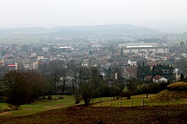 A general view of Donchery | |
 Coat of arms | |
show Location of Donchery | |
 Donchery | |
| Coordinates: 49°41′50″N 4°52′31″E / 49.6972°N 4.8753°ECoordinates: 49°41′50″N 4°52′31″E / 49.6972°N 4.8753°E | |
| Country | France |
| Region | Grand Est |
| Department | Ardennes |
| Arrondissement | Sedan |
| Canton | Sedan-1 |
| Intercommunality | CA Ardenne Métropole |
| Government | |
| • Mayor (2020–2026) | Christian Welter[1] |
| Area 1 | 27.36 km2 (10.56 sq mi) |
| Population (Jan. 2018)[2] | 2,029 |
| • Density | 74/km2 (190/sq mi) |
| Time zone | UTC+01:00 (CET) |
| • Summer (DST) | UTC+02:00 (CEST) |
| INSEE/Postal code | 08142 /08350 |
| Elevation | 147–408 m (482–1,339 ft) (avg. 151 m or 495 ft) |
| 1 French Land Register data, which excludes lakes, ponds, glaciers > 1 km2 (0.386 sq mi or 247 acres) and river estuaries. | |


Donchery (French pronunciation: [dɔ̃ʃʁi]) is a commune in the Ardennes department in northern France.
Population[]
| Year | Pop. | ±% |
|---|---|---|
| 1962 | 1,598 | — |
| 1968 | 1,963 | +22.8% |
| 1975 | 2,346 | +19.5% |
| 1982 | 2,293 | −2.3% |
| 1990 | 2,362 | +3.0% |
| 1999 | 2,393 | +1.3% |
| 2008 | 2,409 | +0.7% |
See also[]
References[]
- ^ "Répertoire national des élus: les maires". data.gouv.fr, Plateforme ouverte des données publiques françaises (in French). 2 December 2020.
- ^ "Populations légales 2018". INSEE. 28 December 2020.
| Wikimedia Commons has media related to Donchery. |
| Authority control |
|
|---|
This Ardennes geographical article is a stub. You can help Wikipedia by . |
Categories:
- Communes of Ardennes (department)
- Ardennes (department) geography stubs