Drslavice (Uherské Hradiště District)
Drslavice | |
|---|---|
Municipality | |
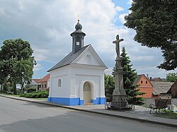 Chapel of Our Lady of Hostýn | |
 Flag  Coat of arms | |
 Drslavice | |
| Coordinates: 49°2′51″N 17°36′4″E / 49.04750°N 17.60111°ECoordinates: 49°2′51″N 17°36′4″E / 49.04750°N 17.60111°E | |
| Country | |
| Region | Zlín |
| District | Uherské Hradiště |
| Area | |
| • Total | 7.9 km2 (3.1 sq mi) |
| Elevation | 204 m (669 ft) |
| Population (2006) | |
| • Total | 514 |
| • Density | 65/km2 (170/sq mi) |
| Postal code | 687 33 |
| Website | http://www.drslavice.cz |

Drslavice (German: Derslawitz) is a village and municipality (obec) in Uherské Hradiště District in the Zlín Region of the Czech Republic.
The municipality covers an area of 7.9 square kilometres (3.1 sq mi), and has a population of 514 (as at 28 August 2006).
Drslavice lies approximately 11 kilometres (7 mi) east of Uherské Hradiště, 22 km (14 mi) south of Zlín, and 257 km (160 mi) south-east of Prague.
People[]
- Adolf Jellinek, rabbi
References[]
| Wikimedia Commons has media related to Drslavice (Uherské Hradiště District). |
| Authority control: National libraries |
|---|
This Zlín Region location article is a stub. You can help Wikipedia by . |
This article related to Jewish history is a stub. You can help Wikipedia by . |
Categories:
- Villages in Uherské Hradiště District
- Shtetls
- Zlín Region geography stubs
- Jewish history stubs