Horní Němčí
Horní Němčí | |
|---|---|
Municipality | |
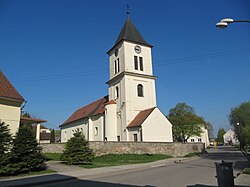 Church of Saints Peter and Paul | |
 Flag  Coat of arms | |
 Horní Němčí | |
| Coordinates: 48°55′39″N 17°37′57″E / 48.92750°N 17.63250°ECoordinates: 48°55′39″N 17°37′57″E / 48.92750°N 17.63250°E | |
| Country | |
| Region | Zlín |
| District | Uherské Hradiště |
| Area | |
| • Total | 18.05 km2 (6.97 sq mi) |
| Elevation | 334 m (1,096 ft) |
| Population (2006) | |
| • Total | 850 |
| • Density | 47/km2 (120/sq mi) |
| Postal code | 687 64 |
| Website | http://www.horninemci.cz |

Horní Němčí is a village and municipality (obec) in Uherské Hradiště District in the Zlín Region of the Czech Republic.
The municipality covers an area of 18.05 square kilometres (6.97 sq mi), and has a population of 850 (as at 3 July 2006).
Horní Němčí lies approximately 20 kilometres (12 mi) south-east of Uherské Hradiště, 41 km (25 mi) south of Zlín, and 297 km (185 mi) south-east of Prague.
References[]
| Wikimedia Commons has media related to Horní Němčí. |
| Authority control: National libraries |
|---|
This Zlín Region location article is a stub. You can help Wikipedia by . |
Categories:
- Villages in Uherské Hradiště District
- Zlín Region geography stubs