East Tennessee


East Tennessee is one of the three Grand Divisions of Tennessee defined in state law. Geographically and socioculturally distinct, it comprises approximately the eastern third of the U.S. state of Tennessee. East Tennessee consists of 33 counties, 30 located within the Eastern Time Zone and three counties in the Central Time Zone, namely Bledsoe, Cumberland, and Marion.[1] East Tennessee is entirely located within the Appalachian Mountains, although the landforms range from densely forested 6,000-foot (1,800 m) mountains to broad river valleys. The region contains the major cities of Knoxville and Chattanooga, Tennessee's third and fourth largest cities, respectively, and the Tri-Cities, the state's sixth largest population center.
During the American Civil War, most East Tennesseans remained loyal to the Union even as the state seceded and joined the Confederacy. Early in the war Unionist delegates unsuccessfully attempted to split East Tennessee into a separate state that would remain a part of the Union. After the war, a number of industrial operations were established in cities in the region. The Tennessee Valley Authority (TVA) was created by Congress during the Great Depression, and spurred economic development and helped to modernize the region's economy and society, and today has its administrative operations headquartered in Knoxville and its power operations headquartered in Chattanooga. Oak Ridge was the site of the world's first successful uranium enrichment operations which paved the way for the atomic age.[2] The Appalachian Regional Commission further transformed the region in the latter 20th century.
East Tennessee is both geographically and culturally part of Appalachia, and has been included— along with Western North Carolina, North Georgia, Eastern Kentucky, Southwest Virginia, the state of West Virginia, western Maryland, and southwestern Pennsylvania — in every major definition of the Appalachian region since the early 20th century.[3] East Tennessee is home to the nation's most visited national park— the Great Smoky Mountains National Park— and hundreds of smaller recreational areas. East Tennessee is often called the birthplace of country music, due largely to the 1927 Victor recording sessions in Bristol, and throughout the 20th and 21st centuries has produced a steady stream of musicians of national and international fame.[4]
Geography[]

Unlike the geographic designations of regions of most U.S. states, the term East Tennessee has legal as well as socioeconomic and cultural meaning. East Tennessee, along with Middle Tennessee and West Tennessee, comprises one of the state's three Grand Divisions. According to the Tennessee State Constitution, no more than two of the Tennessee Supreme Court's five justices can come from any one Grand Division.[5] The Supreme Court rotates meeting in courthouses in each of the three divisions. The Supreme Court building for East Tennessee is in Knoxville. A similar rule applies to certain other commissions and boards as well, to prevent them from showing a geographic bias.
East Tennessee has a total land area of 13,558.27 square miles (35,115.8 km2), making it second to Middle Tennessee among the state's Grand Divisions. East Tennessee's land area is approximately 32.90% of the state's total land area.
Topography[]
East Tennessee is located within three major geological divisions of the Appalachian Mountains; the Blue Ridge Mountains on the border with North Carolina in the east, the Ridge-and-Valley Appalachians (usually called the "Great Appalachian Valley" or "Tennessee Valley"[a]) in the center, and the Cumberland Plateau in the west, part of which is in Middle Tennessee. The southern tip of the Cumberland Mountains also extend into the region between the Cumberland Plateau and Ridge-and-Valley regions. Both the Cumberland Plateau and Cumberland Mountains are part of the larger Appalachian Plateau.[6]

The Blue Ridge section comprises the western (or "Unaka") section of the Blue Ridge Province, the crests of which forms most of the Tennessee-North Carolina border. At an average elevation of 5,000 feet (1,500 m) above sea level, this physiographic province contains the highest elevations in the state.[7] The Blue Ridge region is subdivided into several subranges— the Iron Mountains, Roan Highlands, and Bald Mountains in the north, the Great Smoky Mountains in the center, and the Unicoi Mountains and the Little Frog and Big Frog Mountain areas in the south.[8] Clingmans Dome, at 6,643 feet (2,025 m), is the state's highest point, and is located in the Great Smoky Mountains along the Tennessee-North Carolina border.[7] Most of the Blue Ridge section is heavily forested and protected by various state and federal entities, the largest of which include the Great Smoky Mountains National Park and the Cherokee National Forest.[9] The Appalachian Trail enters Tennessee in the Great Smoky Mountains, and roughly follows the border with North Carolina most of the distance to near the Roan Mountain, where it shifts entirely into Tennessee.[10]
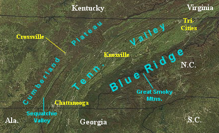
The Ridge-and-Valley division is East Tennessee's largest and most populous section. It consists of a series of alternating and paralleling elongate ridges with broad river valleys in between, roughly oriented northeast-to-southwest. This section's most notable feature, the Tennessee River, forms at the confluence of the Holston and French Broad rivers in Knoxville, and flows southwestward to Chattanooga. Other notable rivers in the upper Tennessee watershed include the Clinch, Nolichucky, Watauga, Emory, Little Tennessee, Hiwassee, Sequatchie, and Ocoee rivers. Notable "ridges" in the Ridge-and-Valley range, which exceed elevations much greater than most surrounding ridges, include Clinch Mountain, Bays Mountain, and Powell Mountain.[7]
The Cumberland Plateau rises nearly 1,000 feet (300 m) above the Appalachian Valley, stretching from the Kentucky border in the north to the Georgia and Alabama borders in the south.[7] It has an average elevation of 2,000 feet (610 m), and consists mostly of flat-topped tablelands, although the northern section is slightly more rugged.[6][11] The plateau also has many waterfalls and stream valleys separated by steep gorges.[12] The "Tennessee Divide" runs along the western part of the plateau, and separates the watersheds of the Tennessee and Cumberland rivers. Plateau counties mostly east of this divide— i.e. Cumberland, Morgan, and Scott— are grouped with East Tennessee, whereas plateau counties west of this divide, such as Fentress, Van Buren, and Grundy, are considered part of Middle Tennessee. Most of the Sequatchie Valley, a long narrow valley in the southeastern part of the Cumberland Plateau, is in East Tennessee.[b] The part of the Plateau east of the Sequatchie Valley is called Walden Ridge. One notable detached section of the Plateau is Lookout Mountain, which overlooks Chattanooga.[14] West of Chattanooga, the Tennessee River flows through the plateau in the Tennessee River Gorge.
The Cumberland Mountains begin directly north of the Sequatchie Valley, and extend northward to the Cumberland Gap at the Tennessee-Kentucky-Virginia tripoint. While technically a separate physiographic region, the Cumberland Mountains are usually considered part of the Cumberland Plateau in Tennessee. The Cumberland Mountains reach elevations above 3,500 feet (1,100 m) in Tennessee, and their largest subrage is the Crab Orchard Mountains. The Cumberland Trail traverses the eastern escarpment of the Cumberland Plateau and Cumberland Mountains.[15]
Counties[]
- Anderson
- Bledsoe
- Blount
- Bradley
- Campbell
- Carter
- Claiborne
- Cocke
- Cumberland
- Grainger
- Greene
- Hamblen
- Hamilton
- Hancock
- Hawkins
- Jefferson
- Johnson
- Knox
- Loudon
- Marion
- McMinn
- Meigs
- Monroe
- Morgan
- Polk
- Rhea
- Roane
- Scott
- Sevier
- Sullivan
- Unicoi
- Union
- Washington
The Official Tourism Website of Tennessee has a definition of East Tennessee slightly different from the legal definition; the website excludes Cumberland County while including Grundy and Sequatchie Counties.[16]
Cities[]
The major cities of East Tennessee are Knoxville (near the center of East Tennessee), Chattanooga (in southeastern Tennessee at the Georgia border), and the "Tri-Cities" of Bristol, Johnson City, and Kingsport located in the extreme northeasternmost part of the state. The Blue Ridge section of the state is much more sparsely populated, its main cities being Elizabethton, Gatlinburg, and Tellico Plains. Crossville and Jasper are prominent cities in the Plateau region.
- Cities and towns with 10,000+ population (2016 estimates)
- Knoxville (pop. 183,927)
- Chattanooga (pop. 175,462)
- Johnson City (pop. 66,677)
- Kingsport (pop. 52,871)
- Cleveland (pop. 44,271)
- Morristown (pop. 29,663)
- Oak Ridge (pop. 29,330)
- Maryville (pop. 28,703)
- Bristol (pop. 27,109)
- Farragut (pop. 22,282)
- East Ridge (pop. 21,311)
- Sevierville (pop. 16,665)
- Greeneville (pop. 15,062)
- Elizabethton (pop. 13,854)
- Athens (pop. 13,748)
- Soddy-Daisy (pop. 13,217)
- Middle Valley (pop. 12,699)
- Red Bank (pop. 11,813)
- Crossville (pop. 11,455)
- Clinton (pop. 10,106)
Climate[]
| hideClimate data for Chattanooga Metropolitan Airport, Tennessee (1991–2020 normals,[c] extremes 1879–present[d]) | |||||||||||||
|---|---|---|---|---|---|---|---|---|---|---|---|---|---|
| Month | Jan | Feb | Mar | Apr | May | Jun | Jul | Aug | Sep | Oct | Nov | Dec | Year |
| Record high °F (°C) | 78 (26) |
81 (27) |
89 (32) |
93 (34) |
99 (37) |
107 (42) |
107 (42) |
105 (41) |
104 (40) |
100 (38) |
86 (30) |
78 (26) |
107 (42) |
| Mean maximum °F (°C) | 69 (21) |
73 (23) |
81 (27) |
86 (30) |
90 (32) |
95 (35) |
97 (36) |
96 (36) |
93 (34) |
86 (30) |
77 (25) |
69 (21) |
98 (37) |
| Average high °F (°C) | 51.0 (10.6) |
55.6 (13.1) |
64.1 (17.8) |
73.6 (23.1) |
81.0 (27.2) |
87.6 (30.9) |
90.5 (32.5) |
89.8 (32.1) |
84.3 (29.1) |
74.1 (23.4) |
62.0 (16.7) |
53.2 (11.8) |
72.2 (22.3) |
| Daily mean °F (°C) | 41.7 (5.4) |
45.6 (7.6) |
53.2 (11.8) |
61.7 (16.5) |
70.0 (21.1) |
77.4 (25.2) |
80.7 (27.1) |
80.0 (26.7) |
73.9 (23.3) |
62.7 (17.1) |
51.2 (10.7) |
44.3 (6.8) |
61.9 (16.6) |
| Average low °F (°C) | 32.4 (0.2) |
35.6 (2.0) |
42.2 (5.7) |
49.9 (9.9) |
59.0 (15.0) |
67.3 (19.6) |
71.0 (21.7) |
70.2 (21.2) |
63.6 (17.6) |
51.4 (10.8) |
40.3 (4.6) |
35.3 (1.8) |
51.5 (10.8) |
| Mean minimum °F (°C) | 15 (−9) |
20 (−7) |
26 (−3) |
34 (1) |
44 (7) |
57 (14) |
63 (17) |
62 (17) |
50 (10) |
35 (2) |
26 (−3) |
21 (−6) |
13 (−11) |
| Record low °F (°C) | −10 (−23) |
−10 (−23) |
2 (−17) |
25 (−4) |
34 (1) |
39 (4) |
51 (11) |
50 (10) |
36 (2) |
22 (−6) |
4 (−16) |
−2 (−19) |
−10 (−23) |
| Average precipitation inches (mm) | 5.02 (128) |
5.03 (128) |
5.34 (136) |
4.87 (124) |
3.94 (100) |
4.18 (106) |
5.08 (129) |
3.67 (93) |
4.23 (107) |
3.59 (91) |
4.80 (122) |
5.25 (133) |
55.00 (1,397) |
| Average snowfall inches (cm) | 1.0 (2.5) |
1.2 (3.0) |
1.1 (2.8) |
0.0 (0.0) |
0.0 (0.0) |
0.0 (0.0) |
0.0 (0.0) |
0.0 (0.0) |
0.0 (0.0) |
0.0 (0.0) |
0.0 (0.0) |
0.3 (0.76) |
3.6 (9.1) |
| Average precipitation days (≥ 0.01 in) | 10.6 | 11.1 | 11.4 | 10.1 | 10.6 | 11.4 | 11.9 | 9.4 | 7.9 | 7.9 | 9.1 | 11.3 | 122.7 |
| Average snowy days (≥ 0.1 in) | 0.7 | 1.1 | 0.3 | 0.0 | 0.0 | 0.0 | 0.0 | 0.0 | 0.0 | 0.0 | 0.0 | 0.3 | 2.4 |
| Average relative humidity (%) | 71.2 | 68.2 | 65.9 | 63.8 | 71.5 | 73.1 | 74.9 | 76.0 | 77.0 | 74.6 | 73.5 | 72.9 | 71.9 |
| Mean monthly sunshine hours | 147.0 | 155.6 | 200.5 | 240.2 | 275.6 | 275.5 | 265.2 | 256.8 | 227.9 | 218.8 | 158.7 | 140.4 | 2,562.2 |
| Percent possible sunshine | 47 | 51 | 54 | 61 | 64 | 63 | 60 | 62 | 61 | 63 | 51 | 46 | 58 |
| Source: NOAA (relative humidity and sun 1961–1990)[18][19][20] | |||||||||||||
| hideClimate data for Knoxville (McGhee Tyson Airport), 1991−2020 normals,[e] extremes 1871–present[f] | |||||||||||||
|---|---|---|---|---|---|---|---|---|---|---|---|---|---|
| Month | Jan | Feb | Mar | Apr | May | Jun | Jul | Aug | Sep | Oct | Nov | Dec | Year |
| Record high °F (°C) | 77 (25) |
83 (28) |
88 (31) |
93 (34) |
96 (36) |
105 (41) |
105 (41) |
102 (39) |
103 (39) |
96 (36) |
85 (29) |
80 (27) |
105 (41) |
| Mean maximum °F (°C) | 68 (20) |
72 (22) |
78 (26) |
85 (29) |
89 (32) |
93 (34) |
95 (35) |
94 (34) |
92 (33) |
84 (29) |
76 (24) |
69 (21) |
96 (36) |
| Average high °F (°C) | 48.2 (9.0) |
52.8 (11.6) |
61.4 (16.3) |
71.2 (21.8) |
78.9 (26.1) |
85.7 (29.8) |
88.4 (31.3) |
87.8 (31.0) |
82.5 (28.1) |
71.7 (22.1) |
60.0 (15.6) |
51.0 (10.6) |
70.0 (21.1) |
| Daily mean °F (°C) | 39.1 (3.9) |
42.9 (6.1) |
50.6 (10.3) |
59.6 (15.3) |
67.9 (19.9) |
75.3 (24.1) |
78.5 (25.8) |
77.6 (25.3) |
71.8 (22.1) |
60.3 (15.7) |
49.0 (9.4) |
41.9 (5.5) |
59.5 (15.3) |
| Average low °F (°C) | 30.0 (−1.1) |
33.1 (0.6) |
39.8 (4.3) |
48.0 (8.9) |
56.9 (13.8) |
64.9 (18.3) |
68.7 (20.4) |
67.5 (19.7) |
61.1 (16.2) |
48.9 (9.4) |
38.1 (3.4) |
32.8 (0.4) |
49.2 (9.6) |
| Mean minimum °F (°C) | 12 (−11) |
17 (−8) |
23 (−5) |
33 (1) |
41 (5) |
55 (13) |
61 (16) |
60 (16) |
48 (9) |
33 (1) |
24 (−4) |
18 (−8) |
9 (−13) |
| Record low °F (°C) | −24 (−31) |
−10 (−23) |
1 (−17) |
22 (−6) |
32 (0) |
42 (6) |
49 (9) |
49 (9) |
35 (2) |
24 (−4) |
5 (−15) |
−6 (−21) |
−24 (−31) |
| Average precipitation inches (mm) | 4.76 (121) |
4.81 (122) |
4.89 (124) |
4.71 (120) |
4.13 (105) |
4.24 (108) |
5.25 (133) |
3.63 (92) |
3.49 (89) |
2.81 (71) |
4.21 (107) |
5.00 (127) |
51.93 (1,319) |
| Average snowfall inches (cm) | 1.7 (4.3) |
1.4 (3.6) |
0.9 (2.3) |
0.0 (0.0) |
0.0 (0.0) |
0.0 (0.0) |
0.0 (0.0) |
0.0 (0.0) |
0.0 (0.0) |
0.0 (0.0) |
0.1 (0.25) |
0.5 (1.3) |
4.6 (12) |
| Average precipitation days (≥ 0.01 in) | 11.5 | 11.7 | 12.7 | 11.1 | 11.1 | 12.0 | 11.6 | 9.8 | 7.8 | 8.0 | 9.4 | 12.0 | 128.7 |
| Average snowy days (≥ 0.1 in) | 1.2 | 1.3 | 0.7 | 0.0 | 0.0 | 0.0 | 0.0 | 0.0 | 0.0 | 0.0 | 0.2 | 0.6 | 4.0 |
| Average relative humidity (%) | 71.7 | 68.0 | 64.8 | 63.3 | 70.8 | 73.5 | 75.7 | 76.3 | 76.1 | 73.0 | 71.8 | 72.9 | 71.5 |
| Mean monthly sunshine hours | 135.8 | 145.3 | 208.9 | 256.6 | 287.2 | 291.1 | 287.3 | 278.0 | 232.3 | 217.2 | 151.7 | 122.5 | 2,613.9 |
| Percent possible sunshine | 44 | 48 | 56 | 65 | 66 | 67 | 65 | 67 | 62 | 62 | 49 | 40 | 59 |
| Source: NOAA (relative humidity and sun 1961–1990)[21][22][23] | |||||||||||||
Population and demographics[]
| Historical population | |||
|---|---|---|---|
| Census | Pop. | %± | |
| 1790 | 25,030 | — | |
| 1800 | 73,419 | 193.3% | |
| 1810 | 101,367 | 38.1% | |
| 1820 | 138,023 | 36.2% | |
| 1830 | 196,357 | 42.3% | |
| 1840 | 224,259 | 14.2% | |
| 1850 | 260,397 | 16.1% | |
| 1860 | 301,001 | 15.6% | |
| 1870 | 332,547 | 10.5% | |
| 1880 | 428,704 | 28.9% | |
| 1890 | 543,091 | 26.7% | |
| 1900 | 640,222 | 17.9% | |
| 1910 | 732,471 | 14.4% | |
| 1920 | 814,648 | 11.2% | |
| 1930 | 960,133 | 17.9% | |
| 1940 | 1,101,099 | 14.7% | |
| 1950 | 1,288,886 | 17.1% | |
| 1960 | 1,377,281 | 6.9% | |
| 1970 | 1,486,765 | 7.9% | |
| 1980 | 1,768,149 | 18.9% | |
| 1990 | 1,832,138 | 3.6% | |
| 2000 | 2,108,133 | 15.1% | |
| 2010 | 2,327,544 | 10.4% | |
| 2020 | 2,470,105 | 6.1% | |
| Source: 1910–2020[24] | |||
East Tennessee is the second most populous and most densely populated of the three Grand Divisions. At the 2020 census it had 2,470,105 inhabitants living in its 33 counties, and increase of 142,561, or 6.12%, over the 2010 figure of 2,327,544 residents. Its population was 35.74% of the state's total, and its population density was 182.18 square miles (471.8 km2) inhabitants per square mile.[25] Prior to the 2010 census, East Tennessee was the most populous of the state's Grand Divisions, but was surpassed by Middle Tennessee, which contains the rapidly-growing Nashville and Clarksville metropolitan areas.
Demographically, East Tennessee is one of the regions in the United States with one of the highest concentrations of people who identify as White or European American.[26] In the 2010 census, every county in East Tennessee except for Knox and Hamilton, the two most populous counties, had a population that was greater than 90% White.[27] In most counties in East Tennessee, persons of Hispanic or Latino origins outnumber African Americans, which is uncommon in the Southeastern United States.[27] Large African American populations are found in Chattanooga and Knoxville, as well as considerable populations in several smaller cities.[27]
Of the ten metropolitan statistical areas in Tennessee, six are located in East Tennessee. They are, in order of population, Knoxville, Chattanooga, Kingsport-Bristol, Johnson City, Cleveland, and Morristown. Also included in East Tennessee are the Knoxville-Sevierville-La Follette, Chattanooga-Cleveland-Athens and Tri-Cities combined statistical areas.[28]
Congressional districts[]
East Tennessee includes all of the state's 1st, 2nd, and 3rd congressional districts, and part of the 4th district. The First District is concentrated around the Tri-Cities region and Upper East Tennessee. The Second District includes Knoxville and the mountain counties to the south. The Third District includes the Chattanooga area and the counties north of Knoxville (the two areas are connected by a narrow corridor in eastern Roane County). The Fourth, which extends into an area southwest of Nashville, includes several of East Tennessee's Cumberland Plateau counties.
History[]
Native Americans[]
Much of what is known about East Tennessee's prehistoric Native Americans comes as a result of the Tennessee Valley Authority's reservoir construction, as federal law required archaeological investigations to be conducted in areas that were to be flooded. Excavations at the Icehouse Bottom site near Vonore revealed that Native Americans were living in East Tennessee on at least a semi-annual basis as early as 7,500 B.C.[29] The region's significant Woodland period (1000 B.C. – 1000 A.D.) sites include Rose Island (also near Vonore) and Moccasin Bend (near Chattanooga).[29][30] During what archaeologists call the Mississippian period (c. 1000–1600 A.D.), East Tennessee's Indigenous inhabitants were living in complex agrarian societies at places such as Toqua and Hiwassee Island, and had formed a minor chiefdom known as Chiaha in the French Broad Valley.[31] Spanish expeditions led by Hernando de Soto, Tristan de Luna, and Juan Pardo all visited East Tennessee's Mississippian-period inhabitants during the 16th century.[32] Some of the Native peoples who are known to have inhabited the region during this time include the Muscogee Creek, Yuchi, and Shawnee.[33][31]
By the early 18th century, most Natives in Tennessee had disappeared, very likely wiped out by diseases introduced by the Spaniards, leaving the region sparsely populated.[31] The Cherokee began migrating into what is now East Tennessee from what is now Virginia in the latter 17th century, possibly to escape expanding European settlement and diseases in the north.[34] The Cherokee established a series of towns concentrated in the Little Tennessee and Hiwassee valleys that became known as the "Overhill towns", as traders from North Carolina, South Carolina, and Virginia had to cross "over" the mountains to reach them. Early in the 18th century, the Cherokee forced the remaining members of other Native American groups out of the state.
Pioneer period[]

The first recorded Europeans to reach what is now East Tennessee were three expeditions led by Spanish explorers: Hernando de Soto in 1540–1541, Tristan de Luna in 1559, and Juan Pardo in 1566–1567.[35][36][37] Pardo recorded the name "Tanasqui" from a local Native American village, which evolved into the state's current name.[32] In 1673, Abraham Wood, a British fur trader, sent an expedition led by James Needham and Gabriel Arthur from Fort Henry in the Colony of Virginia into Overhill Cherokee territory in modern-day northeastern Tennessee.[38] Needham was killed during the expedition and Arthur was taken prisoner, and remained with the Cherokees for more than a year.[39] Longhunters from Virginia explored much of East Tennessee in the 1750s and 1760s in expeditions which lasted several months or even years.[40]
The Cherokee alliance with Britain during the French and Indian War led to the construction of Fort Loudoun in 1756 near present-day Vonore, which was the first British settlement in what is now Tennessee.[41] Fort Loudoun was the westernmost British outpost to that date, and was designed by John William Gerard de Brahm and constructed by forces under Captain Raymond Demeré.[42] Shortly after its completion, Demeré relinquished command of the fort to his brother, Captain Paul Demeré.[43] Hostilities erupted between the British and the Overhill Cherokees into an armed conflict, and a siege of the fort ended with its surrender in 1760.[44] The next morning, Paul Demeré and a number of his men were killed in an ambush nearby, and most of the rest of the garrison was taken prisoner.[45] A peace expedition led by Henry Timberlake in 1761 provided later travelers with invaluable knowledge regarding the location of the Overhill towns and the customs of the Overhill Cherokee.
The end of the French and Indian War in 1763 brought a stream of explorers and traders into the region, among them additional longhunters. In an effort to mitigate conflicts with the Natives, Britain issued the Royal Proclamation of 1763, which forbade settlements west of the Appalachian Mountains.[46] Despite this proclamation, migration across the mountains continued, and the first permanent European settlers began arriving in northeastern Tennessee in the late 1760s.[47][48] In 1769, William Bean— an associate of famed explorer Daniel Boone— built what is generally acknowledged as Tennessee's first permanent Euro-American residence in Tennessee along the Watauga River in present-day Johnson City.[49][50] Shortly thereafter, James Robertson and a group of migrants from North Carolina (some historians suggest they were refugees of the Regulator wars) formed the Watauga Settlement at Sycamore Shoals in modern-day Elizabethton on lands leased from the Cherokees. In 1772, the Wataugans established the Watauga Association, which was the first constitutional government west of the Appalachians, and the "germ cell" of the state of Tennessee.[51] Most of these settlers were English or of primarily English descent, but nearly 20% of them were Scotch-Irish.[52] In 1775, the settlers reorganized themselves into the Washington District to support the cause of the American Revolutionary War, which had begun months before.[53] The following year, the settlers petitioned the Colony of Virginia to annex the Washington District in order to provide protection from Native American attacks, which was denied. Later that year, they petitioned the government of North Carolina to annex the Washington District, which was granted in November 1776.[54]
In 1775, Richard Henderson negotiated a series of treaties with the Cherokee to sell the lands of the Watauga settlements at Sycamore Shoals on the banks of the Watauga River in present-day Elizabethton.[55] Later that year, Daniel Boone, under Henderson's employment, blazed a trail from Fort Chiswell in Virginia through the Cumberland Gap, which became part of the Wilderness Road, a major thoroughfare for settlers into Tennessee and Kentucky.[56] That same year, a faction of Cherokees led by Dragging Canoe— angry over the tribe's appeasement of European settlers— split off to form what became known as the Chickamauga faction, which was concentrated around what is now Chattanooga.[57] The next year, the Chickamauga, aligned with British loyalists, attacked Fort Watauga at Sycamore Shoals.[58] The warnings of Dragging Canoe's cousin Nancy Ward spared many settlers' lives from the initial attacks.[59] In spite of Dragging Canoe's protests, the Cherokee were continuously induced to sign away most of the tribe's lands to the U.S. government.
During the American Revolution, the Wataugans supplied 240 militiamen (led by John Sevier) to the frontier force known as the Overmountain Men, which defeated British loyalists at the Battle of Kings Mountain in 1780.[60] Tennessee's first attempt at statehood was the State of Franklin, formed in 1784 from three Washington District counties.[61] Its capital was initially at Jonesborough and later Greeneville, and eventually grew to include eight counties. After several unsuccessful attempts at statehood, the State of Franklin rejoined North Carolina in 1788.[62] North Carolina ceded the region to the federal government, which was designated as the Southwest Territory on May 26, 1790.[63] William Blount was appointed as the territorial governor by President George Washington, and Blount and James White established the city of Knoxville as the territory's capital in 1791.[64] The Southwest Territory recorded a population of 35,691 in the first United States census that year, about three-fourths of whom resided in what is now East Tennessee.[65]
In addition to the English and Scotch-Irish settlers, there were also a number of Welsh families who settled in East Tennessee in the late 18th and early 19th centuries. These were large immigrant family groups who came from the Welsh towns of Llandeilo, , , Glanaman, Garnant, Upper Brynamman, Lower Brynamman, , Cwmllynfell, , , , , Llanddeusant, Ystradfellte, Llandovery, Laugharne.[66]
A larger group of settlers, entirely of English descent, arrived from Virginia's Middle Peninsula. These came from the Virginia counties of Essex, Gloucester, King and Queen, King William, Mathews, and Middlesex, as well as two smaller groups from Buckingham and New Kent counties in Virginia. They arrived as a result of large landowners buying up land and expanding in such a way that smaller landholders had to leave the area in order to prosper. This massive wave essentially transplanted the population of English-descended small-holders from Virginia's Middle Peninsula to East Tennessee.[67][68]
Antebellum period[]
During the late 18th and early 19th centuries, a series of land cessions were negotiated with the Cherokees as settlers pushed south of the Washington District.[69] The 1791 Treaty of Holston, negotiated by William Blount, established terms of relations between the United States and the Cherokees. The First Treaty of Tellico established the boundaries of the Treaty of Holston, and a series of treaties over the next two decades ceded small amounts of Cherokee lands to the U.S. government. In the Calhoun Treaty of 1819, the U.S. government purchased Cherokee lands between the Little Tennessee and Hiwassee Rivers. In anticipation of forced removal of the Cherokees, white settlers began moving into Cherokee lands in southeast Tennessee in the 1820s and 1830s.
East Tennessee was home to one of the nation's first abolitionist movements, which arose in the early 19th century. Quakers, who had migrated to the region from Pennsylvania in the 1790s, formed the Manumission Society of Tennessee in 1814. Notable supporters included Presbyterian clergyman Samuel Doak, Tusculum College cofounder Hezekiah Balch, and Maryville College president Isaac Anderson. In 1820, Elihu Embree established The Emancipator— the nation's first exclusively abolitionist newspaper— in Jonesborough.[70] After Embree's death, Benjamin Lundy established the Genius of Universal Emancipation in Greeneville in 1821 to continue Embree's work. By the 1830s, however, the region's abolitionist movement had declined in the face of fierce opposition.[71] The geography of East Tennessee, unlike parts of Middle and West Tennessee, did not allow for large plantation complexes, and as a result, slavery remained relatively uncommon in the region.[72]
In the 1820s, the Cherokees established a government modeled on the U.S. Constitution, and located their capitol at New Echota in northern Georgia.[73] In response to restrictive laws passed by the Georgia legislature, the Cherokees in 1832 moved their capital to the Red Clay Council Grounds in what is now Bradley County, a short distance north of the border with Georgia.[73] A total of eleven general councils were held at the site between 1832 and 1838, during which the Cherokees rejected multiple compromises to surrender their lands east of the Mississippi River and move west.[74] The 1835 Treaty of New Echota which was not approved by the National Council at Red Clay, stipulated that the Cherokee relocate to Indian Territory in present-day Oklahoma, and provided a grace period until May 1838 for them to voluntarily migrate. In 1838 and 1839, U.S. troops forcibly removed nearly 17,000 Cherokees and about 2,000 Black people the Cherokees enslaved from their homes in southeastern Tennessee to Indian Territory. An estimated 4,000 died along the way.[75] The operation was orchestrated from Fort Cass in Charleston, which was constructed on the site of the Indian agency.[76] In the Cherokee language, the event is called Nunna daul Isunyi, meaning "the Trail Where We Cried", and it is commonly known as the Trail of Tears.[75]
The arrival of the railroad in the 1850s brought immediate economic benefits to East Tennessee, primarily to Chattanooga, which had been founded in 1839. Chattanooga quickly developed into a nexus between the mountain communities of Southern Appalachia and the cotton states of the Deep South, being referred to as the Gateway to the Deep South. In 1843, copper was discovered in the Copper Basin in the extreme southeast corner of the state, and by the 1850s, large industrial-scale mining operations were taking place, making the Copper Basin one of the most productive copper mining districts in the nation.[77]
Civil War[]

The Civil War sentiments of East Tennessee were among the most complex of any region in the nation. Whig support ran high in East Tennessee (especially in Knox and surrounding counties) in the years leading up to the war, as many people in the region were suspicious of the aristocratic Southern planter class that dominated the Southern Democratic party and most southern state legislatures. When Tennessee voted on a referendum calling for secession in February 1861, more than 80% of East Tennesseans voted against it, including majorities in every county except Sullivan and Meigs. In June 1861, nearly 70% of East Tennesseans voted against the Ordinance of Secession (which succeeded statewide), although along with Sullivan and Meigs, there were pro-secession majorities in Monroe, Rhea, Sequatchie, and Polk counties.[78] There were also pro-secession majorities within the cities of Knoxville and Chattanooga, although these cities' respective counties voted decisively against secession.[79][80]

In June 1861, the Unionist East Tennessee Convention met in Greeneville, where it drafted a petition to the Tennessee state legislature demanding that East Tennessee be allowed to form a separate Union-aligned state split off from the rest of Tennessee (à la West Virginia).[78] The legislature rejected the petition, however, and Tennessee Governor Isham Harris ordered Confederate troops to occupy East Tennessee. Senator Andrew Johnson and Congressman Horace Maynard— who in spite of being from a Confederate state retained their seats in Congress— continuously pressed President Abraham Lincoln to send troops into East Tennessee, and Lincoln subsequently made the liberation of East Tennessee a top priority. Knoxville Whig editor William "Parson" Brownlow, who had been one of slavery's most outspoken defenders, attacked secessionism with equal fervor, and embarked on a speaking tour of the Northern states to rally support for East Tennessee.[81] Union troops did not secure Knoxville until late 1863, however, and Chattanooga was only secured after a series of bloody campaigns late in the same year in a pivotal moment for the Civil War, which came to be known as the Chattanooga Campaign.
Progressive Era[]

After the Civil War, northern capitalists began investing heavily in East Tennessee, helping the region's ravaged economy recover. Knoxville and Chattanooga experienced manufacturing booms, and their populations grew exponentially. Other cities in the region, such as Lenoir City, Harriman, Rockwood, Dayton, and Englewood, were founded as company towns during this period. In 1899, the world's first Coca-Cola bottling plant was built in Chattanooga.[79] In the early 1900s, railroad and sawmill innovations allowed logging firms such as the Little River Lumber Company and Babock Lumber to harvest the virgin forests of the Great Smokies and adjacent ranges. The Burra Burra Mine— established in the 1890s in the Copper Basin— was at its height one of the nation's largest copper mining operations.[82] Coal mining operations were established in coal-rich areas of the Cumberland Plateau, namely in Scott County, northern Campbell County, and western Anderson County. In the early 1890s, Tennessee's controversial convict lease system sparked a miners' uprising in Anderson County that became known as the Coal Creek War. While the uprising was eventually crushed, it induced the state to do away with convict leasing, making Tennessee the first southern state to end the controversial practice.[83]
Other ambitious ventures during the period included the construction of Ocoee Dam No. 1 and Hales Bar Dam (completed in 1911 and 1913 respectively) by the forerunners of the Tennessee Electric Power Company (TEPCO).[84] In the 1920s, Tennessee Eastman— destined to become the state's largest employer— was established in Kingsport, and in nearby Elizabethton the German-owned Bemberg Corporation built two large rayon mills.[85] Equally ambitious was the Aluminum Company of America's establishment of a massive aluminum smelting operation at what is now Alcoa in 1914, which required the construction of a large plant and company town and the building of a series of dams along the Little Tennessee River to supply the plant with hydroelectric power.[86]
The Great Depression and World War II[]

Over a period of two decades, the Tennessee Valley Authority, created in 1933 at the height of the Great Depression, drastically altered the economic, cultural, and physical landscape of East Tennessee. TVA sought to build a series of dams across the Tennessee River watershed to control flooding, bring cheap electricity to East Tennessee, and connect Knoxville and Chattanooga to the nation's inland waterways by creating a continuously navigable channel along the entirety of the Tennessee River. Starting with Norris Dam in 1933, the agency built 10 dams in East Tennessee (and five more across the border in North Carolina and Georgia) over a period of two decades. Melton Hill and Nickajack were added in the 1960s, and the last, Tellico Dam, was completed in 1979 after a contentious five-year legal battle with environmentalists.[87] TVA also gained control of TEPCO's assets after a legal struggle in the 1930s with TEPCO president Jo Conn Guild and attorney Wendell Willkie that was eventually dismissed by the U.S. Supreme Court.[88]
East Tennessee's physiographic layout and rural nature made it the ideal location for the uranium enrichment facilities of the Manhattan Project— the federal government's top secret World War II-era initiative to build the atomic bomb. Starting in 1942, the U.S. Army Corps of Engineers built what is now the city of Oak Ridge, and the following year work began on the enrichment facilities, K-25 and Y-12.[2] During the same period, Tennessee Eastman built the Holston Ordnance Works in Kingsport for the manufacture of an explosive known as Composition B.[89] The ALCOA corporation, seeking to meet the wartime demand for aluminum (which was needed for aircraft construction), built its North Plant, which at the time of its completion was the world's largest plant under a single roof.[90] To meet the region's skyrocketing demand for electricity, TVA hastened its dam construction, completing Cherokee and Douglas dams in record time, and building the massive Fontana Dam just across the state line in North Carolina.[91]
Music[]

Appalachian music has evolved from a blend of English and Scottish ballads, Irish and Scottish fiddle tunes, African-American blues, and religious music. In 1916 and 1917, British folklorist Cecil Sharp visited Flag Pond, Sevierville, Harrogate, and other rural areas in the region where he transcribed dozens of examples of "Old World" ballads that had been passed down generation to generation from the region's early English settlers.[92] Uncle Am Stuart, Charlie Bowman, Clarence Ashley, G. B. Grayson, and Theron Hale were among the most successful early musicians from East Tennessee.
In 1927, the Victor Talking Machine Company conducted a series of recording sessions in Bristol that saw the rise of musicians such as Jimmie Rodgers and the Carter Family. Subsequent recording sessions, such as the Johnson City sessions in 1928 and the Knoxville St. James Sessions in 1930 proved lucrative, but by the late 1930s, the success of the Grand Ole Opry had lured much of the region's talent to Nashville. In the 1940s, the Grand Ole Opry and associated music labels began using "country" instead of "hillbilly" for their genre, hoping to attract a wider audience.[4]
In popular culture[]
East Tennessee culture has been represented in many hit songs, television shows and movies. The Ford Show, which ran on NBC from 1956 until 1961, was hosted by Tennessee Ernie Ford (originally from Bristol).
Davy Crockett[]
The Ballad of Davy Crockett helped to popularize the 1955 film Davy Crockett, King of the Wild Frontier. First recorded and introduced on the television series Disneyland in 1954, it has been covered by a number of artists, most notably Tennessee Ernie Ford. The song's lyrics say Crockett was "born on a mountaintop in Tennessee", but his actual birthplace was in Limestone, Tennessee, the location of Davy Crockett Birthplace State Park.[93] In addition to his renowned frontier exploits and military service, Crockett served Tennessee as a state legislator and Congressman.
Daniel Boone[]
The folk hero Daniel Boone, who helped explore East Tennessee, was honored in the soundtrack for the television series Daniel Boone, which ran from 1964 until 1970.[94][95][96] The last of three versions of the theme song was sung by The Imperials, a Grammy-winning Christian music group.[97][98]
Christy[]
Christy, a 1990s CBS television series, was based on village life in 1910s East Tennessee.[99] The show, which was later developed into a television movie series, featured traditional mountain music.[100][101] "ChristyFest", held each summer, is dedicated to the novel, musical,[102] TV series, and movies, and includes live folk music.[103][104]
Dolly Parton's Coat of Many Colors[]
The television film Dolly Parton's Coat of Many Colors aired on NBC in 2015. The film was inspired by her 1971 song and album of the same name, and recounts her childhood in the mountains of East Tennessee. The film was generally praised by critics, and received the Tex Ritter Award from the Academy of Country Music.[105]
Economy[]
Throughout the 19th and early 20th centuries, East Tennessee's economy relied heavily on subsistence agriculture. Agriculture still plays a vital role in Tennessee's economy, such as Grainger County's renowned tomatoes. In the cities, however, manufacturing was the main source of prosperity and growth. In the years following the Civil War, Chattanooga became one of the first industrial cities in the South. Other cities in East Tennessee such as Knoxville, Kingsport, Cleveland, Maryville, and Morristown were among some of the first cities in Tennessee to experience the effects of the Industrial revolution in the United States, and most manufacturing facilities constructed in the state in the latter 19th century located in East Tennessee.[106] The region's economy remained predominantly agrarian during this time, however.
Industry[]
A variety of goods are manufactured in East Tennessee, including chemicals, foods and drinks, automotive components, and electronics. The largest manufacturer in the region is Eastman Chemical in Kingsport, with more than 10,000 employees, and other chemical companies operate several other chemical manufacturing facilities in the region. Volkswagen operates an assembly plant in Chattanooga, and several automotive parts manufacturers, including Denso, operate plants in East Tennessee. Coca-Cola was first produced in Chattanooga in 1899, and a number of well-known food and drink brands originated and are made in East Tennessee, including Mayfield Dairy products, Moon Pie, Little Debbie, Mountain Dew, Bush's Beans, and M&Ms. The region has also emerged in recent years as one of the top locations for the legal production of moonshine.[107] East Tennessee is also a top location where boats are manufactured, with companies such as Sea Ray, MasterCraft, and Malibu Boats, operating facilities in the region.[108] Other important products produced in East Tennessee include consumer electronics, electrical equipment, and fabricated metal products.
Business[]
Major companies and businesses headquartered in East Tennessee include Pilot Flying J, the Baptist Hospital system, Regal Cinemas in Knoxville, and BlueCross BlueShield of Tennessee, U.S. Xpress, Covenant Transport, and Unum in Chattanooga.
Science and technology[]
The Oak Ridge National Laboratory (ORNL) and Y-12 National Security Complex in Oak Ridge are two of the largest employers in East Tennessee. ORNL conducts scientific research in materials science, nuclear physics, energy, high-performance computing, systems biology, and national security,[109] and is also the largest national laboratory in the Department of Energy (DOE) system by size, and has the third highest budget.[110] Both ORNL and Y-12 also support many jobs through contracting firms in the area. Since the 1990s, the geographical area between Oak Ridge and Knoxville has been known as the Tennessee Technology Corridor, with more than 500 high-tech firms located in the region.[111] With the expanded smart grid in Chattanooga, and the fastest internet in the Western Hemisphere,[112] Chattanooga has begun to grow its technical and financial sectors due to its burgeoning start-up scene.[113]
Energy[]
The Tennessee Valley Authority (TVA) has its administrative operations headquartered in Knoxville and power operations headquartered in Chattanooga, and provides nearly all of East Tennessee's electricity. TVA operates the Sequoyah and Watts Bar nuclear plants in Soddy-Daisy and Rhea County, respectively, the Kingston and Bull Run coal-fired plants, the latter of which is near Oak Ridge, the John Sevier combined cycle natural gas-fired plant near Rogersville, the Raccoon Mountain Pumped-Storage Plant near Chattanooga, a wind-powered facility near Oak Ridge, and several hydroelectric dams in East Tennessee.
The two newest civilian nuclear power reactors in the United States are located at the Watts Bar Nuclear Plant. Unit 1 began operation in 1996 and Unit 2 started operating in 2016, making it the first and only new nuclear power reactor to begin operation in the United States in the 21st century.[114] Officials at Oak Ridge National Laboratory and the TVA are studying advancements in nuclear power as an energy source in a joint effort, including small modular reactors.[115]
Tourism[]
While the mountain springs of East Tennessee and the cooler upper elevations of its mountainous areas have long provided a retreat from the region's summertime heat, much of East Tennessee's tourism industry is a result of land conservation movements in the 1920s and 1930s. The Great Smoky Mountains National Park, established in 1934, led to a tourism boom in Sevier and Blount counties, effectively converting the tiny mountain hamlets of Gatlinburg and Pigeon Forge into resort towns. Today, the Great Smoky Mountains National Park is the most visited national park in the United States, receiving more than 12.5 million visitors annually. The park also anchors a massive tourism industry in nearby Gatlinburg, Pigeon Forge, and Sevierville, which is the third largest in the state.[116] Some of these attractions Dollywood, the most visited ticketed attraction in Tennessee, Ober Gatlinburg, and Ripley's Aquarium of the Smokies.
Other tourist attractions maintained by the National Park Service (NPS) in East Tennessee are Big South Fork National River and Recreation Area and Cumberland Gap National Historical Park, both in the Cumberland Mountains, Chickamauga and Chattanooga National Military Park, Overmountain Victory National Historic Trail, Trail of Tears National Historic Trail, and the Manhattan Project National Historical Park. East Tennessee is home to several scenic roadways including the Foothills Parkway, the East Tennessee Crossing Byway, the Norris Freeway, Cumberland National Scenic Byway, the Tail of the Dragon, the Cherohala Skyway, and the Ocoee Scenic Byway.[117]
The Appalachian Trail, one of the world's most well-known hiking trails, was built in the mid-1930s, and passes along the Tennessee-North Carolina border. The Cherokee National Forest was established during the same period, and preserves most of the Blue Ridge Mountsins in Tennessee that are not part of the Great Smoky Mountsins National Park. The Ocoee River in Polk County attracts thousands of whitewater rafters each year, and is the most rafted river in the nation. The nearby gentler Hiwassee River is also a top attraction in East Tennessee.[118]
Attractions in Chattanooga include the Tennessee Aquarium, the nation's largest freshwater aquarium, and Rock City, and Ruby Falls on Lookout Mountain, the latter two of which are perhaps best known for their unique advertisements painted on barn roofs across the southeast.[119] The Tennessee Aquarium coincided with the revitalization of Chattanooga's riverfront, which helped to bolster the downtown districts.[120] The city has become an outdoor sports mecca, being heralded as the "Best Town Ever" by Outside magazine.[121] TVA considered the creation of recreational opportunities along its reservoirs a priority, and reservoirs such as Norris Lake and Chickamauga Lake have since grown into hunting and fishing meccas. The agency was also responsible for the creation of state parks such as Big Ridge State Park and Harrison Bay State Park. Knoxville hosted the 1982 World's Fair, which drew over 11 million visitors, making it one of the most popular world's fairs in history.
Appalachian Regional Commission[]
The Appalachian Regional Commission was formed in 1965 to aid economic development in the Appalachian region, which was lagging far behind the rest of the nation on most economic indicators. The Appalachian region currently defined by the Commission includes 420 counties in 13 states, including all counties in East Tennessee. The Commission gives each county one of five possible economic designations— distressed, at-risk, transitional, competitive, or attainment— with "distressed" counties being the most economically endangered and "attainment" counties being the most economically prosperous. These designations are based primarily on three indicators— three-year average unemployment rate, market income per capita, and poverty rate.[122]
In 2003, "Appalachian" Tennessee— which included all of East Tennessee and the easternmost counties in Middle Tennessee— had a three-year average unemployment rate of 4.9%, compared with 5.6% statewide and 5.5% nationwide. In 2002, Appalachian Tennessee had a per capita market income of $19,936, compared with $20,422 statewide and $26,420 nationwide. In 2000, Appalachian Tennessee had a poverty rate of 14.2%, compared to 13.6% statewide and 12.4% nationwide. In 2014, ten East Tennessee counties— Bledsoe, Campbell, Cocke, Greene, Hancock, Johnson, Meigs, Monroe, Scott, and Van Buren— were designated "distressed", while eleven— Carter, Claiborne, Cumberland, Grainger, Jefferson, McMinn, Morgan, Polk, Rhea, Unicoi, and Union— were designated "at-risk". No counties in East Tennessee were given the "competitive" or "attainment" designations, and the remaining 12 counties were designated "transitional". Hancock had East Tennessee's highest poverty rating, with 29.4% of its residents living below the poverty line. Knox had East Tennessee's highest per capita income ($25,999) and the lowest unemployment rate (2.8%), although Hamilton was a close second on both of these indicators.[122]
Transportation[]
Roads[]
Interstate 75 (I-75) enters East Tennessee in Chattanooga, runs northeast to Knoxville, and then turns north, passing through the Cumberland Mountains into Kentucky. Interstate 40 (I-40) traverses the region in an east to west alignment, passing through Knoxville. I-40 and I-75 run concurrent for nearly 20 miles (32 km) in Knoxville and carry more than 210,000 vehicles per day at their busiest point, the highest traffic volume in Tennessee. Interstate 81 (I-81) begins about 35 miles (56 km) east of Knoxville, and runs northeast to Bristol. Interstate 26 (I-26), while technically an east–west route, begins in Kingsport, runs south to Johnson City, and enters North Carolina to the south, crossing the Blue Ridge Mountains. Interstate 24 (I-24) terminates in Chattanooga, and connects the region to Nashville. In Knoxville, both I-40 and I-75 each have auxiliary routes: I-140, I-640, and I-275. Other major surface routes in East Tennessee which are part of the National Highway System (NHS) are U.S. Routes 11W, 19, 25E, 27, 64, 321, and 411.[123][124]
Air, rail, and water[]
Major airports in East Tennessee include McGhee Tyson Airport (TYS) in Alcoa outside of Knoxville, Chattanooga Metropolitan Airport (CHA), and Tri-Cities Regional Airport (TRI) in Blountville. Several other general aviation airports are located in the region. Norfolk Southern Railway operates rail lines in East Tennessee, include multiple tracks that intersect in Knoxville and Chattanooga. The Tennessee River is the only navigable waterway in East Tennessee.[125]
Higher education[]
The region's major public universities are the Knoxville and Chattanooga campuses of the University of Tennessee and East Tennessee State University in Johnson City. Private four-year institutions include Bryan College, Carson–Newman University, King University, Lee University, Lincoln Memorial University, Maryville College, Milligan College, Lipscomb University, Johnson University, Tennessee Wesleyan University, and Tusculum University. Several public community colleges and vocational/technical schools also are located in the region, such as Northeast State Community College in Blountville, Walters State Community College in Morristown, Pellissippi State Community College near Knoxville, Chattanooga State Community College, and Cleveland State Community College. The Tennessee College of Applied Technology has several campuses across the area.
The University of Tennessee's athletic teams, nicknamed the "Volunteers", or "Vols", are the region's most popular sports teams, and constitute a multimillion-dollar industry.[126] The university's football team plays at Neyland Stadium, one of the nation's largest stadiums.[127] Neyland is flanked by the Thompson–Boling Arena, which has broken several attendance records for college men's and women's basketball.[128]
Politics[]
| Year | REP | DEM | Others |
|---|---|---|---|
| 2020 | 68.95% 771,077 | 29.26% 327,193 | 1.79% 20,041 |
| 2016[130] | 69.26% 638,260 | 25.96% 239,241 | 4.78% 44,086 |
| 2012[131] | 68.00% 602,623 | 30.22% 267,804 | 1.78% 15,760 |
| 2008[132] | 65.28% 610,413 | 33.22% 310,586 | 1.50% 14,021 |
| 2004[133] | 63.91% 573,626 | 35.33% 317,150 | 0.76% 6,783 |
| 2000[134] | 58.34% 449,014 | 40.00% 307,924 | 1.66% 12,772 |
Politically, East Tennessee has historically been a massive outlier in Tennessee and the South. It is one of the few regions in the South that have consistently voted Republican since the Civil War, and one of the oldest Republican regions in the United States. Indeed, several counties in the region are among the few in the country to have never voted for a Democrat in a presidential election.
The state's 1st and 2nd congressional districts, anchored in the Tri-Cities and Knoxville respectively, are among the few ancestrally Republican regions in the South. The 1st has been held by Republicans or their predecessors without interruption since 1881, and for all but four years since 1859.[135] The 2nd has been in the hands of Republicans or their predecessors since 1855.[136] Until the 1950s, congressmen from the 1st and 2nd Districts were among the few truly senior Republican congressmen from the South. Historically, Democrats were more competitive in the Chattanooga-based 3rd district, but recent trends have made it almost as staunchly Republican as the 1st and 2nd districts.
East Tennessee Republican leanings are rooted in its antebellum Whig sentiments (historian O.P. Temple actually traces this sentiment back to the anti-aristocratic Covenanters of Scotland).[137] As in much of Southern Appalachia, the region's yeoman farmers clashed with the large-scale planters and business interests that controlled the Democratic Party and dominated most southern state legislatures. East Tennesseans revered the likes of John Sevier and Davy Crockett, and were drawn to the political philosophies of Henry Clay and Daniel Webster.[137] They tended to reject the policies of the Southern Democrats, who were deemed "aristocratic" (Andrew Jackson's popularity in the Chattanooga area— which he helped open to European-American settlement— created a stronger Democratic base in southeastern Tennessee, however). In the early 1840s, then-state senator Andrew Johnson actually introduced a bill in the state legislature that would have created a separate state in East Tennessee.[138]
While the Whigs disintegrated in the 1850s, East Tennesseans continued their opposition to Southern Democrats with the Opposition Party and the Constitutional Union Party, the latter capturing the state's electoral votes in 1860. Pro-Union sentiment during the Civil War (which was reinforced by the Confederate army's occupation of the region) evolved into support for President Lincoln. The congressmen from the 1st and 2nd districts were the only congressmen who did not resign when Tennessee seceded. The residents of those districts immediately identified with the Republicans after hostilities ceased and have supported the GOP, through good times and bad, ever since.
The Radical Republican post-war policies of Governor William "Parson" Brownlow greatly polarized the state along party lines, with East Tennesseans mostly supporting Brownlow and Middle and West Tennesseans mostly rejecting him. The Southern Democrats regained control of the state government in the early 1870s, but Republican sentiment remained solid in East Tennessee, especially in the 1st and 2nd Districts. By the 1880s, the state's Democrats had an unwritten agreement with the state's Republicans whereby Republicans would split presidential patronage of Republican presidencies with the Democrats so long as the Democrats allowed them continued influence in state affairs.[139]
In 1888, Pennsylvania-born Henry Clay Evans was elected to the congressional seat for the 3rd District (the Chattanooga area). Evans, who rejected compromise and the splitting of presidential patronage with the state's Democrats, strongly supported a bill that would have turned over control of state elections to the federal government. In response, the state legislature gerrymandered the 3rd District, ensuring Evans' defeat in 1890.[139] After 1901, more than a half-century passed without the state legislature redistricting, in spite of population shifts. In 1959, Memphis resident Charles Baker sued the legislature in hopes of forcing it to redraw the districts, culminating in the landmark U.S. Supreme Court case Baker v. Carr.[140] In the decades after this case, the 3rd District has been redrawn several times, and a new 4th District was carved in part out of the 1st, 2nd and 3rd Districts. The 2000s round of redistricting made the 3rd more Republican and the 4th more Democratic.[141] After the 2010 elections and the redistricting before 2012, though, the Republicans in control of state government made both the 3rd and 4th Districts significantly more Republican, and both are now on paper among the most Republican districts in the country.
Notes[]
- ^ Not to be confused with the Tennessee Valley, the drainage basin of the Tennessee River, part of which covers most of the Ridge-and-Valley region in East Tennessee.
- ^ Three counties— Bledsoe, Sequatchie, and Marion— are located in the Sequatchie Valley. These counties were traditionally part of East Tennessee. However, Sequatchie and Marion counties were reassigned to the Middle Tennessee grand division circa 1932. Marion County was later returned to East Tennessee, but Sequatchie County legally remains part of Middle Tennessee.[1][13]
- ^ Mean monthly maxima and minima (i.e. the expected highest and lowest temperature readings at any point during the year or given month) calculated based on data at said location from 1991 to 2020.
- ^ Official records for Chattanooga kept at the Weather Bureau downtown from January 1879 to June 1940 and at Lovell Field since July 1940.[17]
- ^ Mean monthly maxima and minima (i.e. the expected highest and lowest temperature readings at any point during the year or given month) calculated based on data at said location from 1991 to 2020.
- ^ Official records for Knoxville kept January 1871 to February 1942 at downtown and at McGhee Tyson Airport since March 1942. For more information, see Threadex
References[]
Citations[]
- ^ Jump up to: a b "Tennessee Blue Book 2015-2016" (PDF). sos.tn.gov. Nashville: Tennessee Secretary of State. 2015. p. 639. Retrieved June 5, 2021.
- ^ Jump up to: a b Siner, Emily (September 20, 2017). "How The U.S. Created A 'Secret City' In Oak Ridge To Build The Atomic Bomb, 75 Years Ago". WPLN-FM. Nashville. Retrieved June 5, 2021.
- ^ Abramson, Rudy; Gowen, Troy; Haskell, Jean; Oxendine, Jill (2006). Encyclopedia of Appalachia. Knoxville: University of Tennessee Press. pp. xix–xxv. ISBN 9781572334564. Retrieved July 23, 2021 – via Google Books.
- ^ Jump up to: a b Ted Olson and Ajay Kalra, "Appalachian Music: Examining Popular Assumptions". A Handbook to Appalachia: An Introduction to the Region (Knoxville, Tenn.: University of Tennessee Press, 2006), pp. 163-170.
- ^ Ward DeWitt, Jr., Tennessee Supreme Court. Tennessee Encyclopedia of History and Culture, 2002. Retrieved: August 17, 2009.
- ^ Jump up to: a b Moore 1994, pp. 68–72.
- ^ Jump up to: a b c d Moore 1994, pp. 57–58, 64, 68.
- ^ USGS GNIS - Unicoi Mountains, USGS GNIS - Bald Mountains, USGS GNIS - Unaka Mountains, USGS GNIS - Great Smoky Mountains.
- ^ "Federal Lands and Indian Reservations - Tennessee" (PDF). Washington, D.C.: United States Department of the Interior. 2003. Retrieved June 20, 2021 – via University of Texas Libraries.
- ^ "Appalachian Trail Map" (PDF). nps.gov. Washington, D.C.: National Park Service. Retrieved July 17, 2021.
- ^ Maertens, Thomas Brock (June 10, 1980). The Relationship of Maintenance Costs to Terrain and Climate on Interstate 40 in Tennessee (PDF) (MSc). The University of Tennessee. Docket ADA085221. Retrieved June 27, 2021.
- ^ "Geology and History of the Cumberland Plateau" (PDF). nps.gov. National Park Service. Retrieved May 27, 2021.
- ^ "Tennessee's Counties" (PDF). state.tn.us. Nashville: Tennessee Secretary of State. 2005. p. 507. Archived from the original (PDF) on March 2, 2006. Retrieved June 5, 2021.
- ^ Lookout Mountain Conservancy, Lookout Mountain Conservancy Archived May 5, 2009, at the Wayback Machine, Retrieved: August 17, 2009.
- ^ "Cumberland Trail State Scenic Trail - 2020". arcgis. Cumberland Trails Conference. 2020. Retrieved July 17, 2021.
- ^ "Tennessee Vacations - Tennessee Dept. of Tourism". Tennessee Vacation.
- ^ "Threaded Extremes". threadex.rcc-acis.org.
- ^ "NowData - NOAA Online Weather Data". National Oceanic and Atmospheric Administration. Retrieved May 25, 2021.
- ^ "Station: Chattanooga Lovell AP, TN". U.S. Climate Normals 2020: U.S. Monthly Climate Normals (1991-2020). National Oceanic & Atmospheric Administration. Retrieved May 25, 2021.
- ^ "WMO Climate Normals for CHATTANOOGA/LOVELL FIELD, TN 1961–1990". National Oceanic and Atmospheric Administration. Retrieved March 10, 2014.
- ^ "NowData—NOAA Online Weather Data". National Oceanic and Atmospheric Administration. Archived from the original on November 16, 2018. Retrieved May 25, 2021.
- ^ "Station: Knoxville McGhee Tyson AP, TN". U.S. Climate Normals 2020: U.S. Monthly Climate Normals (1991-2020). National Oceanic & Atmospheric Administration. Retrieved May 25, 2021.
- ^ "WMO Climate Normals for KNOXVILLE/MUNICIPAL, TN 1961–1990". National Oceanic and Atmospheric Administration. Retrieved March 10, 2014.
- ^ "Historical Population Change Data (1910–2020)". Census.gov. United States Census Bureau. Archived from the original on April 29, 2021. Retrieved May 1, 2021.
- ^ "U.S. Census website". United States Census Bureau. 2010. Retrieved December 29, 2019.
- ^ Chokshi, Niraj (June 30, 2014). "Diversity in America's counties, in 5 maps". The Washington Post. Washington, D.C. Retrieved October 26, 2019.
- ^ Jump up to: a b c "U.S. Census website". United States Census Bureau. Retrieved September 19, 2019.
- ^ "OMB Bulletin No. 18-04: Revised Delineations of Metropolitan Statistical Areas, Micropolitan Statistical Areas, and Combined Statistical Areas, and Guidance on Uses of the Delineations of These Areas" (PDF). United States Office of Management and Budget. September 14, 2018. Retrieved June 29, 2019.
- ^ Jump up to: a b Chapman, Jefferson (1985). "Tellico Archaeology: 12,000 Years of Native American History". Publications in Anthropology. Knoxville: University of Tennessee. 41 (1).
- ^ "Moccasin Bend Archeological District". National Historic Landmark summary listing. National Park Service. Archived from the original on March 10, 2009. Retrieved July 1, 2008.
- ^ Jump up to: a b c Satz 1979, pp. 8–11.
- ^ Jump up to: a b Hudson, Charles M. (2005). The Juan Pardo Expeditions: Explorations of the Carolinas and Tennessee, 1566–1568. Tuscaloosa, Alabama: University of Alabama Press. pp. 10–13, 36–40, 104. ISBN 9780817351908 – via Google Books.
- ^ Corlew 1981, pp. 16–17.
- ^ Satz 1979, pp. 34–35.
- ^ Corlew 1981, pp. 25–26.
- ^ Langsdon 2000, pp. 4–5.
- ^ Hudson, Charles M.; Smith, Marvin T.; DePratter, Chester B.; Kelley, Emilia (1989). "The Tristán de Luna Expedition, 1559-1561". Southeastern Archaeology. Taylor & Francis. 8 (1): 31–45. JSTOR 40712896.
- ^ Finger 2001, pp. 20–21.
- ^ Corlew 1981, pp. 27–28.
- ^ Finger 2001, pp. 40–42.
- ^ Finger 2001, p. 35.
- ^ Corlew 1981, pp. 32–33.
- ^ Corlew 1981, p. 33.
- ^ Finger 2001, pp. 36–37.
- ^ Corlew 1981, p. 36.
- ^ Middlekauff, Robert (2007). The Glorious Cause: The American Revolution, 1763–1789 (Revised Expanded ed.). New York: Oxford University Press. pp. 58–60. ISBN 978-0-1951-6247-9.
- ^ Langsdon 2000, p. 8.
- ^ Corlew 1981, pp. 43–44.
- ^ Coffey, Ken (October 19, 2012). "The First Family of Tennessee". Grainger County Historic Society. Thomas Daugherty. Archived from the original on August 11, 2020. Retrieved August 20, 2020.
- ^ Brown, Fred (2005). Marking Time (Paperback). Knoxville: University of Tennessee Press. pp. 99–101. ISBN 9781572333307. Retrieved October 17, 2020 – via Google Books.
- ^ Finger 2001, pp. 45–47.
- ^ Corlew 1981, p. 106.
- ^ Corlew 1981, pp. 60–61.
- ^ Finger 2001, pp. 64–68.
- ^ Henderson, Archibald (1920). The Conquest of the Old Southwest: The Romantic Story of the Early Pioneers Into Virginia, the Carolinas, Tennessee, and Kentucky, 1740-1790. New York City: The Century Company. pp. 212–236 – via Google Books.
- ^ Corlew 1981, p. 197.
- ^ Satz 1979, p. 66.
- ^ Corlew 1981, pp. 65–67.
- ^ King, Duane H., ed. (2007). The Memoirs of Lt. Henry Timberlake : The Story of a Soldier, Adventurer, and Emissary to the Cherokees, 1756-1765. Cherokee, North Carolina: Museum of the Cherokee Indian Press. p. 122. ISBN 9780807831267. Retrieved March 28, 2015 – via Google Books.
- ^ Finger 2001, pp. 84–88.
- ^ Corlew 1981, pp. 73–74.
- ^ Corlew 1981, pp. 81–83.
- ^ Corlew 1981, pp. 86–87.
- ^ Langsdon 2000, pp. 16–17.
- ^ Lamon 1980, p. 4.
- ^ The Welsh of Tennessee by Y Lolfa, 2012. Pg. 19 - ISBN 9781847714299
- ^ Tennessee History: The Land, The People And the Culture. University of Tennessee Press, 1998. Pg. 19, 33-34 - ISBN 9781572330009
- ^ First Families of Tennessee: A Register of Early Settlers and Their Present-day Descendants by The East Tennessee Historical Society, 2000 pg. 77
- ^ "Treaties and Land Cessions Involving the Cherokee Nation" (PDF). Vanderbilt University. April 12, 2016. Retrieved May 20, 2021.
- ^ Lamon, Lester C. (1980). Blacks in Tennessee, 1791–1970. University of Tennessee Press. pp. 7–9. ISBN 978-0-87049-324-9 – via Internet Archive.
- ^ Goodheart, Lawrence B. (Fall 1982). "Tennessee's Antislavery Movement Reconsidered: The Example of Elihu Embree". Tennessee Historical Quarterly. Nashville: Tennessee Historical Society. 41 (3): 224–238. JSTOR 42626297.
- ^ Corlew 1981, p. 210.
- ^ Jump up to: a b Corn, James F. (1959). Red Clay and Rattlesnake Springs: A History of the Cherokee Indians of Bradley County, Tennessee. Marceline, Missouri: Walsworth Publishing Company. pp. 67–70.
- ^ Lillard, Roy G. (1980). Bradley County. Memphis State University Press. ISBN 0-87870-099-4. OCLC 6934932 – via Internet Archive.
- ^ Jump up to: a b Satz 1979, p. 103.
- ^ "Fort Cass" (PDF). mtsuhistpress.org. Murfreesboro, Tennessee: Middle Tennessee State University. 2013. Retrieved November 7, 2020.
- ^ Waters, Jack. "Mining the Copper Basin in Southeast Tennessee". The Tellico Plains Mountain Press. Tellico Plains, Tennessee. Retrieved May 30, 2008.
- ^ Jump up to: a b Eric Lacy, Vanquished Volunteers: East Tennessee Sectionalism from Statehood to Secession (Johnson City, Tenn.: East Tennessee State University Press, 1965), pp. 122-126, 217-233.
- ^ Jump up to: a b Timothy Ezzell, Chattanooga. Tennessee Encyclopedia of History and Culture, 2002. Retrieved: August 18, 2009.
- ^ William MacArthur, Jr., Knoxville: Crossroads of the New South (Tulsa, Oklahoma: Continental Heritage Press, 1982), 42-44.
- ^ Stanley Folmsbee, Robert Corlew, and Enoch Mitchell, History of Tennessee (New York: Lewis Historical Publishing Company, 1960), pp. 34-35, 69-74.
- ^ Carroll Van West, Ducktown Basin Museum. Tennessee Encyclopedia of History and Culture, 2002. Retrieved: August 18, 2009.
- ^ Perry Cotham, Toil, Turmoil & Triumph: A Portrait of the Tennessee Labor Movement (Franklin, Tenn.: Hillsboro Press, 1995), pp. 56-80.
- ^ James Jones, Jr., TEPCO. Tennessee Encyclopedia of History and Culture, 2002. Retrieved: August 18, 2009.
- ^ James Fickle, Industry. Tennessee Encyclopedia of History and Culture, 2002. Retrieved: August 18, 2009.
- ^ Russell Parker, "Alcoa, Tennessee: The Early Years, 1919–1939." East Tennessee Historical Society Publications Vol. 48 (1976), pp. 84-100.
- ^ Bruce Wheeler, Tennessee Valley Authority. Tennessee Encyclopedia of History and Culture, 2002. Retrieved: August 18, 2009.
- ^ Timothy Ezzell, Jo Conn Guild. Tennessee Encyclopedia of History and Culture, 2002. Retrieved: August 18, 2009.
- ^ Patricia Brake, World War II. Tennessee Encyclopedia of History and Culture, 2002. Retrieved: August 18, 2009.
- ^ Russell Parker, "Alcoa, Tennessee: The Years of Change, 1940–1960." East Tennessee Historical Society Publications Vol. 49 (1977), pp. 99-117.
- ^ Tennessee Valley Authority, The Douglas Project: A Comprehensive Report on the Planning, Design, Construction, and Initial Operations of the Douglas Project, Technical Report No. 10 (Washington D.C.: U.S. Government Printing Office, 1949), 1-12, 28.
- ^ Cecil Sharp, Maud Karpeles (ed.), English Folk Songs from the Southern Appalachians (London: Oxford University Press, 1932), pp. 26, 77, 115, 183, 244, 310, etc.
- ^ "THE BALLAD OF DAVY CROCKETT - Lyrics - International Lyrics Playground". lyricsplayground.com.
- ^ "DANIEL BOONE - Lyrics - International Lyrics Playground". lyricsplayground.com.
- ^ "Daniel Boone Theme Song". Vimeo.
- ^ ScrambledEggs1969 (October 10, 2012). "Daniel Boone Theme Song 1964" – via YouTube.
- ^ "Daniel Boone Theme Song". Archived from the original on March 5, 2010. Retrieved March 20, 2010.
- ^ "Mingo". June 28, 2008. Archived from the original on May 29, 2010. Retrieved March 20, 2010.
- ^ "One Week Out: Events coming next weekend," The Daily Times (Maryville, TN), June 13, 2008, Weekend section: "Although Cutter Gap does not exist, it is widely believed that Marshall based the village on the real community of Morgan Branch in nearby Cocke County. Townsend served as Cutter Gap for the popular CBS television series 'Christy' in the mid-1990s."
- ^ "Amazing Grace". May 5, 1994 – via www.imdb.com.
- ^ Beta Hi-Fi Archive (September 29, 2009). "JUDY COLLINS - "Christy" TV Series, "Down In the Valley"" – via YouTube.
- ^ "Christy, the Musical". Big Walnut Productions. Archived from the original on October 18, 2016. Retrieved November 6, 2016.
- ^ "Religious/Inspirational - Read North Carolina Novels". blogs.lib.unc.edu.
- ^ "Christy Fest - Townsend, TN". www.americantowns.com.
- ^ "Dolly Parton, Katy Perry to Duet on ACM Awards".
- ^ Belissary, Constantine G. (May 1953). "The Rise of Industry and the Industrial Spirit in Tennessee, 1865-1885". The Journal of Southern History. 19 (2): 193–215. doi:10.2307/2955013. JSTOR 2955013.
- ^ Guttman, Amy (June 27, 2013). "Moonshine As Moneymaker? Eastern Tennessee Will Drink To That". NPR. Washington, D.C. Retrieved June 6, 2021.
- ^ Gaines, Jim (May 30, 2019). "Tennessee boat industry thriving as buyers seek sport and luxury". Knoxville News Sentinel. Retrieved June 6, 2021.
- ^ "Solving Big Problems" (PDF). Oak Ridge National Laboratory. June 2013. Retrieved May 28, 2021.
- ^ "Department of Energy FY 2020 Congressional Budget Request" (PDF). Department of Energy. March 2019. Retrieved September 30, 2020.
- ^ Sherman, Erik (July 27, 2000). "Tennessee's Tech Corridor". ComputerWorld. Retrieved May 27, 2021.
- ^ "Chattanooga Gig: Your Gig is Here". chattanoogagig.com.
- ^ Wyatt, Edward (February 3, 2014). "Fast Internet Is Chattanooga's New Locomotive" – via NYTimes.com.
- ^ Mooney, Chris (June 17, 2016). "It's the first new U.S. nuclear reactor in decades. And climate change has made that a very big deal". The Washington Post. Retrieved June 4, 2020.
- ^ "ORNL, TVA sign agreement to collaborate on advanced reactor technologies". Oak Ridge National Laboratory. February 19, 2020. Retrieved October 7, 2020.
- ^ 2019 Economic Impact of Travel on Tennessee (PDF) (Report). Tennessee Department of Toursit Development. August 2020. Retrieved April 18, 2021.
- ^ "Tennessee Byways". National Scenic Byway Foundation. March 25, 2020. Retrieved September 13, 2020.
- ^ Coco, Claudia (June 6, 2019). "Rafting on the Ocoee River brings millions in revenue for Polk County". WRCB-TV. Chattanooga, Tennessee. Retrieved June 29, 2020.
- ^ Gary Jenkins, Lookout Mountain. Tennessee Encyclopedia of History and Culture, 2002. Retrieved: August 18, 2009.
- ^ Morrison, Chloe (September 24, 2014). "Hamilton County expected to bring in $1 billion in tourism revenue". Nooga.com.
- ^ "America's Best Towns 2011". August 29, 2011.
- ^ Jump up to: a b Appalachian Regional Commission Online Resource Center Archived January 11, 2010, at the Wayback Machine. Retrieved: May 15, 2009.
- ^ 2020 Official Transportation Map (PDF) (Map). Tennessee Department of Transportation. 2020. Retrieved June 4, 2020.
- ^ National Highway System : Tennessee (PDF) (Map). Washington, D.C.: Federal Highway Administration. September 30, 2020. Retrieved June 5, 2021.
- ^ Economic Impact of Tennessee's Inland Waterways (PDF) (Report). National Waterways Foundation. 2019. Retrieved May 25, 2021.
- ^ John Majors and Ann Toplovich, College Football. Tennessee Encyclopedia of History and Culture, 2002. Retrieved: August 18, 2009.
- ^ Neyland Stadium Archived September 19, 2012, at archive.today. UTsports.com, 2009. Retrieved: August 18, 2009.
- ^ Thompson-Boling Assembly Center & Arena Archived February 5, 2013, at archive.today. UTsports.com, 2009. Retrieved: August 18, 2009.
- ^ "Dave Leip's Atlas of U.S. Presidential Elections". Retrieved August 26, 2018.
- ^ "Election results". uselectionatlas.org. 2016.
- ^ "Election results". uselectionatlas.org. 2012.
- ^ "Election results". uselectionatlas.org. 2008.
- ^ "Election results". uselectionatlas.org. 2004.
- ^ "Election results". uselectionatlas.org. 2000.
- ^ "Tennessee's 1st Congressional District". voteview.com. Los Angeles: UCLA Department of Political Science. Retrieved July 22, 2021.
- ^ "Tennessee's 2nd Congressional District". voteview.com. Los Angeles: UCLA Department of Political Science. Retrieved July 22, 2021.
- ^ Jump up to: a b Oliver Perry Temple, East Tennessee and the Civil War (Cincinnati: R. Clarke, 1972), pp. 15-17, 547, 556-8.
- ^ Eric Lacy, Vanquished Volunteers: East Tennessee Sectionalism from Statehood to Secession (Johnson City, Tenn.: East Tennessee State University Press, 1965), pp. 122-126.
- ^ Jump up to: a b Phillip Langsdon, Tennessee: A Political History (Franklin, Tenn.: Hillsboro Press, 2000), pp. 218-219.
- ^ John Vile, Baker v. Carr. Tennessee Encyclopedia of History and Culture, 2002. Retrieved: August 27, 2009.
- ^ Dave Flessner, Lawmakers to Redraw Districts Based Upon 2010 Population. Chattanooga Times Free Press, May 20, 2009. Retrieved: 2009-08-27.
Bibliography[]
- Corlew, Robert E.; Folmsbee, Stanley E.; Mitchell, Enoch (1981). Tennessee: A Short History (2nd ed.). Knoxville: University of Tennessee Press. ISBN 9780870496479 – via Internet Archive.
- Finger, John R. (2001). Tennessee Frontiers: Three Regions in Transition. Indiana University Press. ISBN 978-0-253-33985-0 – via Google Books.
- Langsdon, Phillip R. (2000). Tennessee: A Political History. Franklin, Tennessee: Hillboro Press. ISBN 9781577361251 – via Internet Archive.
- Moore, Harry (1994). A Geologic Trip Across Tennessee by Interstate 40. Knoxville: University of Tennessee Press. pp. 55–56. ISBN 9780870498329. Retrieved May 14, 2021 – via Google Books.
- Safford, James M. (1869). Geology of Tennessee. Nashville: S.C. Mercer. ISBN 978-1-4585-0040-3 – via Google Books.
- Satz, Ronald (1979). Tennessee's Indian Peoples. Knoxville, Tennessee: University of Tennessee Press. ISBN 978-0-87049-285-3 – via Internet Archive.
- Temple, Oliver Perry (1899). East Tennessee and the Civil War. Cincinnati: Robert Clarke & Company. pp. 340–365. ISBN 1166069060 – via Internet Archive.
External links[]
- East Tennessee Historical Society
- Travel and Discover East Tennessee - the part of the official Tennessee Tourism website dedicated to East Tennessee.
- DiscoverET.org, a general-purpose community website
- DiscoverGreeneville.com/AndrewJohnson, a website on the Andrew Johnson Bicentennial
- East Tennessee at Curlie
| show |
|---|

| Authority control: National libraries |
|---|
Coordinates: 35°54′N 84°06′W / 35.9°N 84.1°W

- East Tennessee
- Geography of Appalachia
- Regions of Tennessee
- State of Franklin