El Qoseir
It has been suggested that Myos Hormos be merged into this article. (Discuss) Proposed since September 2021. |
Coordinates: 26°06′14″N 34°16′52″E / 26.10389°N 34.28111°E

El Qoseir
القصير (Arabic) | |
|---|---|
City | |
 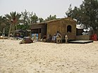 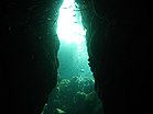   Clockwise from top: View of the sea, Under the sea, road from Al-Qusair to Safaga, Flag on beach, Camels for rides on the beach | |
 El Qoseir Location in Egypt | |
| Coordinates: 26°06′14″N 34°16′52″E / 26.10389°N 34.28111°E | |
| Country | |
| Governorate | Red Sea |
| Time zone | UTC+2 (EST) |
El Qoseir[note 1] (Arabic: القصير, romanized: el-Qoṣēr, pronounced [elʔoˈsˤeːɾ]) is a city in eastern Egypt, located on the Red Sea coast. Populated for approximately 5,000 years, its ancient name during the Ptolemaic era was Myos Hormos.[1] Historically, it was the endpoint of the Wadi Hammamat trail, an important route connecting Egypt and the Red Sea. El Qoseir is located 138 kilometers south of Hurghada, 130 km north of Marsa Alam and 68 km north of the Marsa Alam International Airport. In 1986, its population was approximately 20,000. Today, the population of El Qoseir is around 50,000.
Climate[]
|
|
Köppen-Geiger climate classification system classifies its climate as hot desert (BWh). Summers are hot and winters are warm. Winter night temperatures in El Qoseir, along with those of Marsa Alam and Sharm El Sheikh are the warmest of any other cities and resorts in Egypt. Additionally, Port Said, El Qoseir, Ras El Bar, Baltim, Damietta and Alexandria have the least temperature variation. Rain is very rare as in most of Egypt. Seasonal variation is small, comparable to Marsa Alam, but its summer days are cooler, even cooler than similar more northern areas at the Red Sea, like Hurghada and Sharm El Sheikh.
The highest record temperature was 46 °C (115 °F), recorded on July 12, 1983, while the coldest record temperature was 1 °C (34 °F), recorded on January 6, 1976.[4]
| hideClimate data for El Qoseir | |||||||||||||
|---|---|---|---|---|---|---|---|---|---|---|---|---|---|
| Month | Jan | Feb | Mar | Apr | May | Jun | Jul | Aug | Sep | Oct | Nov | Dec | Year |
| Record high °C (°F) | 30.4 (86.7) |
31.4 (88.5) |
38.3 (100.9) |
42.2 (108.0) |
44.6 (112.3) |
41.0 (105.8) |
37.6 (99.7) |
38.3 (100.9) |
36.4 (97.5) |
36.7 (98.1) |
32.8 (91.0) |
31.3 (88.3) |
44.6 (112.3) |
| Average high °C (°F) | 21.9 (71.4) |
22.6 (72.7) |
24.5 (76.1) |
27.1 (80.8) |
29.8 (85.6) |
31.8 (89.2) |
32.6 (90.7) |
32.7 (90.9) |
31.6 (88.9) |
29.3 (84.7) |
24.7 (76.5) |
23.2 (73.8) |
27.7 (81.9) |
| Daily mean °C (°F) | 17.8 (64.0) |
18.5 (65.3) |
20.5 (68.9) |
23.5 (74.3) |
26.4 (79.5) |
28.8 (83.8) |
29.6 (85.3) |
29.9 (85.8) |
28.3 (82.9) |
25.9 (78.6) |
22.5 (72.5) |
19.2 (66.6) |
24.2 (75.6) |
| Average low °C (°F) | 13.8 (56.8) |
14.3 (57.7) |
16.4 (61.5) |
19.7 (67.5) |
22.7 (72.9) |
25.4 (77.7) |
26.1 (79.0) |
26.4 (79.5) |
25.0 (77.0) |
22.4 (72.3) |
17.8 (64.0) |
15.5 (59.9) |
20.5 (68.9) |
| Record low °C (°F) | 9.0 (48.2) |
8.8 (47.8) |
9.2 (48.6) |
12.7 (54.9) |
16.6 (61.9) |
21.2 (70.2) |
21.3 (70.3) |
23.0 (73.4) |
18.1 (64.6) |
17.5 (63.5) |
12.4 (54.3) |
9.3 (48.7) |
8.8 (47.8) |
| Average precipitation mm (inches) | 0 (0) |
0 (0) |
0 (0) |
0 (0) |
0 (0) |
0 (0) |
0 (0) |
0 (0) |
0 (0) |
1 (0.0) |
1 (0.0) |
1 (0.0) |
3 (0.1) |
| Average precipitation days (≥ 1.0 mm) | 0 | 0 | 0.1 | 0.1 | 0 | 0 | 0 | 0 | 0 | 0.3 | 0.5 | 0 | 1.0 |
| Average relative humidity (%) | 51 | 48 | 50 | 50 | 48 | 48 | 50 | 51 | 54 | 56 | 54 | 54 | 51.2 |
| Mean daily sunshine hours | 9 | 10 | 10 | 10 | 11 | 13 | 13 | 12 | 11 | 10 | 10 | 9 | 11 |
| Source 1: NOAA,[5] Climate Charts[6] | |||||||||||||
| Source 2: Voodoo Skies for record temperatures,[4] Weather2Travel for sunshine[7] | |||||||||||||
| Jan | Feb | Mar | Apr | May | Jun | Jul | Aug | Sep | Oct | Nov | Dec |
|---|---|---|---|---|---|---|---|---|---|---|---|
| 23 °C (73 °F) | 22 °C (72 °F) | 22 °C (72 °F) | 23 °C (73 °F) | 25 °C (77 °F) | 26 °C (79 °F) | 28 °C (82 °F) | 29 °C (84 °F) | 28 °C (82 °F) | 27 °C (81 °F) | 26 °C (79 °F) | 24 °C (75 °F) |
See also[]
- Hurghada
- Marsa Alam
- Red Sea Riviera
Notes[]
- ^ Also spelled Kosseir, Al Qusair, El Quseir, Quseir, Qusseir or Qosseir.
References[]
- ^ Myos Hormos - Quseir al-Qadim: Roman and Islamic Ports on the Red Sea, Blue, Lucie, Peacock, David P. S.,Oxbow (2006)
- ^ Gauthier, Henri (1929). Dictionnaire des Noms Géographiques Contenus dans les Textes Hiéroglyphiques. 6. p. 64.
- ^ Gauthier, Henri (1929). Dictionnaire des Noms Géographiques Contenus dans les Textes Hiéroglyphiques. 6. p. 87.
- ^ Jump up to: a b "Quseir, Egypt". Voodoo Skies. Retrieved 13 August 2013.
- ^ "Kosseir Climate Normals 1961–1990". National Oceanic and Atmospheric Administration. Retrieved January 17, 2016.
- ^ "Kosseir, Egypt: Climate, Global Warming, and Daylight Charts and Data". Archived from the original on 19 August 2013. Retrieved 9 July 2013.
- ^ Jump up to: a b "El Quseir Climate and Weather Averages, Egypt". Weather2Travel. Retrieved 2014-01-06.
External links[]
| show Authority control |
|---|
- Populated places in Red Sea Governorate
- Underwater diving sites in Egypt