Extremes on Earth
This article needs additional citations for verification. (January 2008) |
This article lists extreme locations on Earth that hold geographical records or are otherwise known for their geophysical or meteorological superlatives. All of these locations are Earth-wide extremes; extremes of individual continents or countries are listed in separate articles under the Extreme points by region section. For other lists of extreme places on Earth, see Lists of extreme points. For more detailed meteorological and climatic records, see List of weather records.
Latitude and longitude[]
Northernmost[]
- The northernmost point on Earth is the Geographic North Pole, in the Arctic Ocean.
- The northernmost point on land is the northern tip of Kaffeklubben Island, north of Greenland (83°40′N 29°50′W / 83.667°N 29.833°W), which lies slightly north of Cape Morris Jesup, Greenland (83°38′N 32°40′W / 83.633°N 32.667°W). Various shifting gravel bars lie farther north, the most famous being Oodaaq. There have been other islands more northern such as 83-42 and ATOW1996 but they have not been confirmed as permanent.

Southernmost[]
- The southernmost point on Earth and the southernmost point on land is the Geographic South Pole, which is on the continent of Antarctica.
- The southernmost continental point of land outside Antarctica is in South America at Cape Froward, Magallanes Region, Chile (53°56′00″S 071°20′00″W / 53.93333°S 71.33333°W).
- The southernmost point of (liquid) water is a bay on the Filchner-Ronne Ice Shelf along the coast of Antarctica (83°S 59°W / 83°S 59°W)[citation needed], about 100 km (62 mi) south of Berkner Island.
- The southernmost point of ocean is located on the Gould Coast (84°30′S 150°0′W / 84.500°S 150.000°W).[citation needed][1]
- The southernmost point of open ocean is in the Bay of Whales, also part of the Ross Sea, at 78°30'S, at the edge of the Ross Ice Shelf.[2]
- The southernmost island is considered to be Deverall Island, near the Shackleton Coast, surrounded by the Ross Ice Shelf.
Easternmost and westernmost[]
- The easternmost and westernmost points on Earth, based on the east–west standard for describing longitude, can be found anywhere along the 180th meridian, which passes through the Arctic, Pacific, and Southern Oceans, as well as parts of Siberia (including Wrangel Island), Antarctica, and three islands of Fiji (Vanua Levu's eastern peninsula, the middle of Taveuni, and the western part of Rabi Island).
- Using instead the path of the International Date Line (which is not a straight line), the westernmost point on land is Attu Island, Alaska, and the easternmost point on land is Caroline Island, Kiribati.[a]
Longest grid lines[]
hideThis section has multiple issues. Please help or discuss these issues on the talk page. (Learn how and when to remove these template messages)
|
Along constant latitude[]
- The longest continuous east–west distance on land is 10,726 km (6,665 mi) along the latitude 48°24'53"N, from the west coast of France (Pointe de Corsen, 48°24′53″N 4°47′44″W / 48.41472°N 4.79556°W) through Central Europe, Ukraine, Russia, Kazakhstan, Mongolia and China, to a point on the east coast of Russia (48°24′53″N 140°6′3″E / 48.41472°N 140.10083°E).
- The longest continuous east–west distance at sea is 22,471 km (13,963 mi) along the latitude 55°59'S, south of Cape Horn, South America.
- The longest continuous east–west distance at sea between two continents is 15,409 km (9,575 mi) along the latitude 18°39'12"N, from the coast of Hainan, China (18°39′12″N 110°15′9″E / 18.65333°N 110.25250°E) across the Pacific Ocean to the coast of Michoacán, Mexico (18°39′12″N 103°42′6″W / 18.65333°N 103.70167°W).
Along constant longitude[]
- The longest continuous north–south distance on land is 7,590 km (4,720 mi) along the meridian 99°1'30"E, from the northern tip of Siberia in the Russian Federation (76°13′6″N 99°1′30″E / 76.21833°N 99.02500°E), through Mongolia, China, and Myanmar, to a point on the south coast of Thailand (7°53′24″N 99°1′30″E / 7.89000°N 99.02500°E).
- The longest in Africa is 7,417 km (4,609 mi) along the meridian 20°12'E, from the north coast of Libya (32°19′0″N 20°12′0″E / 32.31667°N 20.20000°E), through Chad, Central African Republic, Democratic Republic of the Congo, Angola, Namibia, and Botswana, to the south coast of South Africa (34°41′30″S 20°12′0″E / 34.69167°S 20.20000°E).
- The longest in South America is 7,098 km (4,410 mi) along the meridian 70°2'W, from the north coast of Venezuela (11°30′30″N 70°2′0″W / 11.50833°N 70.03333°W), through Colombia, Ecuador, Peru, and Chile, to the southern tip of Argentina (52°33′30″S 70°2′0″W / 52.55833°S 70.03333°W).
- The longest in North America is 5,813 km (3,612 mi) along the meridian 97°52'30"W, from northern Canada (68°21′0″N 97°52′30″W / 68.35000°N 97.87500°W), through the United States, to southern Mexico (16°1′0″N 97°52′30″W / 16.01667°N 97.87500°W).
- The longest continuous north–south distance at sea is 15,986 km (9,933 mi) along the meridian 34°45'45"W, from the coast of Eastern Greenland (66°23′45″N 34°45′45″W / 66.39583°N 34.76250°W) across the Atlantic Ocean to the Filchner-Ronne Ice Shelf, on the coast of Antarctica (77°37′0″S 34°45′45″W / 77.61667°S 34.76250°W). The longest in the Pacific Ocean is 15,883 km (9,869 mi) along the meridian 172°8'30"W, from the coast of Siberia (64°45′0″N 172°8′30″W / 64.75000°N 172.14167°W) to the Ross Ice Shelf in Antarctica (78°20′0″S 172°8′30″W / 78.33333°S 172.14167°W).
- The meridian that crosses the greatest total distance on land (disregarding intervening bodies of water) is still to be determined. It is likely located in the vicinity of 22°E, which is the longest integer meridian that fits that criterion, crossing a total of 13,035 km (8,100 mi) of land through Europe (3,370 km or 2,090 mi), Africa (7,458 km or 4,634 mi), and Antarctica (2,207 km or 1,371 mi).[b] More than 65% of this meridian's length is located on land. The next six longest integer meridians by total distance over land are, in order:
- 23°E: 12,953 km (8,049 mi) through Europe (3,325 km or 2,066 mi), Africa (7,415 km or 4,607 mi), and Antarctica (2,214 km or 1,376 mi)
- 27°E: 12,943 km (8,042 mi) through Europe (3,254 km or 2,022 mi), Asia (246 km or 153 mi), Africa (7,223 km or 4,488 mi), and Antarctica (2,221 km or 1,380 mi)
- 25°E: 12,875 km (8,000 mi) through Europe (3,344 km or 2,078 mi), Africa (7,327 km or 4,553 mi), and Antarctica (2,204 km or 1,370 mi)
- 26°E: 12,858 km (7,990 mi) through Europe (3,404 km or 2,115 mi), Africa (7,258 km or 4,510 mi), and Antarctica (2,196 km or 1,365 mi)
- 24°E: 12,794 km (7,950 mi) through Europe (3,263 km or 2,028 mi), Africa (7,346 km or 4,565 mi), and Antarctica (2,185 km or 1,358 mi)
- 28°E: 12,778 km (7,940 mi) through Europe (3,039 km or 1,888 mi), Asia (388 km or 241 mi), and Africa (7,117 km or 4,422 mi)
Along any geodesic[]
These are the longest straight lines[c] that can be drawn between any two points on the surface of the Earth and remain exclusively over land or water; the points need not lie on the same line of latitude or longitude.
- The longest continuous straight-line (great circle) path over land is between Jinjiang, Fujian, China, and near Sagres, Portugal, at 11,241 km (6,985 mi).[3] A longer line meeting the same criteria has also been suggested: at 13,573 km (8,434 mi), it begins on the West African coast near Greenville, Liberia (5°2′51.59″N 9°7′23.26″W / 5.0476639°N 9.1231278°W), passes over the Suez Canal, and ends at the top of a peninsula approximately 100 km (62 mi) northeast of Wenzhou, China (28°17′7.68″N 121°38′17.31″E / 28.2854667°N 121.6381417°E).[4]
- The longest continuous straight-line land distance solely within continental Africa is 8,402 km (5,221 mi), along a line that begins just east of Tangier, Morocco, and ends 100 km (62 mi) east of Port Elizabeth, South Africa. This line passes through Morocco, Algeria, Mali, Niger, Nigeria, Cameroon, Equatorial Guinea, Gabon, Republic of the Congo, Democratic Republic of the Congo, Angola, Namibia, Botswana, and South Africa.[citation needed]
- The longest continuous straight-line land distance solely within continental Asia is 10,152 km (6,308 mi), along a line that begins on the Indian coast near Kanyakumari and ends at the Bering Sea coast of the Chukchi Peninsula in Russia. This line passes through India, Nepal, China, Mongolia, and Russia.[citation needed]
- The longest continuous straight-line land distance solely within continental Europe (defining the Ural Mountains as the border between Europe and Asia) is 5,325 km (3,309 mi), along a line that begins at Cape St. Vincent, Portugal, and ends at the Urals, near the town of Perm, Russia. This line passes through Portugal, Spain, France, Germany, Poland, Lithuania, Belarus, and Russia.[citation needed]
- The longest continuous straight-line land distance solely within continental North America is 7,602 km (4,724 mi), along a line that begins at Point Hope, Alaska, United States, and ends 34 km (21 mi) southwest of the town of Salina Cruz, Mexico. This line passes through Alaska, Canada, the contiguous United States, and Mexico.[citation needed]
- The longest continuous straight-line land distance solely within continental South America is 7,248 km (4,504 mi), along a line that begins 10 km (6.2 mi) northeast of Puerto Cumarebo, Venezuela, and ends 80 km (50 mi) south of the town of Punta Arenas, Chile. This line passes through Venezuela, Colombia, Brazil, Peru, Chile, and Argentina.[citation needed]
- The longest continuous straight-line land distance solely within continental Australia is 4,053 km (2,518 mi), along a line that begins at the southern end of Cape Range National Park in Western Australia and ends at the town of Byron Bay in New South Wales.[citation needed]
- There are several possible candidates for the longest continuous straight-line distance in any direction at sea, as there are many possible ways to travel along a great circle for more than the antipodic length of 19,840 km (12,330 mi). Some examples of such routes would be:
- From the south coast of Balochistan province somewhere near Port of Karachi, Pakistan (25°25′N 66°25′E / 25.417°N 66.417°E) across the Arabian Sea, southwest through the Indian Ocean, near Comoros, passing Namaete Canyon, near the South African coast, across the South Atlantic Ocean, then west across Cape Horn, then northwest across the Pacific Ocean, near Easter Island, passing the antipodal point near Amlia island, through the South Bering Sea and ending somewhere on the northeast coast of Kamchatka, near Ossora (59°38′N 163°24′E / 59.633°N 163.400°E). This route is 32,040 km (19,910 mi) long.[5] This route was confirmed to be the longest (at about 32090 km) given map data at a 1.8 km level of resolution.[6][7]
- From the south coast of Hormozgan province, Iran (25°35′N 58°22′E / 25.583°N 58.367°E) across the Gulf of Oman, southeast across the Arabian Sea, passing south of Australia and New Zealand, near the Antarctic coast, then northeast across the South Pacific Ocean, passing the antipodal point and ending on the southwest coast of Mexico somewhere near (17°57′N 101°57′W / 17.950°N 101.950°W). This route is 25,267 km (15,700 mi) long.[8]
- From Invercargill, New Zealand (46°37′S 168°59′E / 46.617°S 168.983°E) across Cape Horn, then off the coast of Brazil close to Recife, passing north of Cape Verde, passing the antipodal point and ending somewhere on the southwest coast of Ireland (52°09′N 6°34′W / 52.150°N 6.567°W). This route is 20,701 km (12,863 mi) long.[9]
Along any truly straight line[]
As distinct from all of the aforementioned geodesic lines, which may appear straight but are actually arcs of great circles projected on the spheroidal surface of the Earth and, accordingly, are not truly straight but rather curving lines, authentically straight lines can be projected through the interior of the Earth between almost any two points on the surface of the Earth (some extreme topographical situations being the rare exceptions). If a line projected from the summit of Cayambe in Ecuador (see highest points) through the axial centre of the Earth to its antipode on the island of Sumatra, then the resulting diametrical line would be the longest truly straight line that could be produced anywhere on or through the Earth. As the variable circumference of the Earth approaches 40,000 kilometres (25,000 mi), such a maximum "diametrical" or "antipodal" line would be on the order of 13,000 kilometres (8,000 mi) long.
Elevation[]
Highest points[]
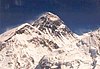
- The highest point on Earth's surface measured from sea level is the summit of Mount Everest, on the border of Nepal and China. While measurements of its height vary slightly, the elevation of its peak was most recently established in 2020 by the Nepali and Chinese authorities as 8,848.86 m (29,032 ft) above sea level.[10] The summit was first reached by Sir Edmund Hillary of New Zealand and Tenzing Norgay Sherpa of Nepal in 1953.
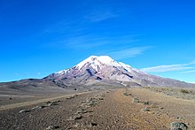
- The point farthest from Earth's centre is the summit of Chimborazo[11] in Ecuador, at 6,384.4 km (3,967.1 mi) from Earth's centre; the peak's elevation relative to sea level is 6,263.47 m (20,549 ft).[d] Because Earth is an oblate spheroid rather than a perfect sphere, it is wider at the equator and narrower toward each pole. Therefore, the summit of Chimborazo, which is near the Equator, is farther away from Earth's centre than the summit of Mount Everest is; the latter is 2,168 m (7,112.9 ft) closer, at 6,382.3 km (3,965.8 mi) from Earth's centre. Peru's Huascarán (at 6,768 m or 22,205 ft) contends closely with Chimborazo, the difference in the mountains' heights being just 23 m (75 ft).
- The fastest point on Earth or, in other words, the point furthest from Earth's rotational axis is the summit of Cayambe[13] in Ecuador, which revolves around Earth's axis at a speed of 1,675.89 km/h (1,041.35 mph) and is 6,383.95 km (3,966.80 mi) from the axis. Like Chimborazo, which is the fourth fastest peak at 1,675.47 km/h (1,041.09 mph), Cayambe is close to the Equator and takes advantage of the oblate spheroid figure of Earth. More importantly, however, it being so near the Equator means that the majority of its distance from Earth's centre goes into it being away from the axis.
Highest geographical features[]
- The highest volcano is Ojos del Salado on the Argentina–Chile border. It has the highest summit, 6,893 m (22,615 ft), of any volcano on Earth.
- The highest natural lake is an unnamed crater lake on Ojos del Salado at 6,390 m (20,965 ft),[14] on the Argentina side. Another candidate was Lhagba Pool on the northeast slopes of Mount Everest, Tibet, at an elevation of 6,368 m (20,892 ft), which has since dried up.[15]
- The highest navigable lake is Lake Titicaca, on the border of Bolivia and Peru in the Andes, at 3,812 m (12,507 ft).
- The highest glacier is the Khumbu Glacier on the southwest slopes of Mount Everest in Nepal, beginning on the west side of Lhotse at an elevation of 7,600 to 8,000 m (24,900 to 26,200 ft).[16]
- The highest river is disputed; one candidate from many possibilities is the , which flows into the (Hagung Tso), a large lake in Tibet, and has an elevation of about 6,100 m (20,013 ft) at its source at 32°49′30″N 81°03′45″E / 32.82500°N 81.06250°E. Another very large and high river is the Yarlung Tsangpo or upper Brahmaputra River in Tibet, whose main stem, the Maquan River, has its source at about 6,020 m (19,751 ft) above sea level at 30°48′59″N 82°42′45″E / 30.81639°N 82.71250°E.[17] Above these elevations, there are no constantly flowing rivers since the temperature is almost always below freezing.
- The highest island is one of a number of islands in the Orba Co lake in Tibet, at an elevation of 5,209 m (17,090 ft).[18]
Highest points attainable by transportation[]
- The highest point accessible...
- ...by land vehicle is an elevation of 6,688 m (21,942 ft) on Ojos del Salado in Chile, which was reached by the Chilean duo of Gonzalo and Eduardo Canales Moya on 21 April 2007 with a modified Suzuki Samurai, setting the high-altitude record for a four-wheeled vehicle.
- ...by road (dead end) is on a mining road to the summit of Aucanquilcha in Chile, which reaches an elevation of 6,176 m (20,262 ft). It was once usable by 20-tonne mining trucks.[19] The road is no longer usable. 21°12′50″S 68°28′30″W / 21.214°S 68.475°W
- ...by road (mountain pass) is disputed; there are a number of competing claims for this title due to the definition of "motorable pass" (i.e. a surfaced road or one simply passable by a vehicle):
- The highest asphalted road crosses Tibet's Semo La pass at 5,565 m (18,258 ft). It is used by trucks and buses regularly.[20] The Ticlio pass, on the Central Road of Peru, is the highest surfaced road in the Americas, at an elevation of 4,818 m (15,807 ft).
- The highest unsurfaced road has several different claimants. All are unsurfaced or gravel roads including the barely passable road to Umling, LA, 17 km (11 mi) west of Demchok in Ladakh, India, which reaches 5,800 m (19,029 ft) ("19,300 feet" according to a Border Roads Organisation sign there that recognizes it as the "World's Highest Motorable Pass"),[21] and Mana Pass, between India and Tibet, which is crossed by a gravel road reaching 5,610 m (18,406 ft). The heavily trafficked Khardung La in Ladakh lies at 5,359 m (17,582 ft). A possibly motorable gravel road crosses Marsimik La in Ladakh at 5,582 m (18,314 ft).
- ...by train is Tanggula Pass, located on the Qinghai–Tibet (Qingzang) Railway in the Tanggula Mountains of Qinghai/Tibet, China, at 5,072 m (16,640 ft). The Tanggula railway station is the world's highest railway station at 5,068 m (16,627 ft). Before the Qingzang Railway was built, the highest railway ran between Lima and Huancayo in Peru, reaching 4,829 m (15,843 ft) at Ticlio.[22]
- ...by oceangoing vessel is a segment of the Rhine–Main–Danube Canal between the Hilpoltstein and Bachhausen locks in Bavaria, Germany. The locks artificially raise the surface level of the water in the canal to 406 m (1,332 ft) above mean sea level, higher than any other lock system in the world, making it the highest point currently accessible by oceangoing commercial watercraft.

- The highest commercial airport is Daocheng Yading Airport, Sichuan, China, at 4,411 m (14,472 ft).[23] The proposed Nagqu Dagring Airport in Tibet, if built, will be 25 m (82 ft) higher at 4,436 m (14,554 ft).
- The highest helipad is Sonam, Siachen Glacier, India, at a height of 6,400 m (20,997 ft) above sea level.[24]
- The highest permanent human settlement is La Rinconada, Peru, 5,100 m (16,732 ft), in the Peruvian Andes.
- The farthest road from the Earth's centre is the Road to Carrel Hut in the Ecuadorian Andes, at an elevation of 4,850 m (15,912 ft) above sea level and a distance of 6,382.9 km (3,966 mi) from the centre of the Earth.[25]
Lowest points[]
Lowest natural points[]
- The lowest point on Earth's surface is Challenger Deep, at the bottom of the Mariana Trench, 11,034 m (36,201 ft) below sea level.[26] Only six humans have reached the bottom of the trench: Jacques Piccard and U.S. Navy Lieutenant Don Walsh in 1960 aboard the bathyscaphe Trieste, filmmaker James Cameron in 2012 aboard Deepsea Challenger, as well as Victor Vescovo, Patrick Lahey, and Jonathan Struwe aboard the DSV Limiting Factor in 2019.[27]
- The lowest point underground is in the Krubera Cave in Abkhazia, where the altitude difference between the cave's entrance and the deepest explored point (the maximum depth) is 2,191 ± 20 m (7,188 ± 66 ft). In 2012, Ukrainian cave diver Gennadiy Samokhin reached the lowest point, breaking the world record.[28]
- The lowest point on land not covered by liquid water is the canyon under Denman Glacier in Antarctica, with the bedrock being 3,500 m (11,500 ft) below sea level.[29][30]
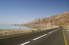
- The lowest point on dry land is the shore of the Dead Sea, shared by Israel, Palestine, and Jordan, 432.65 m (1,419 ft) below sea level. As the Dead Sea waters are receding, the water surface level drops more than 1 metre (3.3 ft) per year.[31]
- The point on the surface closest to the Earth's centre (interpreted as a natural surface of the land or sea that is accessible by a person) is the surface of the Arctic Ocean at the Geographic North Pole (6,356.77 km or 3,950 mi).
- The point on the ground closest to the Earth's centre (interpreted as a land surface or sea floor) is the bottom of the Litke Deep, which is 6,351.61 km (3,947 mi) from the centre of the Earth.[citation needed] By comparison, the bottom of the deepest oceanic trench in the world, the Mariana Trench in the Pacific Ocean, is 14.7 km (9 mi) farther from the centre of the Earth.
Lowest artificial points[]
- The lowest point underground ever reached was 12,262 m (40,230 ft) deep (SG-3 at the Kola Superdeep Borehole, which has since been enclosed).
- The lowest human-sized point underground is 3,900 m (12,800 ft)[32] below ground at the TauTona Mine, Carletonville, South Africa.
- The lowest (from sea level) artificially made point with open sky may be the Hambach surface mine, Germany, which reaches a depth of 293 m (961 ft) below sea level.
- The lowest (from surface) artificially made point with open sky may be the Bingham Canyon open-pit mine, Salt Lake City, United States, at a depth of 1,200 m (3,900 ft) below surface level.
- The lowest point underwater is the 10,685 m (35,056 ft)-deep (as measured from the subsea wellhead) oil and gas well drilled on the Tiber Oil Field in the Gulf of Mexico. The wellhead of this well is an additional 1,259 m (4,131 ft) underwater, for a total distance of 11,944 m (39,186 ft) as measured from sea level.[33]28°44′12″N 88°23′13″W / 28.736667°N 88.386944°W
Lowest points attainable by transportation[]
- The lowest point accessible...
- ...by road, excluding roads in mines, is any of the roads alongside the Dead Sea in Israel and Jordan, which are the lowest on Earth at 418 m (1,371 ft) below sea level.
- The lowest undersea highway tunnel is the Ryfast tunnel in Norway, at 292 m (958 ft) below sea level.
- ...by train, excluding tracks in mines, is located in the Seikan Tunnel in Japan, at 240 m (787 ft) below sea level. For comparison, the undersea Channel Tunnel between England and France reaches a depth of 115 m (377 ft) below sea level.
- Some mines have roads accessible from outside or rail tracks, located more than two thousand metres below sea level, for example in some South African gold mines.
- ...by road, excluding roads in mines, is any of the roads alongside the Dead Sea in Israel and Jordan, which are the lowest on Earth at 418 m (1,371 ft) below sea level.
- The lowest railroad station was formerly the Japanese Yoshioka-Kaitei Station, at 150 m (492 ft) below sea level, but it closed in 2014. The lowest railroad station not inside a tunnel is 120 m (394 ft) below sea level, at Beit She'an railway station in Israel.[citation needed]
- The lowest airfield is the Bar Yehuda Airfield, near Masada, Israel, at 378 m (1,240 ft) below sea level.
- The lowest international airport is Atyrau Airport, near Atyrau, Kazakhstan, at 22 m (72 ft) below sea level, in the basin of the Caspian Sea.
- The lowest major city is Baku, Azerbaijan, located 28 m (92 ft) below sea level, which makes it the lowest-lying national capital in the world and also the largest city in the world located below sea level.
Table of extreme elevations and air temperatures by continent[]
| Continent | Elevation (height above/below sea level)A | Air temperature (recorded)[34]B | |||
| Highest | Lowest | Highest | Lowest | ||
| Africa | 5,893 m (19,334 feet) Kilimanjaro, Tanzania[35] |
−155 m (−509 feet) Lake Assal, Djibouti[36] |
55 °C (131 °F) Kebili, French Tunisia 7 July 1931C |
−23.9 °C (−11.0 °F) Ifrane, French Morocco 11 February 1935 | |
| Antarctica | 4,892 m (16,050 feet) Vinson Massif[37] |
 |
−50 m (−164 feet)[38] Deep Lake, Vestfold Hills (compare the deepest ice section below) |
20.75 °C (69.35 °F) Comandante Ferraz Antarctic Station 9 February 2020 |
−89.2 °C (−128.6 °F) Vostok Station 21 July 1983 |
| Asia | 8,848.86 m (29,032 feet) Mount Everest, Tibet-Nepal Border [39] |
 |
−424 m (−1,391 feet) Dead Sea, Israel-Jordan-Palestine[40] |
54 °C (129 °F) Tirat Zvi, Israel (then in the British Mandate of Palestine) 21 June 1942 |
−67.7 °C (−89.9 °F) Measured Oymyakon, Siberia, Soviet Union 6 February 1933[41][42] |
| 54 °C (129 °F) Ahvaz Airport, Iran 29 June 2017[43] |
−71.2 °C (−96.2 °F) Extrapolated Oymyakon, Siberia, Soviet Union 26 January 1926[44] | ||||
| Europe | 5,642 m (18,510 feet) Mount Elbrus, Russian Federation[45] |
 |
−28 m (−92 feet) Caspian Sea shore, Russian Federation[46] |
48.0 °C (118.4 °F) Athens, Greece (and Elefsina, Greece) 10 July 1977 E |
−58.1 °C (−72.6 °F) Ust-Shchuger, Soviet Union 31 December 1978 |
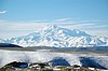
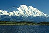
| North America | 6,190.5 m (20,310 feet) Denali (Mount McKinley), Alaska, United States[47] |
 |
−85 m (−279 feet) Badwater Basin, California, United States[48] |
56.7 °C (134 °F) Greenland Ranch (Furnace Creek), California, United States 10 July 1913C |
−66.1 °C (−87.0 °F) North Ice, Greenland 9 January 1954F |
| Oceania | 4,884 m (16,024 feet) Puncak Jaya (Carstensz Pyramid), Indonesia (compare Mount Wilhelm, Mount Cook and Mount Kosciuszko)[49] |
 |
−15 m (−49 feet) Lake Eyre, South Australia, Australia[50] |
50.7 °C (123.3 °F) Oodnadatta, South Australia, Australia 2 January 1960G |
−25.6 °C (−14.1 °F) Ranfurly, Otago, New Zealand 17 July 1903 |
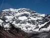
| South America | 6,962 m (22,841 feet) Aconcagua, Mendoza, Argentina[51] |
 |
−105 m (−344 feet) Laguna del Carbón, Argentina[52] |
48.9 °C (120.0 °F) Rivadavia, Salta Province, Argentina 11 December 1905 |
−32.8 °C (−27.0 °F) Sarmiento, Chubut Province, Argentina 1 June 1907 |
| |||||
Remoteness[]
Poles of inaccessibility[]
Each continent has its own continental pole of inaccessibility, defined as the place on the continent that is farthest from any ocean. Similarly, each ocean has its own oceanic pole of inaccessibility, defined as the place in the ocean that is farthest from any land.
Continental[]
- The most distant point from an ocean is the Eurasian Pole of Inaccessibility (or "EPIA") 46°17′N 86°40′E / 46.283°N 86.667°E, in China's Xinjiang region near the border with Kazakhstan. Calculations have shown that this point, located in the Dzoosotoyn Elisen Desert, is 2,645 km (1,644 mi) from the nearest coastline. The nearest settlement to the EPIA is Suluk at 46°15′N 86°50′E / 46.250°N 86.833°E, about 11 km (6.8 mi) to the east.[citation needed] A 2007 study suggests that the historical calculation of the EPIA failed to recognize the point where the Gulf of Ob joins the Arctic Ocean, and proposes instead that varying definitions of coastline could result in other locations for the EPIA:
- EPIA1, somewhere between 44°17′N 82°11′E / 44.283°N 82.183°E and 44°29′N 82°19′E / 44.483°N 82.317°E, is about 2,510 ± 10 km (1,559.6 ± 6.2 mi) from the nearest ocean.
- EPIA2, somewhere between 45°17′N 88°08′E / 45.283°N 88.133°E and 45°28′N 88°14′E / 45.467°N 88.233°E, is about 2,514 ± 7 km (1,562.1 ± 4.3 mi) from the nearest ocean.[58]
- If adopted, this would place the final EPIA roughly 130 km (81 mi) closer to the ocean than the point that is currently agreed upon.[58] Coincidentally, EPIA1, or EPIA2, and the most remote of the Oceanic Pole of Inaccessibility (specifically, the point in the South Pacific Ocean that is farthest from land) are similarly remote; EPIA1 is less than 200 km (120 mi) closer to the ocean than the Oceanic Pole of Inaccessibility is to land.
- The continental poles of inaccessibility for the other continents are as follows:
- Africa: 5°39′N 26°10′E / 5.65°N 26.17°E,[58] close to the tripoint of the Central African Republic, South Sudan, and the Democratic Republic of the Congo
- Australia: either 23°2′S 132°10′E / 23.033°S 132.167°E,[59] or 23°10′S 132°16′E / 23.17°S 132.27°E,[58] near Papunya, Northern Territory
- North America: 43°22′N 101°58′W / 43.36°N 101.97°W,[58] between Kyle, South Dakota and Allen, South Dakota, United States.
- South America: 14°03′S 56°51′W / 14.05°S 56.85°W,[58] near Arenápolis, Mato Grosso, Brazil
Oceanic[]
- The most distant point from land is the Pacific pole of inaccessibility (also called "Point Nemo"), which lies in the South Pacific Ocean at 48°52.6′S 123°23.6′W / 48.8767°S 123.3933°W, approximately 2,688 km (1,670 mi) from the nearest land (equidistant from Ducie Island in the Pitcairn Islands to the north, Motu Nui off Rapa Nui to the northeast, and Maher Island off Siple Island near Marie Byrd Land, Antarctica, to the south).[60]
Other places considered the most remote[]

- The most remote island is Bouvet Island, a small, uninhabited island in the South Atlantic Ocean that is a dependency of Norway. It lies at coordinates 54°26′S 3°24′E / 54.433°S 3.400°E. The nearest land is the uninhabited Queen Maud Land, Antarctica (also claimed by Norway), over 1,600 km (994 mi) to the south. The nearest inhabited lands are Gough Island, 1,845 km (1,146 mi) away, Tristan da Cunha, 2,260 km (1,404 mi) away, and the coast of South Africa, 2,580 km (1,603 mi) away.
- The title for most remote inhabited island or archipelago (the farthest away from any other permanently inhabited place) depends on how the question is interpreted. If the south Atlantic island Tristan da Cunha (population about 300) and its dependency Gough Island (with a small staffed research post), which are 399 km (248 mi) from each other, are considered part of the same archipelago, or if Gough Island is not counted because it has no permanent residents, then Tristan da Cunha is the world's most remote inhabited island/archipelago: the main island, also called Tristan da Cunha, is 2,434 km (1,512 mi) from the island Saint Helena, 2,816 km (1,750 mi) from South Africa, and 3,360 km (2,090 mi) from South America. It is 2,260 km (1,404 mi) away from uninhabited Bouvet Island. However, if Gough and Tristan da Cunha are considered separately, they disqualify each other, and the most remote inhabited island is Easter Island in the South Pacific Ocean, which lies 2,075 km (1,289 mi) from Pitcairn Island (about 50 residents in 2013), 2,606 km (1,619 mi) from Rikitea on the island of Mangareva (the nearest town with a population over 500), and 3,512 km (2,182 mi) from the coast of Chile (the nearest continental point and the country of which Easter Island is part). The Kerguelen Islands in the southern Indian Ocean are another contender, lying 1,340 km (830 mi) from the small Alfred Faure scientific station in Île de la Possession, but otherwise more than 3,300 km (2,100 mi) from the coast of Madagascar (the nearest permanently inhabited place), 450 km (280 mi) northwest of the uninhabited Heard Island and McDonald Islands (both a part of Australia), and 1,440 km (890 mi) from the non-permanent scientific station located in Île Amsterdam.
- The most remote city...
- ...with a population in excess of one million from the nearest city with a population in excess of one million is Auckland, New Zealand. The nearest city of comparable size or greater is Sydney, Australia, 2,168.9 km (1,347.7 mi) away.[61]
- ...with a population in excess of one million from the nearest city with a population above 100,000 is Perth, Australia, located 2,138 km (1,328 mi)[62] away from Adelaide, Australia.
- ...with a population in excess of 100,000 from the nearest city of at least that population is Honolulu, Hawaii, United States. The nearest city of comparable size or greater is San Francisco, 3,850 km (2,390 mi) away.[63]
- ...that is a national capital from the nearest national capital is a tie between Wellington, New Zealand, and Canberra, Australia, which are 2,326 km (1,445 mi) apart from each other.
- The most remote airport in the world from another airport is Mataveri International Airport (IPC) on Easter Island, which has a single runway for military and public use. It is located 2,603 km (1,617 mi) from Totegegie Airport (GMR; very few flights) in the Gambier Islands, French Polynesia and 3,759 km (2,336 mi) from Santiago, Chile (SCL; a fairly large airport). In comparison, the airport at the Amundsen–Scott South Pole Station (NZSP) is not very remote at all, being located only 1,355 km (842 mi) from Williams Field (NZWD) near Ross Island.[64]
Farthest-apart cities[]
The pairs of cities (with a population over 100,000) with the greatest distance between them (antipodes) are:[65]
- Rosario, Argentina to Xinghua, China: 19,996 km (12,425 mi)[66]
- Lu'an, China to Río Cuarto, Argentina: 19,994 km (12,424 mi)[67]
- Cuenca, Ecuador to Subang Jaya, Malaysia: 19,989 km (12,421 mi)[68]
- Shanghai, China to Concordia, Argentina: 19,984 km (12,417 mi)[69]
- Rancagua, Chile to Xi'an, China: 19,972 km (12,410 mi)[70]
- Resistencia, Argentina to Rui'an, China: 19,967 km (12,407 mi)[71]
- Yantai, China to Tandil, Argentina: 19,965 km (12,406 mi)[72]
- Coquimbo, Chile to Lichuan, China: 19,964 km (12,405 mi)[73]
- Bandung, Indonesia to Piedecuesta, Colombia: 19,962 km (12,404 mi)[74]
- Salamanca, Spain to Lower Hutt, New Zealand: 19,961 km (12,403 mi)[75]
The pair of airports with scheduled flights having the greatest distance between them has been measured to be Sultan Mahmud Badaruddin II International Airport, which serves Palembang, Indonesia, and Benito Salas Airport, which serves Neiva, Colombia, located about 10,819 nautical miles (20,037 km) apart.[76]
Centre[]
Since the Earth is a spheroid, its centre (the core) is thousands of kilometres beneath its crust. Still, there have been attempts to define various "centrepoints" on the Earth's surface.
- The centre of the standard geographic model as viewed on a traditional world map is the point 0°, 0° (the coordinates of zero degrees latitude by zero degrees longitude), which is located in the Atlantic Ocean approximately 614 km (382 mi) south of Accra, Ghana, in the Gulf of Guinea. It lies at the intersection of the Equator and the Prime Meridian, is marked with a buoy and sometimes called Null Island. However, the selection of the Prime Meridian as the 0° longitude meridian depended on cultural and historical factors and is therefore geographically arbitrary (any of the Earth's meridians could, in principle, be defined as 0° longitude); consequently, the position of the "Null Island" centrepoint is also arbitrary.
- The centre of population, the place to which there is the shortest average route for every individual human being in the world, could also be considered a "centre of the world". This point is located in the north of the Indian subcontinent, although the precise location has never been calculated and is constantly shifting due to changes in the distribution of the human population across the planet.
Geophysical extremes[]
Greatest vertical drop[]
| Greatest purely vertical drop | 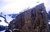 Mount Thor, Auyuittuq National Park, Baffin Island, Nunavut, Canada (summit elevation 1,675 m (5,495 ft))[77][78] |
| Greatest nearly vertical drop |  Trango Towers, Gilgit-Baltistan, Pakistan (summit elevation 6,286 m (20,623 ft)) |
Subterranean[]
| Deepest mine below ground level | 4,000 m (13,123 ft) Mponeng Gold Mine, Gauteng Province, South Africa |
| Deepest mine below sea level | 2,733 m (8,967 ft) below sea level Kidd Mine, Ontario, Canada |
| Deepest open-pit mine below ground level | 1,200 m (3,937 ft) Bingham Canyon Mine, Utah, United States |
| Deepest open-pit mine below sea level | 293 m (961 ft) below sea level Tagebau Hambach, Germany |
| Deepest cave (measured from the entrance) | 2,204 m (7,231 ft) Veryovkina, Arabika Massif, Abkhazia, Georgia[79] |
| Deepest pitch (single vertical drop) | 1,026 m (3,366 ft) , China[80] |
| Deepest borehole | 12,261 m (40,226 ft) Kola Superdeep Borehole, Russia[81] |
Greatest oceanic depths[]
| Atlantic Ocean | 8,376 m (27,480 ft)[82] Milwaukee Deep (within the Brownson Deep), Puerto Rico Trench |
| Arctic Ocean | 5,550 m (18,209 ft)[83] Molloy Deep, Fram Strait |
| Indian Ocean | 7,192 m (23,596 ft)[84] Sunda Trench |
| Mediterranean Sea | 5,267 m (17,280 ft) Calypso Deep, Hellenic Trench |
| Pacific Ocean | 10,928 m (35,853 ft)[85] Challenger Deep, Mariana Trench[86] |
| Southern Ocean | 7,433.6 m (24,388 ft)[87] South Sandwich Trench (southernmost portion, at 60°28.46′S 025°32.32′W / 60.47433°S 25.53867°W) |
Deepest ice[]
Ice sheets on land, but having the base below sea level. Places under ice are not considered to be on land.
| Bentley Subglacial Trench | −2,555 m (−8,383 ft) | Antarctica |
| Trough beneath Jakobshavn Isbræ | −1,512 m (−4,961 ft)[88] | Greenland, Denmark |
Meteorological extremes[]
Coldest and hottest inhabited places on Earth[]
| Hottest inhabited place | Dallol, Ethiopia (Amharic: ዳሎል), whose annual mean temperature was recorded from 1960 to 1966 as 34.4 °C (93.9 °F).[89] The average daily maximum temperature during the same period was 41.1 °C (106.0 °F).[90] |
| Coldest inhabited place | Oymyakon (Russian: Оймяко́н), a rural locality (selo) in Oymyakonsky District of the Sakha Republic, the Russian Federation, has the coldest monthly mean, with −46.4 °C (−51.5 °F) the average temperature in January, the coldest month. Eureka, Nunavut, Canada has the lowest annual mean temperature at −19.7 °C (−3.5 °F).[91] |
| The South Pole and some other places in Antarctica are colder and are populated year-round, but almost everyone stays less than a year and could be considered visitors, not inhabitants. |
Ground temperatures[]
Temperatures measured directly on the ground may exceed air temperatures by 30 to 50 °C.[92] A ground temperature of 84 °C (183.2 °F) has been recorded in Port Sudan, Sudan.[93] A ground temperature of 93.9 °C (201 °F) was recorded in Furnace Creek, Death Valley, California, United States on 15 July 1972; this may be the highest natural ground surface temperature ever recorded.[94] The theoretical maximum possible ground surface temperature has been estimated to be between 90 and 100 °C for dry, darkish soils of low thermal conductivity.[95]
Satellite measurements of ground temperature taken between 2003 and 2009, taken with the MODIS infrared spectroradiometer on the Aqua satellite, found a maximum temperature of 70.7 °C (159.3 °F), which was recorded in 2005 in the Lut Desert, Iran. The Lut Desert was also found to have the highest maximum temperature in 5 of the 7 years measured (2004, 2005, 2006, 2007 and 2009). These measurements reflect averages over a large region and so are lower than the maximum point surface temperature.[92]
Satellite measurements of the surface temperature of Antarctica, taken between 1982 and 2013, found a coldest temperature of −93.2 °C (−136 °F) on 10 August 2010, at 81°48′S 59°18′E / 81.8°S 59.3°E. Although this is not comparable to an air temperature, it is believed that the air temperature at this location would have been lower than the official record lowest air temperature of −89.2 °C.[96][97]
Extreme points by region[]
Afro-Eurasia[]
- Extreme points of Afro-Eurasia
- Africa
- Algeria
- Angola
- Benin
- Botswana
- Burkina Faso
- Burundi
- Cameroon
- Cape Verde
- Central African Republic
- Chad
- Comoros
- Democratic Republic of the Congo
- Republic of Congo
- Côte d'Ivoire
- Djibouti
- Egypt
- Equatorial Guinea
- Eritrea
- Ethiopia
- Gabon
- Gambia
- Ghana
- Guinea
- Guinea-Bissau
- Kenya
- Lesotho
- Liberia
- Libya
- Madagascar
- Malawi
- Mali
- Mauritania
- Mauritius
- Morocco
- Mozambique
- Namibia
- Niger
- Nigeria
- Rwanda
- São Tomé and Príncipe
- Senegal
- Seychelles
- Sierra Leone
- Somalia
- South Africa
- Sudan
- South Sudan
- Swaziland
- Tanzania
- Togo
- Tunisia
- Uganda
- Western Sahara
- Zambia
- Zimbabwe
- Eurasia
- Asia
- Afghanistan
- Armenia
- Azerbaijan
- Bangladesh
- Bhutan
- Cambodia
- China
- Georgia
- India
- Indonesia
- Iran
- Israel
- Japan
- Jordan
- Kazakhstan
- Kyrgyzstan
- Laos
- Malaysia
- Maldives
- Mongolia
- Myanmar
- Nepal
- North Korea
- Pakistan
- Philippines
- Russia
- Singapore
- South Korea
- Sri Lanka
- Taiwan
- Tajikistan
- Thailand
- Turkey
- Turkmenistan
- Uzbekistan
- Vietnam
- Europe
- European Union
- Albania
- Andorra
- Austria
- Belarus
- Belgium
- Bosnia and Herzegovina
- Bulgaria
- Croatia
- Czech Republic
- Denmark
- Estonia
- Finland
- France
- Germany
- Greece
- Hungary
- Iceland
- Ireland
- Italy
- Kosovo
- Latvia
- Liechtenstein
- Lithuania
- Luxembourg
- Malta
- Moldova
- Monaco
- Montenegro
- Netherlands
- North Macedonia
- Norway
- Poland
- Portugal
- Romania
- Russia
- San Marino
- Serbia
- Slovakia
- Slovenia
- Spain
- Sweden
- Switzerland
- Ukraine
- United Kingdom
- Vatican City
- Asia
- Africa
The Americas[]
- Extreme points of the Americas
- North America
- Canada (provinces, communities)
- Greenland
- Mexico
- United States (states, New England)
- Central America
- Belize
- Costa Rica
- El Salvador
- Guatemala
- Honduras
- Nicaragua
- Panama
- The Caribbean
- Cuba
- Jamaica
- South America
- North America
Oceania[]
- Extreme points of Oceania
- Australia
- Fiji
- Guam
- Indonesia
- Kiribati
- Marshall Islands
- Micronesia
- Nauru
- New Zealand
- Niue
- the Northern Mariana Islands
- Palau
- Papua New Guinea
- Tuvalu
Antarctica[]
Arctic[]
See also[]
- Latitude and longitude
- List of northernmost items (city, capital, island, etc.)
- List of southernmost items (city, capital, island, etc.)
- List of countries by northernmost point
- List of countries by southernmost point
- Northernmost settlements
- Southernmost settlements
- Elevation
- List of elevation extremes by country
- List of elevation extremes by region
- List of highest towns by country
- Extreme points of the Commonwealth of Nations
- Geophysical features
- List of deepest caves
- List of deepest oceanic trenches
- List of deserts by area
- List of highest mountains on Earth
- List of impact craters on Earth
- List of islands by area
- List of lakes by area
- List of lakes by depth
- List of rivers by length
- List of waterfalls by height
- Meteorology and climate
- List of weather records
- Beyond Earth
- List of Solar System extremes
- List of extrasolar planet extremes
Notes[]
- ^ A 1995 realignment of the International Date Line Archived 28 June 2006 at the Wayback Machine moved all of Kiribati to the Asian side of the Date Line, causing Caroline Island to be the easternmost point. If the previous Date Line were followed, the easternmost point would be Tafahi Niuatoputapu, in the Tonga Islands.
- ^ By comparison, the meridian that passes through the Great Pyramid of Giza in Egypt (31°08'3.69"E) is 855 km (531 mi) shorter.
- ^ A geodesic is defined as the shortest route between any two points on the surface of the Earth, as measured along the surface of the Earth (rather than through the Earth's interior); they are "straight lines" only in the sense that they are plotted on an idealized two-dimensional surface of the three-dimensional Earth, neglecting changes in surface elevation. On an idealized spherical model of the Earth, geodesics are equivalent to great-circle distances measured along the arcs of great circles.
- ^ The elevation given here was established by a GPS survey in February 2016. The survey was carried out by a team from the French Research Institute for Development, working in cooperation with the Ecuadorian Military Geographic Institute.[12]
References[]
- ^ Gould Coast US Geographic Survey.
- ^ "Bay of Whales - former bay, Antarctica". Encyclopædia Britannica Online. Encyclopædia Britannica.
- ^ MIT Technology Review – Computer scientists have found the longest straight line you could sail without hitting land
- ^ (Map from gcmap)
- ^ (Map from gcmap)
- ^ Chabukswar, Rohan; Mukherjee, Kushal (9 April 2018). "Longest Straight Line Paths on Water or Land on the Earth". arXiv:1804.07389. Bibcode:2018arXiv180407389C. Cite journal requires
|journal=(help) - ^ David Shultz (30 April 2018). "This ocean path will take you on the longest straight-line journey on Earth". Science Magazine.
- ^ (Map from gcmap)
- ^ (Map from gcmap)
- ^ "Mount Everest is more than two feet taller, China and Nepal announce". nationalgeographib.com.
- ^ "Highest Mountain in the World". geology.com.
- ^ "Chimborazo, el volcán de Ecuador más alto que el Everest (si se mide desde el centro de la Tierra)". BBC Mundo. 7 April 2016. Retrieved 8 April 2016.
- ^ Klenke, Paul. "Distance to the Center of the Earth". Summit Post. Retrieved 4 July 2018.
- ^ "Andes Website – Information about Ojos del Salado volcano, a high mountain in South America and the world's highest volcano". Retrieved 18 January 2013.
- ^ "The Highest Lake in the World". Retrieved 7 September 2007.
- ^ "ASTER measurement of supraglacial lakes in the Mount Everest region of the Himalaya: The main Khumbu Glacier is about 17 km long with elevations ranging from 4900m at the terminus to 7600m at the source....The 7600m to 8000m elevations are also depicted on numerous detailed topographic maps". Retrieved 24 November 2008.
- ^ "The Mystery of World's highest river and largest Canyon". Archived from the original on 21 September 2007. Retrieved 7 September 2007.
- ^ "Island Superlatives". Retrieved 7 September 2007.
- ^ McIntyre, Loren (April 1987). "The High Andes". National Geographic. National Geographic Society. 171 (4): 422–460. (includes description and photos of Aucanquilcha summit road and mine)
- ^ Assumpció Térmens (20 March 2006). "ICC – Semo Khardung" (PDF). viewfinderpanoramas.org. Institut Cartogràfic de Catalunya. Retrieved 5 February 2017.
- ^ "Battle for the Highest Motorable Road". Motoroids. Retrieved 17 October 2017.
- ^ Bennett, Suzy (October 2003). "Destination Guides – World's highest railway, Peru – Wanderlust Travel Magazine". Wanderlust Magazine. Archived from the original on 25 July 2011. Retrieved 10 October 2008.
- ^ Ben Blanchard (16 September 2013). "China opens world's highest civilian airport". Reuters. Retrieved 16 September 2013.
- ^ "Siachen: The world's highest cold war". CNN. 20 May 2002. Retrieved 2 May 2010.
- ^ "Carrel refuge". summitpost.org.
- ^ "Challenger Deep – the Mariana Trench". Archived from the original on 24 April 2006. Retrieved 30 July 2012.
- ^ "Deepest Submarine Dive in History, Five Deeps Expedition Conquers Challenger Deep" (PDF). fivedeeps.com. Retrieved 13 May 2019.
- ^ Klimchouck, Alexander. "The deepest cave in the world (Krubera Cave) became 6 m deeper". speleogenesis.info. Retrieved 10 August 2013.
- ^ Jonathan Amos (12 December 2019). "Denman Glacier: Deepest point on land found in Antarctica". BBC. Retrieved 13 December 2019.
- ^ Mathieu Morlighem; Eric Rignot; Tobias Binder; Donald Blankenship; Reinhard Drews; Graeme Eagles; Olaf Eisen; Fausto Ferraccioli; René Forsberg; Peter Fretwell; Vikram Goel; Jamin S. Greenbaum; Hilmar Gudmundsson; Jingxue Guo; Veit Helm; Coen Hofstede; Ian Howat; Angelika Humbert; Wilfried Jokat; Nanna B. Karlsson; Won Sang Lee; Kenichi Matsuoka; Romain Millan; Jeremie Mouginot; John Paden; Frank Pattyn; Jason Roberts; Sebastian Rosier; Antonia Ruppel; Helene Seroussi; Emma C. Smith; Daniel Steinhage; Bo Sun; Michiel R. van den Broeke; Tas D. van Ommen; Melchior van Wessem; Duncan A. Young (12 December 2019). "Deep glacial troughs and stabilizing ridges unveiled beneath the margins of the Antarctic ice sheet". Nature Geoscience. 13 (2): 132–137. doi:10.1038/s41561-019-0510-8. S2CID 209331991. Retrieved 13 December 2019.
- ^ Connolly, Kevin (17 June 2016). "Dead Sea drying: A new low-point for Earth". BBC. Retrieved 1 October 2018.
- ^ "TauTona, Anglo Gold – Mining Technology". SPG Media Group PLC. 1 January 2009. Retrieved 2 March 2009.
- ^ "Transocean's Ultra-Deepwater Semisubmersible Rig Deepwater Horizon Drills World's Deepest Oil and Gas Well". Transocean. Archived from the original on 26 April 2010. Retrieved 7 June 2010.
- ^ Global Weather & Climate Extremes World Meteorological Organization
- ^ The Kilimanjaro 2008 Precise Height Measurement Expedition. Precise Determination of the Orthometric Height of Mt. Kilimanjaro
- ^ Harter, Pascale (4 December 2010). "A life of constant thirst beside Djibouti's Lake Assal". BBC News. Retrieved 25 June 2013.
- ^ "Mount Vinson". Geographic Names Information System. United States Geological Survey. Retrieved 9 January 2013.
- ^ Indicator 62 - Water levels of Deep Lake, Vestfold Hills Archived 2009-07-05 at the Wayback Machine, Australian Antarctic Data Centre. Retrieved 15 January 2010.
- ^ "The 'Highest' Spot on Earth?". Npr.org. Retrieved 25 June 2013.
- ^ "Lowest Elevation: Dead Sea". Extremescience.com. Retrieved 25 June 2013.
- ^ N.A. Stepanova. "On the Lowest Temperatures on Earth" (PDF). Docs.lib.noaa.gov. Retrieved 10 March 2015.
- ^ Weather Underground - Christopher C. Burt - The Coldest Places on Earth https://www.wunderground.com/blog/weatherhistorian/the-coldest-places-on-earth
- ^ "Temperatures in Iranian city of Ahvaz hit 129.2F (54C), near hottest on Earth in modern measurements". independent.com. 30 June 2017. Retrieved 30 June 2017.
- ^ "Life Is a Chilling Challenge in Subzero Siberia from the National Geographic". News.nationalgeographic.com. 28 October 2010. Retrieved 25 June 2013.
- ^ Mount Elbrus at peakbagger.com
- ^ Paul A Tucci; Mathew Todd Rosenberg (2009). The Handy Geography Answer Book. Visible Ink Press. p. 9. ISBN 978-1-57859-272-2.
- ^ Mark Newell; Blaine Horner (2 September 2015). "New Elevation for Nation's Highest Peak" (Press release). USGS. Retrieved 26 September 2015.
- ^ "USGS National Elevation Dataset (NED) 1 meter Downloadable Data Collection from The National Map 3D Elevation Program (3DEP) - National Geospatial Data Asset (NGDA) National Elevation Data Set (NED)". United States Geological Survey. 21 September 2015. Archived from the original on 25 March 2019. Retrieved 22 September 2015.
- ^ Carstensz Pyramid, Indonesia at peakbagger.com
- ^ "Oceaina". Worldatlas.com. Retrieved 25 June 2013.
- ^ Aconcagua, Argentina at peakbagger.com
- ^ "Lowest Points on Land". Geography.about.com. 20 June 2013. Retrieved 25 June 2013.
- ^ PWMU. "Ninety-year-old World temperature record in El Azizia (Libya) is invalid Improved data strengthens Climate knowledge". Wmo.int. Archived from the original on 6 April 2016. Retrieved 25 June 2013.
- ^ Europe: Highest Temperature Archived June 29, 2009, at the Wayback Machine WMO
- ^ "Western Hemisphere: Lowest Temperature". Wmo.asu.edu. 9 January 1954. Archived from the original on 18 May 2013. Retrieved 25 June 2013.
- ^ "WMO Region IV (North America): Lowest Temperature". Wmo.asu.edu. Retrieved 29 March 2020.
- ^ "Transcript of report on the highest temperature". Abc.net.au. 24 December 2003. Retrieved 25 June 2013.
- ^ Jump up to: a b c d e f Garcia-Castellanos, Daniel; Lombardo, Umberto (2007). "Poles of Inaccessibility: A Calculation Algorithm for the Remotest Places on Earth" (PDF). Scottish Geographical Journal. Informa UK. 123 (3): 227–233. doi:10.1080/14702540801897809. ISSN 1470-2541. S2CID 55876083. Archived from the original (PDF) on 3 August 2014.
- ^ Centre of Australia, States and Territories Archived 22 August 2008 at the Wayback Machine, Geoscience Australia
- ^ "Where is Point Nemo?". NOAA. Retrieved 20 February 2015.
- ^ Draft Logic – Google Maps Distance Calculator, accessed 4 September 2011
- ^ "Flight Distance from Perth, Australia to Adelaide, Australia". travelmath.com.
- ^ "The Most Isolated Cities of the World". cityextremes.com.
- ^ "Great Circle Mapper". gcmap.com.
- ^ "Discover The Furthest City on Earth From Wherever You Live". furthestcity.com.
- ^ "What's the Farthest City and Country from Rosario, Argentina?". furthestcity.com.
- ^ "What's the Farthest City and Country from Liu'an, Anhui, China?". furthestcity.com.
- ^ "What's the Farthest City and Country from Cuenca, Ecuador?". furthestcity.com.
- ^ "What's the Farthest City and Country from Shanghai, China?". furthestcity.com. Retrieved 25 September 2020.
- ^ "What's the Farthest City and Country from Rancagua, Chile?". furthestcity.com.
- ^ "What's the Farthest City and Country from Resistencia, Argentina?". furthestcity.com. Retrieved 25 September 2020.
- ^ "What's the Farthest City and Country from Yantai, Shandong, China?". furthestcity.com. Retrieved 15 April 2020.
- ^ "What's the Farthest City and Country from Coquimbo, Chile?". furthestcity.com. Retrieved 25 September 2020.
- ^ "What's the Farthest City and Country from Bandung, Indonesia?". furthestcity.com. Retrieved 25 September 2020.
- ^ "What's the Farthest City and Country from Salamanca, Spain?". furthestcity.com.
- ^ Great Circle Mapper Access date: 2020-06-11
- ^ "Mount Thor -The Greatest Vertical Drop on Earth!". Dailygalaxy.com. 9 March 2010. Retrieved 25 June 2013.
- ^ "Thor Peak". Bivouac.com. Retrieved 30 November 2009.
- ^ Gulden, Bob. "World's Deepest Caves". Retrieved 8 April 2018.
- ^ Starritt, Alex. "Climbers explore one of world's deepest underground shafts". Daily Telegraph. Telegraph Media Group Limited. Retrieved 22 September 2015.
- ^ "Kola Superdeep Borehole". Atlas Obscura.
- ^ "Atlantic Ocean". Five Deeps Expedition. Retrieved 24 January 2020.
- ^ "Five Deeps Expedition is complete after historic dive to the bottom of the Arctic Ocean" (PDF).
- ^ "Deep sea pioneermakes history again as first human to dive to the deepest point in the Indian Ocean, the Java Trench" (PDF).
- ^ "Deepest Submarine Dive in History, Five Deeps Expedition Conquers Challenger Deep" (PDF).
- ^ "Daily Reports for R/V KILO MOANA June and July 2009". University of Hawaii Marine Center. 4 June 2009. Archived from the original on 24 May 2012. Retrieved 4 June 2009.
- ^ "Explorer makes history as first human to successfully dive to the deepest point in the Southern Ocean, in the South Sandwich Trench" (PDF).
- ^ Plummer, Joel. Jakobshavn Bed Elevation Archived 2010-06-27 at the Wayback Machine, Center for the Remote Sensing of the Ice Sheets, Dept of Geography, University of Kansas.
- ^ p. 9, Weather Experiments, Muriel Mandell and Dave Garbot, Sterling Publishing Company, Inc., 2006, ISBN 1-4027-2157-9.
- ^ Average of table on p. 26, Extreme Weather: A Guide & Record Book, Christopher C. Burt and Mark Stroud, New York: W. W. Norton & Company, 2007, ISBN 0-393-33015-X.
- ^ "Canadian Climate Normals 1971-2000". Climate.weatheroffice.gc.ca. 4 February 2013. Retrieved 25 June 2013.
- ^ Jump up to: a b Running, Steven W.; Zhao, Maosheng; Mildrexler, David J. (2011). "Satellite Finds Highest Land Skin Temperatures on Earth". Bulletin of the American Meteorological Society. 92 (7): 855–860. Bibcode:2011BAMS...92..855M. doi:10.1175/2011BAMS3067.1.
- ^ Table 9.2, p. 158, Dryland Climatology, Sharon E. Nicholson, Cambridge University Press, 2011, ISBN 1139500244.
- ^ A possible world record maximum natural ground surface temperature, Paul Kubecka, Weather, 56, #7 (July 2001), Weather, pp. 218-221, doi:10.1002/j.1477-8696.2001.tb06577.x.
- ^ Extreme Maximum Land Surface Temperatures, J. R. Garratt, Journal of Applied Meteorology, 31, #9 (September 1992), pp. 1096–1105, doi:10.1175/1520-0450(1992)031<1096:EMLST>2.0.CO;2.
- ^ Coldest spot on Earth identified by satellite, Jonathan Amos, BBC News, 9 December 2013.
- ^ The Coldest Place on Earth: -90°C and below from Landsat 8 and other satellite thermal sensors, Ted Scambos, Allen Pope, Garrett Campbell, and Terry Haran, American Geophysical Union fall meeting, 9 December 2013.
- ^ World Meteorological Organisation. (01-03-2017) "WMO verifies highest temperatures for Antarctic Region". World Meteorological Organisation. Retrieved 29-03-2017.
- ^ Ayre, James (2 March 2017). "WMO Confirms 63.5° Fahrenheit Record High In Antarctica". cleantechnica.com. Retrieved 29 March 2017.
External links[]
| show Earth |
|---|

- Mountains
- Extreme points of Earth
- Weather extremes of Earth
- Lists of extreme points