Fredericton
Fredericton | |
|---|---|
| The City of Fredericton[a] | |
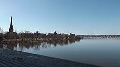 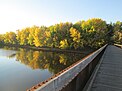 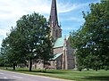 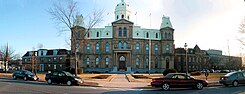 From top to bottom; left to right: Fredericton skyline, Pedestrian bridge of the Nashwaak River, Christ Church Cathedral, New Brunswick Legislative Building | |
 Flag  Coat of arms Logo | |
| Nicknames: Freddy, Freddy Beach | |
| Motto(s): "Fredericopolis, silvae filia nobilis" (Latin) "Fredericton, noble daughter of the forest" | |
 Interactive map outlining Fredericton | |
 Fredericton Location within New Brunswick | |
| Coordinates: 45°57′49″N 66°38′35″W / 45.96361°N 66.64306°WCoordinates: 45°57′49″N 66°38′35″W / 45.96361°N 66.64306°W | |
| Country | Canada |
| Province | New Brunswick |
| County(s) | York, Sunbury |
| Metropolitan area | Greater Fredericton |
| Erected | 1786 |
| Incorporated | 1848 |
| Named for | Prince Frederick, Duke of York and Albany |
| Government | |
| • Type | Fredericton City Council |
| • Mayor | [2] |
| • MPs | Jenica Atwin (Lib.) Richard Bragdon (Con.) |
| • MLAs | Jill Green (PC) David Coon (Green) Kris Austin (PA) Dominic Cardy (PC) Ryan Cullins (PC) |
| Area | |
| • City | 132.57 km2 (51.19 sq mi) |
| • Metro | 5,745.41 km2 (2,218.32 sq mi) |
| Elevation | 20−100 m (66−328 ft) |
| Population (2016)[3] | |
| • City | 58,220 |
| • Density | 439.2/km2 (1,138/sq mi) |
| • Metro | 101,760 |
| • Metro density | 17.7/km2 (46/sq mi) |
| Demonym(s) | Frederictonian |
| Time zone | UTC−04:00 (AST) |
| • Summer (DST) | UTC−03:00 (ADT) |
| Postal code(s) | E3A, E3B, E3C, E3E, E3G |
| Area code(s) | 506 |
| NTS Map | 21G15 Fredericton |
| GNBC Code | DAFMJ |
| Website | www.fredericton.ca |


Fredericton (/ˈfrɛ.drɪk.tən/;[5] French pronunciation: [fʁɛdeʁiktœn]) is the capital city of the Canadian province of New Brunswick. The city is situated in the west-central portion of the province along the Saint John River, which flows west to east as it bisects the city. The river is the dominant natural feature of the area. One of the main urban centres in New Brunswick, the city had a population of 58,220 in the 2016 Canadian Census.[3] It is the third-largest city in the province after Moncton and Saint John.
An important cultural, artistic, and educational centre for the province, Fredericton is home to two universities, the New Brunswick College of Craft and Design, and cultural institutions such as the Beaverbrook Art Gallery, the Fredericton Region Museum, and The Playhouse, a performing arts venue. The city hosts the annual Harvest Jazz & Blues Festival, attracting regional and international jazz, blues, rock, and world artists. Fredericton is also an important and vibrant centre point for the region's top visual artists; many of New Brunswick's notable artists live and work there today. Fredericton has also been home to some great historical Canadian painters as well, including Goodridge Roberts, and Molly and Bruno Bobak.
As a provincial capital, its economy is tied to the public sector; however, the city also contains a growing IT and commercial sector. The city has the highest percentage of residents with post-secondary education in the province and the highest per capita income of any city in New Brunswick.
History[]
There is archaeological evidence of a camp in the area 12,000 years ago,[6] and Maliseets farmed several kilometres upriver.[7]
Colonists from the Kingdom of France in the late 1600s built Fort Nashwaak on the north side of the Saint John River, as the capital of Acadia. It withstood a British attack in 1696, but the capital was later moved to Port Royale.[8] In 1713 Acadians escaping the British takeover of Nova Scotia settled the site, naming it Pointe Ste-Anne. It was destroyed in 1758 when the population of about 83 were exiled during the expulsion of the Acadians.
It was in 1783, when United Empire Loyalists arrived from New England, that the history of modern Fredericton began. The following year New Brunswick was partitioned from Nova Scotia and became its own colony. Pointe-Ste-Anne was renamed "Fredericstown", after Frederick, second son of King George III. It became the capital of the new colony, being considered to have a better defensive position than larger Saint John.[8]
The streets were laid out in the typical grid pattern of the time, with the names reflecting loyalist tendencies: Charlotte, Brunswick, George, King, and Queen.
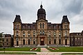
In 1785 it became the shire town of York County. In 1790 the New Brunswick Legislative Building was constructed. As a centre of government, it attracted educational institutions, with King's College (now the University of New Brunswick) being the first English-language university in Canada, and religious institutions, with Christ Church Cathedral being built as the seat of the Anglican Diocese of Fredericton in 1853.[9]
It was a British garrison town from 1784 to 1869, and the military compound is preserved as a National Historic Site of Canada.[10]
With the New Brunswick Equal Opportunity program in the 1960s, county councils were abolished, and government services were centralized provincially in Fredericton, increasing jobs and population.
Geography[]
The Saint John River runs through Fredericton, with most of the city's post-war suburban development occurring on the gently sloping hills on either side of the river (although the downtown core is flat and lies low to the river).
At an altitude of about 17 m (56 ft) above sea level, Fredericton is nestled in the Pennsylvanian Basin. It differs markedly from the geologically older parts of the province. There are prominently two distinct areas in the region that are divided around the area of Wilsey Road, in the east end of the city. In the west side, the bedrock underneath the earth is topographically dominant, whereas the other is controlled by Pleistocene and recent deposits leading to the rivers (resulting in the area being shallow and wide). Fredericton and its surroundings are rich in water resources, which, coupled with highly arable soil, make the Fredericton region ideal for agriculture. The Saint John River and one of its major tributaries, the Nashwaak River, come together in Fredericton. The uninhabited parts of the city are heavily forested.
Climate[]
| Fredericton | ||||||||||||||||||||||||||||||||||||||||||||||||||||||||||||
|---|---|---|---|---|---|---|---|---|---|---|---|---|---|---|---|---|---|---|---|---|---|---|---|---|---|---|---|---|---|---|---|---|---|---|---|---|---|---|---|---|---|---|---|---|---|---|---|---|---|---|---|---|---|---|---|---|---|---|---|---|
| Climate chart (explanation) | ||||||||||||||||||||||||||||||||||||||||||||||||||||||||||||
| ||||||||||||||||||||||||||||||||||||||||||||||||||||||||||||
| ||||||||||||||||||||||||||||||||||||||||||||||||||||||||||||
Fredericton has a humid continental climate (Dfb) with short, warm summers and long, cold winters. On average, Fredericton receives approximately 1,100 mm (43 in) of precipitation per year.
| Climate data for Fredericton CDA, 1981–2010 normals, extremes 1871–present[b] | |||||||||||||
|---|---|---|---|---|---|---|---|---|---|---|---|---|---|
| Month | Jan | Feb | Mar | Apr | May | Jun | Jul | Aug | Sep | Oct | Nov | Dec | Year |
| Record high °C (°F) | 15.0 (59.0) |
19.0 (66.2) |
26.5 (79.7) |
30.5 (86.9) |
35.5 (95.9) |
35.6 (96.1) |
36.1 (97.0) |
38.9 (102.0) |
33.7 (92.7) |
28.9 (84.0) |
21.7 (71.1) |
16.1 (61.0) |
38.9 (102.0) |
| Average high °C (°F) | −4.4 (24.1) |
−2.1 (28.2) |
2.8 (37.0) |
9.9 (49.8) |
17.6 (63.7) |
22.7 (72.9) |
25.4 (77.7) |
24.5 (76.1) |
19.6 (67.3) |
12.8 (55.0) |
5.5 (41.9) |
−1.0 (30.2) |
11.1 (52.0) |
| Daily mean °C (°F) | −9.4 (15.1) |
−7.5 (18.5) |
−2.2 (28.0) |
4.8 (40.6) |
11.3 (52.3) |
16.4 (61.5) |
19.4 (66.9) |
18.6 (65.5) |
14.0 (57.2) |
7.8 (46.0) |
1.8 (35.2) |
−5.3 (22.5) |
5.8 (42.4) |
| Average low °C (°F) | −14.4 (6.1) |
−12.8 (9.0) |
−7.2 (19.0) |
−0.4 (31.3) |
5.1 (41.2) |
10.1 (50.2) |
13.3 (55.9) |
12.6 (54.7) |
8.3 (46.9) |
2.8 (37.0) |
−2.0 (28.4) |
−9.5 (14.9) |
0.5 (32.9) |
| Record low °C (°F) | −38.9 (−38.0) |
−38.3 (−36.9) |
−32.8 (−27.0) |
−20.0 (−4.0) |
−6.7 (19.9) |
−2.2 (28.0) |
1.7 (35.1) |
1.7 (35.1) |
−4.4 (24.1) |
−11.1 (12.0) |
−26.7 (−16.1) |
−35.6 (−32.1) |
−38.9 (−38.0) |
| Average precipitation mm (inches) | 101.9 (4.01) |
70.1 (2.76) |
90.1 (3.55) |
81.6 (3.21) |
103.8 (4.09) |
86.3 (3.40) |
89.0 (3.50) |
85.9 (3.38) |
94.7 (3.73) |
89.7 (3.53) |
109.9 (4.33) |
91.8 (3.61) |
1,094.7 (43.10) |
| Average rainfall mm (inches) | 42.4 (1.67) |
31.7 (1.25) |
45.2 (1.78) |
68.1 (2.68) |
103.1 (4.06) |
86.3 (3.40) |
89.0 (3.50) |
85.9 (3.38) |
94.7 (3.73) |
89.3 (3.52) |
96.3 (3.79) |
54.0 (2.13) |
885.9 (34.88) |
| Average snowfall cm (inches) | 63.6 (25.0) |
39.1 (15.4) |
42.4 (16.7) |
13.5 (5.3) |
0.6 (0.2) |
0.0 (0.0) |
0.0 (0.0) |
0.0 (0.0) |
0.0 (0.0) |
0.4 (0.2) |
13.9 (5.5) |
41.4 (16.3) |
214.8 (84.6) |
| Average precipitation days (≥ 0.2 mm) | 12.6 | 10.2 | 12.4 | 12.6 | 14.9 | 13.6 | 14.5 | 12.7 | 13.7 | 13.5 | 13.8 | 12.5 | 156.7 |
| Average rainy days (≥ 0.2 mm) | 4.5 | 4.2 | 7.1 | 10.8 | 14.8 | 13.6 | 14.5 | 12.7 | 13.7 | 13.5 | 11.7 | 6.0 | 126.9 |
| Average snowy days (≥ 0.2 cm) | 9.4 | 7.2 | 7.0 | 2.4 | 0.3 | 0.0 | 0.0 | 0.0 | 0.0 | 0.11 | 3.2 | 7.5 | 37.0 |
| Mean monthly sunshine hours | 119.5 | 130.8 | 148.9 | 162.2 | 206.9 | 224.3 | 239.7 | 226.2 | 172.4 | 142.5 | 95.8 | 102.2 | 1,971.2 |
| Percent possible sunshine | 42.4 | 44.8 | 40.4 | 40.0 | 44.7 | 47.7 | 50.4 | 51.6 | 45.7 | 41.9 | 33.6 | 37.8 | 43.4 |
| Source: Environment Canada[12][13][14][15] | |||||||||||||
| Climate data for Fredericton Airport, 1981–2010 normals, extremes 1951–present | |||||||||||||
|---|---|---|---|---|---|---|---|---|---|---|---|---|---|
| Month | Jan | Feb | Mar | Apr | May | Jun | Jul | Aug | Sep | Oct | Nov | Dec | Year |
| Record high humidex | 17.1 | 17.3 | 28.0 | 33.3 | 38.1 | 43.5 | 44.5 | 43.3 | 39.6 | 32.0 | 25.0 | 19.5 | 44.5 |
| Record high °C (°F) | 14.6 (58.3) |
18.6 (65.5) |
27.2 (81.0) |
30.3 (86.5) |
35.2 (95.4) |
35.3 (95.5) |
36.7 (98.1) |
37.2 (99.0) |
34.1 (93.4) |
27.8 (82.0) |
21.1 (70.0) |
15.9 (60.6) |
37.2 (99.0) |
| Average high °C (°F) | −3.8 (25.2) |
−2.0 (28.4) |
3.0 (37.4) |
10.0 (50.0) |
17.6 (63.7) |
22.7 (72.9) |
25.5 (77.9) |
24.8 (76.6) |
20.0 (68.0) |
13.2 (55.8) |
6.0 (42.8) |
−0.7 (30.7) |
11.4 (52.5) |
| Daily mean °C (°F) | −9.4 (15.1) |
−7.9 (17.8) |
−2.4 (27.7) |
4.5 (40.1) |
11.1 (52.0) |
16.2 (61.2) |
19.3 (66.7) |
18.4 (65.1) |
13.6 (56.5) |
7.5 (45.5) |
1.5 (34.7) |
−5.7 (21.7) |
5.6 (42.1) |
| Average low °C (°F) | −15.0 (5.0) |
−13.7 (7.3) |
−7.8 (18.0) |
−1.0 (30.2) |
4.6 (40.3) |
9.7 (49.5) |
13.0 (55.4) |
12.1 (53.8) |
7.1 (44.8) |
1.6 (34.9) |
−3.0 (26.6) |
−10.7 (12.7) |
−0.2 (31.6) |
| Record low °C (°F) | −35.6 (−32.1) |
−37.2 (−35.0) |
−28.9 (−20.0) |
−15.1 (4.8) |
−6.7 (19.9) |
−0.6 (30.9) |
1.7 (35.1) |
1.3 (34.3) |
−3.9 (25.0) |
−8.9 (16.0) |
−20.2 (−4.4) |
−33.8 (−28.8) |
−37.2 (−35.0) |
| Record low wind chill | −45.1 | −46.4 | −38.0 | −26.1 | −12.5 | −4.3 | 0.0 | 0.0 | −6.6 | −13.1 | −26.5 | −42.2 | −46.4 |
| Average precipitation mm (inches) | 95.3 (3.75) |
73.1 (2.88) |
93.2 (3.67) |
85.9 (3.38) |
96.2 (3.79) |
82.4 (3.24) |
88.3 (3.48) |
85.6 (3.37) |
87.5 (3.44) |
89.1 (3.51) |
106.3 (4.19) |
94.9 (3.74) |
1,077.7 (42.43) |
| Average rainfall mm (inches) | 38.0 (1.50) |
31.4 (1.24) |
46.7 (1.84) |
68.3 (2.69) |
94.5 (3.72) |
82.4 (3.24) |
88.3 (3.48) |
85.6 (3.37) |
87.5 (3.44) |
88.2 (3.47) |
92.9 (3.66) |
55.3 (2.18) |
859.1 (33.82) |
| Average snowfall cm (inches) | 69.9 (27.5) |
47.5 (18.7) |
49.4 (19.4) |
18.6 (7.3) |
1.4 (0.6) |
0.0 (0.0) |
0.0 (0.0) |
0.0 (0.0) |
0.0 (0.0) |
0.8 (0.3) |
14.3 (5.6) |
50.5 (19.9) |
252.3 (99.3) |
| Average precipitation days (≥ 0.2 mm) | 14.2 | 11.3 | 13.0 | 13.2 | 13.9 | 12.2 | 12.3 | 10.6 | 10.3 | 11.4 | 13.2 | 13.4 | 148.9 |
| Average rainy days (≥ 0.2 mm) | 5.1 | 4.3 | 7.3 | 10.8 | 13.8 | 12.2 | 12.3 | 10.6 | 10.3 | 11.3 | 11.1 | 6.3 | 115.4 |
| Average snowy days (≥ 0.2 cm) | 11.7 | 9.1 | 8.5 | 4.7 | 0.38 | 0.0 | 0.0 | 0.0 | 0.0 | 0.42 | 4.2 | 10.0 | 48.9 |
| Average relative humidity (%) | 75.1 | 74.9 | 77.1 | 80.6 | 83.6 | 86.4 | 89.5 | 90.4 | 91.1 | 87.6 | 83.8 | 80.0 | 83.3 |
| Source: Environment Canada[11][16][17] | |||||||||||||
Demographics[]
| Year | Pop. | ±% |
|---|---|---|
| 1861 | 6,000 | — |
| 1901 | 7,117 | +18.6% |
| 1941 | 10,062* | — |
| 1976 | 45,248* | — |
| 2001 | 48,560 | — |
| 2016 | 58,220 | +19.9% |
| *Boundary changes for 1941 and 1973 | ||
The population of the city of Fredericton is 58,220 (2016 Canada Census) and 101,760 for Greater Fredericton.[3][4] Along with Moncton and Halifax, Fredericton is one of three Maritime cities to register a recent population increase.
Fredericton's population are predominantly European Canadians. Visible minorities make up 10 per cent, and include, in descending order of population, Indigenous peoples (many the St. Mary's First Nation Indian reserve), Chinese Canadians, Black Canadians, South Asian Canadians, Arab Canadians, and refugees from the Syrian Civil War.[18][19]
English is spoken as a mother tongue by 83.7% of residents. Other mother tongues are French (7.8%), Chinese languages (2.1%), Arabic (1.7%), and Russian (0.6%).[20]
Those who declare a religion are predominantly Protestant. Fredericton has a synagogue,[21] a mosque,[22] a Hindu temple,[23] a Unitarian fellowship,[24] and a Shambhala Buddhist meditation centre.[25]
| Religion[26] | 2011 (%) | 2011 (Total) |
|---|---|---|
| No religion | 26.2% | 14,460 |
| Catholic | 24.9% | 13,740 |
| Baptist | 11.4% | 6,290 |
| United Church | 10.9% | 5,995 |
| Anglican | 9.4% | 5,160 |
| Pentecostal | 2.5% | 1,390 |
Economy[]
The Government of New Brunswick and the universities are the primary employers. The policies of centralizing provincial government functions during the 1960s led to an expansion of the population.
The 1960s also saw an expansion of the University of New Brunswick due to increased post-war university enrolment, as well as the construction of Saint Thomas University. The Law School, now the University of New Brunswick Faculty of Law moved from Saint John to the Fredericton area.
The city has been investing actively in IT infrastructure. The City of Fredericton won the "Judges Innovation Award" at the 2004 Canadian Information Productivity Awards due to their "Fred-eZone" free municipality wide Wi-Fi initiative. This and other innovations by the city's utelco, e-Novations, led Intel to do a case study on their successes. Fred-eZone spans much of the city's downtown and parts of surrounding residential areas, as well as peripheral commercial areas such as Fredericton's Regent Mall. In 2008 and 2009 the Intelligent Community Forum selected Fredericton as a Top 7 Intelligent Community, based partly on the city's work in the IT sector.[27]
Arts and culture[]
The Playhouse is the main venue for Theatre New Brunswick, the province's largest professional theatre company.
Festivals include the Harvest Jazz & Blues Festival, the New Brunswick Summer Music Festival, the Silver Wave Film Festival and Symphony New Brunswick.
Fredericton has a long literary tradition, having been home to Jonathan Odell, Charles G. D. Roberts, Bliss Carman, and Francis Sherman.[28] Writers living in Fredericton include Raymond Fraser, Herb Curtis, David Adams Richards, Mark Anthony Jarman, and Gerard Beirne.
Architecture[]
Styles range from Victorian to modern. There are 12 National Historic Sites of Canada.[29]
Museums and historic buildings[]
- Beaverbrook Art Gallery
- New Brunswick Legislative Building
- Old Government House
- Fredericton Region Museum
- Christ Church Cathedral
- New Brunswick Sports Hall of Fame
- Science East
- Sir Howard Douglas Hall (Old Arts Building)
- William Brydone Jack Observatory
- St. Anne's Chapel
- Fort Nashwaak
- Fredericton City Hall
- Marysville Cotton Mill
- Centennial Building
Sports[]
There are no professional sports teams in Fredericton, although both universities have extensive athletic programs. The UNB Reds play in the Atlantic University Sport conference of U Sports[30] and St. Thomas Tommies play in the Atlantic Collegiate Athletic Association conference of the Canadian Collegiate Athletic Association for most sports, although their women's hockey team, cross-country teams, and track & field teams play in the Atlantic University Sports conference of U Sports.[31]
Fredericton's high schools compete in a variety of sports in the New Brunswick Interscholastic Athletic Association.
The Junior A hockey team is the Fredericton Red Wings.[32] The former Fredericton Express and Fredericton Canadiens were American Hockey League teams.
Each summer the Fredericton Loyalists host the New Brunswick Timber team which competes in the Rugby Canada Super League.
Parks and recreation[]
- Carleton Park, part of the Northside Riverfront Trail, includes a boat launching area. The park, which was once the site of Alexander "Boss" Gibson's rail yard.
- The Green, along the north and south banks of the Saint John River, a walking and biking trail.
- Killarney Lake Park, a lakeside park with a beach and picnic spots as well as an extensive network of nature trails.
- Odell Park, features preserved forested areas, trails, spaces for picnics and gatherings, and the Fredericton Botanic Garden .
- Officers' Square is a venue for outdoor concerts and has an outdoor skating rink in the winter.
- Queen Square Park, in the heart of Downtown Fredericton.
- Reading Park (/ˈrɛdɪŋ/ (
 listen) RED-ing) is a 33-acre (130,000 m2) passive use park incorporating an open meadow, and a 1.1 km (0.68 mi) walking trail through an old-growth forest. The park's old-growth forest is one of the city's last remaining habitats for the pileated woodpecker.
 - Wilmot Park - a recreational park downtown.
Trail system[]
Fredericton has a network of 25 trails totalling more than 85 km (53 mi) on both sides of the Saint John and Nashwaak Rivers. Many of the city trails are rail trails that follow old railway lines. These include the Fredericton Railway Bridge that spans 0.6 km (0.37 mi) across the Saint John River. The rail trail system in Fredericton is part of the Sentier NB Trail system and some of these trails are also part of the larger Trans-Canada Trail network.
Government[]

Fredericton has a non-partisan and Mayor–council government. The mayor and council serve four-year terms with elections in May. The city is divided into 12 wards, (six on each side of the river, one councillor per ward.
The city includes the provincial ridings of Fredericton North, Fredericton-Grand Lake, Fredericton West-Hanwell, Oromocto-Lincoln-Fredericton, New Maryland-Sunbury and Fredericton South, which in 2014 elected the first-ever MLA for the Green Party of New Brunswick, party leader David Coon.
Federally, the city forms most of the riding of Fredericton.
Education and research[]
The Anglophone West School District and the District Scolaire Francophone Sud (District 1) run schools including Fredericton High School, , and the École Sainte-Anne. Leo Hayes High School is a public–private partnership
There are two universities, the UNB, and St. Thomas, the province's only Catholic university.
Colleges include the New Brunswick College of Craft and Design, the New Brunswick Community College, and the Maritime College of Forest Technology.
For-profit universities include University of Fredericton and Yorkville University.
The Hugh John Flemming Forestry Centre researches in forestry management. Fredericton's Provincial Research Organization specializes in aquaculture, mining, manufacturing, energy and the environment.[33]
Transportation[]
Air service is provided out of the Fredericton International Airport.
Fredericton Transit provides bus service, though not on Sundays.
Fredericton started installing bicycle lanes in July 2008.[34]
Passenger rail service ended in the 1960s,[35] and freight in 1996. All railway tracks have been abandoned and removed.
Fredericton is served by the Maritime Bus fleet which provides connections to points throughout Eastern Canada.[36]
The Trans-Canada Highway passes along the southern municipal boundary. Routes 7 and 8 (the latter being a former alignment of the Trans-Canada) also pass through the city. Two highway bridges, the Westmorland Street Bridge and the Princess Margaret Bridge, cross the Saint John River. Those bridges feed into controlled-access roads (Routes 8 and 105 serving the city's north side).
Gallery[]

The Nashwaak River Trail
The Beaverbrook Art Gallery

Celebration of Acadian culture in Fredericton
Queen Square Park

Marysville Place houses a number of offices for the provincial government.

Downtown Fredericton

Fredericton Transit bus with bike rack


Notes[]
References[]
- ^ "RÈGLEMENT DU NOUVEAU-BRUNSWICK 85-6 pris en vertu de la Loi sur les municipalités (D.C. 85-45)". Government of New Brunswick. Retrieved 17 August 2021.
- ^ "Fredericton councillor defeats incumbent mayor in one of several races across the province". atlantic.ctvnews.ca. 25 May 2021.
- ^ a b c d "Census Profile, 2016 Census Fredericton, City [Census subdivision], New Brunswick". Statistics Canada. Retrieved 28 July 2019.
- ^ a b c "Census Profile, 2016 Census Fredericton [Census agglomeration], New Brunswick". Statistics Canada. Retrieved 28 July 2019.
- ^ "Fredericton". Dictionary.com. Retrieved 21 December 2020.
- ^ CBC News: "Campsite dating back 12,000 years unearthed by Route 8", 23 June 2016
- ^ Hall, Jason (Summer–Autumn 2015). "Maliseet Cultivation and Climatic Resilience on the Wəlastəkw/St. John River During the Little Ice Age". Acadiensis. XLIV (2): 3–25. JSTOR 24877276.;
• Raymond, Wm. O. (1910). The River St. John: Its Physical Features, Legends and History, from 1604 to 1784. Saint John, New Brunswick: John A. Bowes. - ^ a b "A Brief History of Fredericton". Fredericton Heritage Trust. Retrieved 3 July 2020.
- ^ "Fredericton". The Canadian Encyclopedia. Retrieved 3 July 2020.
- ^ "Fredericton Military Compound National Historic Site of Canada". www.pc.gc.ca. Retrieved 3 July 2020.
- ^ a b "Fredericton A". Canadian Climate Normals 1981–2010. Environment Canada. Retrieved 12 May 2014.
- ^ "Fredericton CDA". Canadian Climate Normals 1981–2010. Environment Canada. Retrieved 12 May 2014.
- ^ "Fredericton UNB". Canadian Climate Data. Environment Canada. Retrieved 9 April 2016.
- ^ "Daily Data Report for September 2010". Canadian Climate Data. Environment Canada. Retrieved 26 June 2016.
- ^ "Daily Data Report for March 2012". Canadian Climate Data. Environment Canada. Retrieved 26 June 2016.
- ^ "Sep 2010". Canadian Climate Data. Environment Canada. Retrieved 26 June 2016.
- ^ "Mar 2012". Canadian Climate Data. Environment Canada. Retrieved 26 June 2016.
- ^ Government of Canada, Statistics Canada (8 February 2017). "Census Profile, 2016 Census - Fredericton, City [Census subdivision], New Brunswick and York, County [Census division], New Brunswick". www12.statcan.gc.ca. Retrieved 17 July 2019.
- ^ "Fredericton welcomed more Syrians per capita than other Canadian cities: multicultural association".
- ^ Government of Canada, Statistics Canada (31 August 2017). "Data tables, 2016 Census: Mother Tongue (263), Single and Multiple Mother Tongue Responses (3), Age (7) and Sex (3) for the Population Excluding Institutional Residents of Canada, Provinces and Territories, Census Divisions and Census Subdivisions, 2016 Census - 100% Data". Retrieved 1 December 2020.
- ^ "Sgoolai Israel Synagogue". Retrieved 1 December 2020.
- ^ "Fredericton Islamic Association". Retrieved 1 December 2020.
- ^ Orientation guide for newcomers to New Brunswick (PDF). p. 91. Retrieved 1 December 2020.
- ^ "Unitarian Fellowship of Fredericton". Retrieved 1 December 2020.
- ^ "Fredericton Shambhala Center". Retrieved 25 March 2014.
- ^ Government of Canada, Statistics Canada (8 May 2013). "2011 National Household Survey Profile - Census subdivision". www12.statcan.gc.ca. Retrieved 17 July 2019.
- ^ Intelligent Community Forum (2014). "Top 7 By Year". Archived from the original on 9 February 2014. Retrieved 25 March 2014.
- ^ "Fredericton New Brunswick, Canada". Encyclopedia Britannica. Retrieved 3 July 2020.
- ^ "Fredericton". Directory of Designations of National Historic Significance of Canada. Parks Canada. Retrieved 3 March 2012.[permanent dead link]
- ^ "UNB Reds Athletics".
- ^ "STU Tommies Athletics".
- ^ Gill, Jordan (16 April 2019). "Junior A hockey returns to Fredericton - and St. Stephen mourns loss of team". CBC. Retrieved 15 May 2019.
- ^ "RPC - Science & Engineering". www.rpc.ca. Retrieved 3 July 2020.
- ^ "Bike Lanes and Bike Routes in Fredericton". City of Fredericton. Retrieved 6 April 2013.
- ^ Johnson, Robert (27 January 2013). "What Happened to the Fredericton Train Station". The New Brunswick Beacon. Retrieved 6 April 2013.
- ^ "Maritime Bus organising fleet for Dec 1 start". The Guardian (Charlottetown). 21 November 2012. Archived from the original on 28 June 2013. Retrieved 6 April 2013.
Further reading[]
- Dallison, Robert L. "A Tour of Boss Gibson's Marysville: A Nineteenth Century Mill Town." Fredericton Heritage Trust, 1991.
- Hachey, Philip Osmond "The geology and ground water of the Fredericton district." UNB Thesis, 1955.
- McIntyre, Glen, Bruce Oliver and Bob Watson, "A Valuable and Important Place - Fredericton's Loyalist Origins 1783." A Fredericton Historical Research Project, 1983.
See also[]
- People from Fredericton
- Gangnam-gu, South Korea: partner city
- Imperial Order Daughters of the Empire (IODE), the first chapter of which was formed in Fredericton on 15 January 1900
- List of cities in Canada
- Fredericton Public Library
- Nashwaaksis
- Media in Fredericton
- The Playhouse
- Dr. Everett Chalmers Regional Hospital
- Douglas
- Hanwell
- Marysville
- Nashwaaksis
External links[]
| Wikimedia Commons has media related to Fredericton, New Brunswick. |
| Look up fredericton in Wiktionary, the free dictionary. |
| Wikivoyage has a travel guide for Fredericton. |
Places adjacent to Fredericton | ||||||||||||||||
|---|---|---|---|---|---|---|---|---|---|---|---|---|---|---|---|---|
| ||||||||||||||||
Subdivisions of New Brunswick | |
|---|---|
| Subdivisions |
|
| Cities |
|
| |
Authority control | |
|---|---|
| General | |
| National libraries | |
| Other |
|
- Fredericton
- Cities in New Brunswick
- Former colonial capitals in Canada
- Greater Fredericton
- Populated places established in 1785
- New Brunswick populated places on the Saint John River (Bay of Fundy)