Frelighsburg, Quebec
Frelighsburg | |
|---|---|
Municipality | |
 The Freligh Mill on Pike River | |
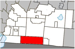 Location within Brome-Missisquoi RCM. | |
 Frelighsburg Location in southern Quebec. | |
| Coordinates: 45°03′N 72°50′W / 45.050°N 72.833°WCoordinates: 45°03′N 72°50′W / 45.050°N 72.833°W[1] | |
| Country | Canada |
| Province | Quebec |
| Region | Montérégie |
| RCM | Brome-Missisquoi |
| Constituted | September 28, 1985 |
| Government | |
| • Mayor | Jean Lévesque |
| • Federal riding | Brome—Missisquoi |
| • Prov. riding | Brome-Missisquoi |
| Area | |
| • Total | 124.60 km2 (48.11 sq mi) |
| • Land | 123.72 km2 (47.77 sq mi) |
| Population (2011)[3] | |
| • Total | 1,094 |
| • Density | 8.8/km2 (23/sq mi) |
| • Pop 2006-2011 | |
| • Dwellings | 566 |
| Time zone | UTC−5 (EST) |
| • Summer (DST) | UTC−4 (EDT) |
| Postal code(s) | J0J 1C0 |
| Area code(s) | 450 and 579 |
| Highways | |

Frelighsburg is a municipality in the Brome-Missisquoi Regional County Municipality, which is part of the administrative region of the Montérégie of Quebec, (but the Eastern Townships touristic region) Canada. Its population, as of the Canada 2011 Census, was 1,094. The area was historically considered to be part of the Eastern Townships.
Frelighsburg is situated at the foot of Le Pinnacle, which is part of the of the Appalachian Mountains.
History[]
Frelighsburg is on land that was originally inhabited by the Abenaki. It was established as a colony in the late 1790s by American Loyalists, including pioneer Abram Freligh, a physician of German origin who lived in Clinton, New York. The sawmill built by his son in 1839, and several other buildings from the 19th century are considered historical monuments. Prior to being named Frelighsburgh it was named Conroy's Mills, named after another mill owner, and Slab City because of the great quantities of sawdust and slabs (slang for bark) that were there.[1]
Geography[]
Frelighsburg is less than 4 kilometres (2.5 mi) from the Canada–US border with Vermont, nestled in a valley of orchards crossed by the Pike River and at the foot of Mount Pinnacle.
Demographics[]
|
|
Infrastructure[]
Frelighsburg is crossed by the Route 237. Route 213 starts in Frelighsburgh.
Gallery[]
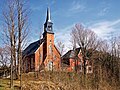
Saint-François d'Assise Church

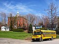
Frelighsburg Town Hall
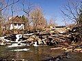
Hunter Falls
Ecole Saint-François d'Assise
Orchard - Maison d'époque.


See also[]
- Municipality of Frelighsburg - Official Site
- List of municipalities in Quebec
- TAC of Frelighsburg[permanent dead link]
References[]
- ^ Jump up to: a b http://www.toponymie.gouv.qc.ca/ct/ToposWeb/fiche.aspx?no_seq=148987 Frelighsburg - Commission de toponymie du Québec
- ^ Jump up to: a b Geographic code 46010 in the official Répertoire des municipalités (in French)
- ^ Jump up to: a b 2011 Statistics Canada Census Profile: Frelighsburg, Quebec
- ^ Statistics Canada: 1996, 2001, 2006, 2011 census
- ^ 2006 Statistics Canada Community Profile: Frelighsburg, Quebec
External links[]
 Media related to Frelighsburg at Wikimedia Commons
| show Adjacent Municipal Subdivisions |
|---|
| hide | |
|---|---|
| Cities & Towns |
|
| Municipalities |
|
| Townships | |
| Villages | |
| |
| show Authority control |
|---|
- Municipalities in Quebec
- Incorporated places in Brome-Missisquoi Regional County Municipality
- Designated places in Quebec