Gaythorne, Queensland
| Gaythorne Brisbane, Queensland | |||||||||||||||
|---|---|---|---|---|---|---|---|---|---|---|---|---|---|---|---|
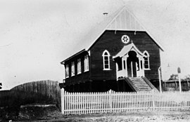 Enoggera Presbyterian Church, at Pickering Street, Gaythorne, 1915 | |||||||||||||||
 Gaythorne | |||||||||||||||
| Coordinates | 27°25′04″S 152°59′00″E / 27.4177°S 152.9833°ECoordinates: 27°25′04″S 152°59′00″E / 27.4177°S 152.9833°E | ||||||||||||||
| Population | 3,024 (2016 census)[1] | ||||||||||||||
| • Density | 2,750/km2 (7,100/sq mi) | ||||||||||||||
| Postcode(s) | 4051 | ||||||||||||||
| Area | 1.1 km2 (0.4 sq mi) | ||||||||||||||
| Location | 9 km (6 mi) from Brisbane | ||||||||||||||
| LGA(s) | City of Brisbane (Enoggera Ward)[2] | ||||||||||||||
| State electorate(s) | |||||||||||||||
| Federal Division(s) | Ryan | ||||||||||||||
| |||||||||||||||

Gaythorne is a suburb in the City of Brisbane, Queensland, Australia.[3] In the 2016 census, Gaythorne had a population of 3,023 people.[1]
Geography[]
Gaythorne is located seven kilometres north-west of the Brisbane central business district. It is bounded to the north by Kedron Brook.[4] Gaythorne is situated on the slopes of Enoggera Hill. It shares some streets with the neighbouring suburb of Mitchelton. In the late 1990s it was split from Enoggera, a much larger suburb and they continue to share a postcode. It is a leafy, residential suburb with the dominant architectural style being "Queenslander" architecture. It adjoins the Enoggera Barracks and many of its streets are named after World War I sites.
Public transport facilities include Gaythorne railway station on the Ferny Grove - City line.
History[]

The suburb takes its name from a property in the area owned by Howard Bliss.[3][5]
On Saturday 15 May 1915 there was a stump capping ceremony for a new Presbyterian church at Enoggera (as the area was then called).[6] The location was on the corner of Pickering Street and Station Avenue (27°25′07″S 152°59′09″E / 27.4185°S 152.9859°E). In 1926 the church was extended to create a Sunday school.[7] As part of the merger of many of the Methodist, Presbyterian and Congregational churches into the Uniting Church of Australia in 1977, the church became Gaythorne Uniting Church. However, falling congregation numbers led to a consolidation of Uniting churches in the area, leading to the closure of the former Presbyterian church. Since 2012, it has been used as an early education centre.[8]
In May 1919, subdivided allotments of Rangeview Estate Enoggera were auctioned by Cameron Bros.[9] This area was within the suburb of Enoggera. The map advertising the auction states that the Estate was within 5 minutes' walk away from the Rifle Range Railway Station, now known as Gaythorne Station.[10][11] In April 1921, the land unsold was re-offered through auctioneers Cameron Bros as "Gaythorne & Rangeview Estates" made up of 53 allotments.[12][13]
On Saturday 18 April 1924 auctioneers Isles, Love, & Co offered 170 residential lots in the Bellevue Park Estate in Enoggera Heights. It was described as fronting Samford Road and Bellevue Avenue at the junction with Pickering Street (27°24′57″S 152°59′01″E / 27.4158°S 152.9837°E).[14]
All Souls' Anglican church was dedicated on 26 March 1961 by Archbishop Halse and consecrated on 9 March 1975 by Archbishop Arnott. Its closure was approved circa 1986.[15] It was located at 10 Tel El Kebir Street on the corner of Heliopolis Parade (27°25′00″S 152°58′43″E / 27.4166°S 152.9787°E), which is now within the neighbouring suburb of Mitchelton.[16] As at 2020, the building is used as a child care centre.
In the 2011 census, Gaythorne recorded a population of 2,655 people.[citation needed]
In the 2016 census, Gaythorne had a population of 3023 people.[1]
Education[]
There are no schools in Gaythorne but primary and secondary schools are available in neighbouring suburbs Mitchelton and Enoggera.[4]
Amenities[]
The Queensland Family History Society operates a library at 58 Bellevue Avenue (27°24′55″S 152°58′58″E / 27.4153°S 152.9829°E).[17]
Demographics[]
In the 2011 census, Gaythorne recorded a population of 2,655 people, 51.6% female and 48.4% male.
The median age of the Gaythorne population was 31 years of age, 6 years below the Australian median.
80.2% of people living in Gaythorne were born in Australia, compared to the national average of 69.8%; the next most common countries of birth were England 2.4%, New Zealand 2.2%, India 1.5%, Nepal 0.6%, Philippines 0.5%.
88.2% of people spoke only English at home; the next most popular languages were 1% Cantonese, 0.8% Mandarin, 0.7% Spanish, 0.6% Punjabi, 0.6% Nepali.
References[]
- ^ Jump up to: a b c Australian Bureau of Statistics (27 June 2017). "Gaythorne (SSC)". 2016 Census QuickStats. Retrieved 20 October 2018.

- ^ "Enoggera Ward". Brisbane City Council. Brisbane City Council. Archived from the original on 5 March 2017. Retrieved 12 March 2017.
- ^ Jump up to: a b "Gaythorne – suburb in City of Brisbane (entry 44258)". Queensland Place Names. Queensland Government. Retrieved 23 April 2019.
- ^ Jump up to: a b "Queensland Globe". State of Queensland. Retrieved 22 April 2019.
- ^ "MR. H. S. BLISS". The Week. XCVIII (2, 535). Queensland, Australia. 25 July 1924. p. 10. Retrieved 23 April 2019 – via National Library of Australia.
- ^ "A NEW PRESBYTERIAN CHURCH". The Brisbane Courier (17, 888). Queensland, Australia. 17 May 1915. p. 9. Retrieved 11 August 2019 – via National Library of Australia.
- ^ Bartsch, Phil (28 February 2020). "Church deal just a bit of child's play". The Courier-Mail. p. 53.
- ^ "Site 71 - Enoggera Presbyterian Church, Pickering Street, Gaythorne, 1915". Mitchy Memories. Archived from the original on 10 August 2019. Retrieved 10 August 2019.
- ^ "SALE OF RANGEVIEW ESTATE". Daily Mail (5173). Queensland, Australia. 26 May 1919. p. 2. Retrieved 30 July 2019 – via National Library of Australia.
- ^ "Rangeview Estate". 1919. hdl:10462/deriv/252824. Cite journal requires
|journal=(help) - ^ "Railway Station Renamed". The Brisbane Courier (20, 437). Queensland, Australia. 24 July 1923. p. 9. Retrieved 30 July 2019 – via National Library of Australia.
- ^ "Advertising". Daily Standard (2584). Queensland, Australia. 13 April 1921. p. 6 (SECOND EDITION). Retrieved 25 March 2019 – via National Library of Australia.
- ^ "Gaythorne & Rangeview Estates". hdl:10462/deriv/410769. Cite journal requires
|journal=(help) - ^ "Advertising". The Brisbane Courier. Queensland, Australia. 18 April 1914. p. 9. Retrieved 28 February 2020 – via Trove.
- ^ "Closed Churches". Anglican Records and Archives Centre, Anglican Church of Southern Queensland. Archived from the original on 3 April 2019. Retrieved 27 February 2019.
- ^ Universal Business Directories (Aust.) Pty. Ltd (1990). UBD street directory. Brisbane. Universal Business Directories (Australia).
- ^ "Queensland Family History Society". Brisbane Heritage Living Network. Archived from the original on 1 July 2020. Retrieved 1 July 2020.
External links[]
| Wikimedia Commons has media related to Gaythorne, Queensland. |
- University of Queensland: Queensland Places: Gaythorne
- "Gaythorne". BRISbites. Brisbane City Council. Archived from the original on 19 July 2008.
- "Gaythorne". Our Brisbane. Brisbane City Council. Archived from the original on 22 February 2008.
- Suburbs of the City of Brisbane