Rocklea, Queensland
| Rocklea Brisbane, Queensland | |||||||||||||||
|---|---|---|---|---|---|---|---|---|---|---|---|---|---|---|---|
 The Brisbane Markets within the suburb | |||||||||||||||
 Rocklea | |||||||||||||||
| Coordinates | 27°33′09″S 153°00′10″E / 27.5524°S 153.0027°ECoordinates: 27°33′09″S 153°00′10″E / 27.5524°S 153.0027°E | ||||||||||||||
| Population | 1,595 (2016 census)[1] | ||||||||||||||
| • Density | 171.5/km2 (444.2/sq mi) | ||||||||||||||
| Postcode(s) | 4106 | ||||||||||||||
| Area | 9.3 km2 (3.6 sq mi) | ||||||||||||||
| Time zone | AEST (UTC+10:00) | ||||||||||||||
| Location | 11.1 km (7 mi) SSW of Brisbane GPO | ||||||||||||||
| LGA(s) | City of Brisbane (Moorooka Ward)[2] | ||||||||||||||
| State electorate(s) | |||||||||||||||
| Federal division(s) | Moreton | ||||||||||||||
| |||||||||||||||

Rocklea is a suburb in the City of Brisbane, Queensland, Australia.[3] In the 2016 census, Rocklea had a population of 1,595 people.[1]
Geography[]
Rocklea is located 9 kilometres south of the city. The west of the suburb is bordered by the Oxley Creek. The suburb's name is derived from the Rocky Waterholes in the area.
It is also at one end of the Ipswich Motorway; Ipswich Road continues north from the Ipswich Motorway, through Moorooka and into the Brisbane central business district.
The Beenleigh railway line passes through the suburb which is serviced by Rocklea railway station.
Rocklea is a mostly industrial suburb, being the home to many large firms from a range industries.[4]
History[]
The locality was originally called Rocky Waterholes Creek. It was renamed Rocklea after a town in Dorset, England, with the opening of the Beenleigh railway line in 1884 as it was felt the original name was too long.[3][5]
The suburb was once the centre of the Shire of Yeerongpilly, which was established in 1879 and disbanded in 1925 after the City of Brisbane was created.
In August 1884, E. Hooker and Son auctioned 29 allotments of the Rocklea Estate. The map shows area near Ipswich Road and the Rocklea railway station.[6][7]
In September 1884, Hooker, Sons and Elliott Auctioneers auctioned 214 allotments of the Rocklea Township estate. The allotments were on Hawtree, Brier, Piers, Holmes and Blackburn Streets.[8][9] Also in September 1884, John W. Todd auctioned 28 large blocks of the Mount Pleasant Estate. The map shows the area in Rocklea bordered by Ipswich Road and what is now Boundary Road, opposite what is now Archerfield Airport.[10][11]
In September 1884, 238 subdivided allotments of Rocky Waterholes Township Proper were auctioned by John Cameron.[12][13] The following year, in December 1885, 152 subdivided allotments of Rocky Waterholes Township Proper Estate were auctioned by John Cameron Auctioneer. A map advertising the estate shows it to be very close to Rocky Waterholes Creek.[14][15]
Rocklea State School opened on 29 September 1885.[4][16]
In January 1925, work commenced on the Sydney–Brisbane rail corridor.[17]
Rocklea Tramline Estate was advertised for auction on 11 September 1915 by Henry B Watson, auctioneer. 189 building sites were offered on Freney and Bale Streets, Rocklea. The map advertising the estate sale states that the estate was six minutes from Rocklea and Salisbury railway stations.[18][19]
Show Ground Estate Rocklea was offered for sale in the late 1920s by Queensland Development Company, consisting of 104 allotments. The estate map shows the Sydney-Brisbane rail corridor under construction (built 1925-1930). The Estate was adjacent to the Rocklea Showground and included Goburra, Corella, Boobook and Galah Streets. The southern border of the estate is labelled Fauna Parade, now Fauna Parade Park.[20]
In May 1928, W. J. Down and Co auctioned 55 allotments of the Abercrombie Estate. The map shows that the estate is in walking distance from the Rocklea railway station.[21][22]
In 1949, Commonwealth Engineering established a railway factory in Rocklea.[23]
The on a 53 hectares (130 acres) were officially opened on 31 August 1964 by the Premier of Queensland, Frank Nicklin.[4][24] The first markets in Brisbane were at Market Street and produce was delivered by boats on the Brisbane River. In 1864 the markets relocated to Roma Street Markets where they were very well-located to Roma Street railway station which opened in 1873 enabling produce to be sent by rail. The markets expanded over time into Turbot Street until the traffic congestion created by the markets forced the markets to move to the suburbs in the 1960s.[25][26]
On 31 July 2009, the last race was held at the Rocklea horse harness racing track.
At the 2011 census, Rocklea had a population of 1,255.[27]
In the 2016 census, Rocklea had a population of 1,595 people.[1]
Education[]
Rocklea State School is a government primary (Prep-6) school for boys and girls at 19 Elmes Road (27°32′48″S 153°00′42″E / 27.5466°S 153.0118°E).[28][29] In 2017, the school had an enrolment of 38 students with 7 teachers (4 full-time equivalent) and 8 non-teaching staff (4 full-time equivalent).[30]
There is no secondary school in Rocklea. The nearest secondary schools are Corinda State High School in Corinda to the north-west, Yeronga State High School in Yeronga to the north-east, and Glenala State High School in Inala to the south-west.[16]
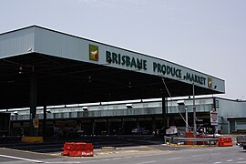
Fruit and vegetable market[]
The Brisbane Markets occupy a 100-hectare (250-acre) site on Sherwood Road (27°32′00″S 153°00′03″E / 27.5334°S 153.0007°E) where fresh fruit, vegetables, and flowers are sold to the wholesalers and retailers.[4]
Industry[]
The suburb is predominately zoned for industrial land uses. Many of the companies situated in Rocklea are part of the transport sector, with the proximity to Archerfield Airport being a drawcard. The Rocklea Works of English Electric built diesel-electric locomotives for several operators including the Queensland Railways 1600 class and successor classes.
DuluxGroup's main paint manufacturing facility is located in the suburb.[31]
Flooding[]
Rocklea is one of Brisbane's most flood affected suburbs. Severe damage was experienced in both the 1974 Brisbane flood and 2010–2011 Queensland floods. Flooding in Rocklea is particularly harmful to the coastal ecosystem because of the oil and other toxic chemicals which are washed downstream.[32] The effect of flooding on the Brisbane Markets was minor in 1974 but since then the site has grown five times and in 2011 35 buildings were inundated.[26]
After the 2011 flood, home and land values in the suburb decreased dramatically. The median house price decreased by 23.9%.[33]
Demographics[]
In the 2011 census, the population of Rocklea was 1,255, 45.3% female and 54.7% male. The median age of the Rocklea population was 36 years, one year below the Australian median. 60.5% of people living in Rocklea were born in Australia, which is somewhat less than the national average of 69.8%. The other top responses for country of birth were New Zealand 5.2%, England 2.5%, India 2.2%, China 1.8%, Russia 1.4%. 69.4% of people spoke only English at home; the next most popular languages were 2.9% Russian, 2.8% Vietnamese, 2.1% Mandarin, 1.8% Tamil, 1.7% Arabic. The most common religious affiliation was "no religion" (25%), followed by Catholic (22%) and Anglican (10%).[27]
References[]
- ^ a b c Australian Bureau of Statistics (27 June 2017). "Rocklea (SSC)". 2016 Census QuickStats. Retrieved 20 October 2018.

- ^ "Moorooka Ward". Brisbane City Council. Brisbane City Council. Retrieved 12 March 2017.
- ^ a b "Rocklea – suburb in City of Brisbane (entry 44217)". Queensland Place Names. Queensland Government. Retrieved 26 January 2020.
- ^ a b c d "Rocklea". ourbrisbane.com via the Wayback Machine. Brisbane City Council. 10 April 2010. Archived from the original on 19 June 2008. Retrieved 20 March 2011.
- ^ "NOMENCLATURE OF QUEENSLAND— 252". The Courier-Mail. 21 July 1936. p. 12.
- ^ "Rocklea Estate : 29 allotments". hdl:10462/deriv/459785. Cite journal requires
|journal=(help) - ^ "Classified Advertising". The Brisbane Courier. XXXIX (8, 311). Queensland, Australia. 29 August 1884. p. 8. Retrieved 27 August 2019 – via National Library of Australia.
- ^ "Rocklea township". hdl:10462/deriv/18411. Cite journal requires
|journal=(help) - ^ "Classified Advertising". The Brisbane Courier. XXXIX (8, 323). Queensland, Australia. 12 September 1884. p. 6. Retrieved 27 August 2019 – via National Library of Australia.
- ^ "Mount Pleasant Estate". hdl:10462/deriv/456243. Cite journal requires
|journal=(help) - ^ "Classified Advertising". The Brisbane Courier. XXXIX (8, 327). Queensland, Australia. 17 September 1884. p. 8. Retrieved 27 August 2019 – via National Library of Australia.
- ^ "Rocky Waterholes Township Proper". hdl:10462/deriv/456245. Cite journal requires
|journal=(help) - ^ "Classified Advertising". The Brisbane Courier. XXXIX (8, 323). Queensland, Australia. 12 September 1884. p. 7. Retrieved 27 August 2019 – via National Library of Australia.
- ^ "Rocky Waterholes Township Proper". hdl:10462/deriv/264343. Cite journal requires
|journal=(help) - ^ "Classified Advertising". The Brisbane Courier. XL (8, 702). Queensland, Australia. 4 December 1885. p. 7. Retrieved 27 August 2019 – via National Library of Australia.
- ^ a b "Queensland Globe". State of Queensland. Retrieved 4 March 2020.
- ^ Buchanan, Robyn (1999). Logan : rich in history, young in spirit (PDF). Logan City Council. p. 75. Retrieved 6 December 2015.
- ^ "Rocklea Tramline Estate". 11 September 1915. hdl:10462/deriv/252458. Cite journal requires
|journal=(help) - ^ "ROCKLEA TRAMLINE ESTATE". Daily Standard (838). Queensland, Australia. 9 September 1915. p. 6 (SECOND EDITION). Retrieved 28 May 2019 – via National Library of Australia.
- ^ "Show Ground Estate Rocklea Queensland Development Co., in conjunction with T.M. Burke [Pty.] ; McInnes & Manning, Surveyors". 1925–1930. hdl:10462/deriv/252451. Cite journal requires
|journal=(help) - ^ "Abercrombie Estate, Rocklea". hdl:10462/deriv/251853. Cite journal requires
|journal=(help) - ^ "Advertising". The Telegraph (17, 292). Queensland, Australia. 5 May 1928. p. 20 (SECOND EDITION). Retrieved 27 August 2019 – via National Library of Australia.
- ^ Dunn, John C. (2006). Comeng 1: 1921 to 1955 - Volume 1 of Comeng: A History of Commonwealth Engineering. Rosenberg Publishing. p. 297. ISBN 1877058424. Retrieved 10 May 2014.
- ^ "Brisbane Markets Limited: History". Brisbane Markets Limited. Archived from the original on 18 February 2011. Retrieved 20 March 2011.
- ^ MEYERS, Lynn (4 October 2012). "Launch of the Brisbane Markets History Collection Room". State Library of Queensland. Retrieved 29 April 2019.
- ^ a b "History". Brisbane Markets. Retrieved 22 September 2012.
- ^ a b Australian Bureau of Statistics (31 October 2012). "Rocklea (State Suburb)". 2011 Census QuickStats. Retrieved 22 September 2012.
- ^ "State and non-state school details". Queensland Government. 9 July 2018. Archived from the original on 21 November 2018. Retrieved 21 November 2018.
- ^ "Rocklea State School". Retrieved 21 November 2018.
- ^ "ACARA School Profile 2017". Archived from the original on 22 November 2018. Retrieved 22 November 2018.
- ^ "Dulux says Rocklea still out of action". The Sydney Morning Herald. Fairfax Media. 20 January 2011. Retrieved 22 September 2012.
- ^ Sean Baumgart (15 January 2011). "Rocklea devastation a double blow". Brisbane Times. Fairfax Media. Retrieved 22 September 2012.
- ^ Bridie Jabour (11 January 2011). "Frankly, property isn't dear because no-one promised a dam". Brisbane Times. Fairfax Media. Retrieved 22 September 2012.
External links[]
| Wikimedia Commons has media related to Rocklea, Queensland. |
- "Rocklea". Queensland Places. Centre for the Government of Queensland, University of Queensland.
- Suburbs of the City of Brisbane