Fairfield, Queensland
| Fairfield Brisbane, Queensland | |||||||||||||||
|---|---|---|---|---|---|---|---|---|---|---|---|---|---|---|---|
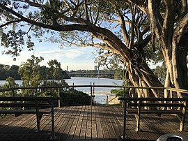 View from Fairfield along Brisbane River towards Eleanor Schonell Bridge, 2017 | |||||||||||||||
 Fairfield | |||||||||||||||
| Coordinates | 27°30′24″S 153°01′24″E / 27.5066°S 153.0233°ECoordinates: 27°30′24″S 153°01′24″E / 27.5066°S 153.0233°E | ||||||||||||||
| Population | 2,980 (2016 census)[1] | ||||||||||||||
| • Density | 2,290/km2 (5,940/sq mi) | ||||||||||||||
| Postcode(s) | 4103 | ||||||||||||||
| Area | 1.3 km2 (0.5 sq mi) | ||||||||||||||
| Time zone | AEST (UTC+10:00) | ||||||||||||||
| Location | 5.8 km (4 mi) S of Brisbane | ||||||||||||||
| LGA(s) | City of Brisbane (Tennyson Ward)[2] | ||||||||||||||
| State electorate(s) | |||||||||||||||
| Federal Division(s) | Moreton | ||||||||||||||
| |||||||||||||||

Fairfield is a suburb of the City of Brisbane, Queensland, Australia.[3] In the 2016 census, Fairfield had a population of 2,980 people.[1]
Geography[]
Fairfield is located 5.8 kilometres (3.6 mi) south of the Brisbane CBD on the Brisbane River. The suburb is mainly residential with house and unit accommodation.
Fairfield is bounded to the north by the South Brisbane Cemetery, to the east by the Beenleigh railway line, to the south by Venner Road and to the west by the median of the Brisbane River.[4]
History[]
Samuel Grimes and brother George Grimes immigrated to Queensland on the Chaseley in 1849, one of the ships chartered by Dr John Dunmore Lang. In 1857 they established an arrowroot farm called Fairfield in the area, providing the name for the suburb.[3]
The Fairfield Baptist Church opened for worship on 24 December (Christmas Eve) 1865 followed by a celebratory luncheon on 26 December (Boxing Day) 1865 as a branch of the Vulture Street Baptist Church. Located on the south-western corner of Dudley Street and Lang Street (now Lagonda Street, 27°30′37″S 153°01′41″E / 27.5102°S 153.0280°E) approximately 1⁄4 mile (0.40 km) west of Ipswich Road, it was large enough to accommodate 90 to 100 people.[5][6] By 1927 it was decided that the church needed a more prominent location, eventually culminating in the relocation of the church building to 470 Ipswich Road, where it was refurbished before re-opening there as Annerley Baptist Church on Saturday 9 February 1935 by Reverend J.C. Farquhar.[7][8][9]
In 1914 the Railside Estate was a subdivision of 28 residential lots for the land bounded by Bell Lane (now Bledisloe Street) to the north, the South Coast railway line to the east, Venner Road to the south, and Cross Street to the west. The estate was described as "within a stones throw from the Fairfield railway station".[10]
Parts of Fairfield were flooded in the 1974 floods.[citation needed]
The Fairfield Library opened in 1988 with a major refurbishment in 2011.[11]
Parts of Fairfield were floods in the January 2011 Brisbane flood.[citation needed]
In the 2016 census, Fairfield had a population of 2,980 people.[1]
Transport[]

There is a Fairfield train station on the line to Beenleigh. The main bus service is the 196, which runs every 15 minutes during the day and commences at Fairfield Gardens. During the morning peak the 107 and 108 bus services are also available. There is also a taxi rank.[citation needed]
Education[]
There are no schools in Fairfield. The nearest government primary schools are in the neighbouring suburbs of Dutton Park, Annerley (Junction Park State School) and Yeronga (Yeronga State School). The nearest government secondary school is in Yeronga.[12]
A new government secondary school, , is expected to open in neighbouring Dutton Park in 2021.[13]
Amenities[]
Fairfield has a Skate Park that caters for young people in the suburb.[citation needed]
Fairfield Gardens is a shopping centre at 180 Fairfield Road. The main shop in the centre is a Coles supermarket. It also has a Fairfield Gardens Chemist (use to be called Terry WHite Chemist), Australia Post, BWS, Dollars and Cents, Doctors surgery and 7-Eleven fuel station.[citation needed]
The Brisbane City Council operates a public library at Fairfield Gardens.[14]
The suburb borders the Brisbane River and has many parks.[citation needed]
Demographics[]
In the 2011 census, Fairfield recorded a population of 2,554 people, 50.2% female and 49.8% male. The median age of the Fairfield population was 31 years of age, 6 years below the Australian median. 69.2% of people living in Fairfield were born in Australia, compared to the national average of 69.8%; the next most common countries of birth were England 3.2%, New Zealand 3.1%, Malaysia 1.5%, China 1.2%, Vietnam 1.2%. 77.3% of people spoke only English at home; the next most popular languages were 2.4% Mandarin, 2% Greek, 1.7% Vietnamese, 1.7% Spanish, 0.9% German.[citation needed]
References[]
- ^ Jump up to: a b c Australian Bureau of Statistics (27 June 2017). "Fairfield (SSC)". 2016 Census QuickStats. Retrieved 20 October 2018.

- ^ "Tennyson Ward". Brisbane City Council. Brisbane City Council. Archived from the original on 4 March 2017. Retrieved 19 March 2017.
- ^ Jump up to: a b "Fairfield – suburb in City of Brisbane (entry 50284)". Queensland Place Names. Queensland Government. Retrieved 25 January 2020.
- ^ "Queensland Globe; Layer:Boundaries".
- ^ "Classified Advertising". The Brisbane Courier. XX (2, 457). Queensland, Australia. 12 December 1865. p. 1. Retrieved 23 May 2021 – via National Library of Australia.
- ^ "Bureau of Industry Queensland flood map of Brisbane and suburbs" (Map). Queensland Government. 1933. Retrieved 23 May 2021.
- ^ "Brisbane and Suburbs Street and Road Map" (Map). Queensland Government. 1943. Retrieved 23 May 2021.
- ^ "FAIRFIELD BAPTIST CHAPEL". The Brisbane Courier. XX (2, 470). Queensland, Australia. 27 December 1865. p. 2. Retrieved 23 May 2021 – via National Library of Australia.
- ^ "NEW CHURCH". Sunday Mail (611). Queensland, Australia. 10 February 1935. p. 9. Retrieved 23 May 2021 – via National Library of Australia.
- ^ "Railside Estate". State Library of Queensland. 1914. hdl:10462/deriv/18564. Cite journal requires
|journal=(help) - ^ "Public Libraries Statistical Bulletin 2016-17" (PDF). Public Libraries Connect. State Library of Queensland. November 2017. p. 11. Archived (PDF) from the original on 30 January 2018. Retrieved 30 January 2018.
- ^ "Queensland Globe". State of Queensland. Retrieved 13 March 2020.
- ^ Moore, Tony (1 April 2019). "First look at Brisbane's new inner-city high school at Dutton Park". Brisbane Times. Retrieved 13 March 2020.
- ^ "Library opening hours and locations". Brisbane City Council. 3 January 2018. Archived from the original on 30 January 2018. Retrieved 30 January 2018.
Further reading[]
- Jones, E. S (1965), Annerley Baptist Church : one hundred years of Christian witness in the district, 1865-1965, Annerley Baptist Church – includes the history of Fairfield Baptist Church
External links[]
| Wikimedia Commons has media related to Fairfield, Queensland. |
- Suburbs of the City of Brisbane