Geography of Sudan
Coordinates: 15°00′N 30°00′E / 15.000°N 30.000°E


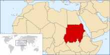
Sudan is located in Northeast Africa. It is bordered by Egypt to the north, the Red Sea to the northeast, Eritrea and Ethiopia to the east, South Sudan to the south, the Central African Republic to the southwest, Chad to the west and Libya to the northwest. Sudan is the third largest country in Africa, after Algeria and the Democratic Republic of the Congo. It had been the largest country on the continent until the 2011 independence of South Sudan.
Geographical regions[]

Northern Sudan, lying between the Egyptian border and Khartoum, has two distinct parts, the desert and the Nile Valley.[1] To the east of the Nile lies the Nubian Desert; to the west, the Libyan Desert.[1] They are similar—stony, with sandy dunes drifting over the landscape.[1] There is virtually no rainfall in these deserts, and in the Nubian Desert there are no oases.[1] In the west, there are a few small watering holes, such as , where the water table reaches the surface to form wells that provide water for nomads, caravans, and administrative patrols, although insufficient to support an oasis and inadequate to provide for a settled population.[1] Flowing through the desert is the Nile Valley, whose alluvial strip of habitable land is no more than two kilometers wide and whose productivity depends on the annual flood.[1]
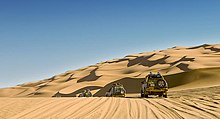
Sudan's western front encompasses the regions known as Darfur and Kurdufan that comprise 850,000 square kilometers.[1] Traditionally, this has been regarded as a single regional unit despite the physical differences.[1] The dominant feature throughout this immense area is the absence of perennial streams; thus, people and animals must remain within reach of permanent wells.[1] Consequently, the population is sparse and unevenly distributed.[1] Western Darfur is an undulating plain dominated by the volcanic massif of Jabal Marrah towering 900 meters above the Sudanic plain; the drainage from Jabal Marrah onto the plain can support a settled population and a variety of wildlife (see East Saharan montane xeric woodlands).[1] Western Darfur stands in contrast to northern and eastern Darfur, which are semidesert with little water either from the intermittent streams known as wadis or from wells that normally go dry during the winter months.[1] Northwest of Darfur and continuing into Chad lies the unusual region called the , where sporadic winter rains generated from the Mediterranean frequently provide excellent grazing into January or even February.[1] The southern region of western Sudan is known as the qoz, a land of sand dunes that in the rainy season is characterized by a rolling mantle of grass and has more reliable sources of water with its bore holes and hafri (sing., ) than does the north.[1] A unique feature of western Sudan is the Nuba mountain range of southeast Kurdufan in the center of the country, a conglomerate of isolated dome-shaped, sugarloaf hills that ascend steeply and abruptly from the great Sudanic plain.[1] Many hills are isolated and extend only a few square kilometers, but there are several large hill masses with internal valleys that cut through the mountains high above the plain.[1]
Sudan's third distinct region is the central clay plains that stretch eastward from the Nuba Mountains to the Ethiopian frontier, broken only by the , and from Khartoum in the north to the far reaches of southern Sudan.[1] Between the Dindar and the Rahad rivers, a low ridge slopes down from the Ethiopian highlands to break the endless skyline of the plains, and the occasional hill stands out in stark relief.[1] The central clay plains provide the backbone of Sudan's economy because they are productive where settlements cluster around available water.[1] Furthermore, in the heartland of the central clay plains lies the jazirah, the land between the Blue Nile and the White Nile (literally in Arabic "peninsula") where the great Gezira Scheme (a.k.a. Jazirah Scheme) was developed.[1] This project grows cotton for export and has traditionally produced more than half of Sudan's revenue and export earnings.[1]
Northeast of the central clay plains lies eastern Sudan, which is divided between desert and semidesert and includes the Butana, the Qash Delta, the Red Sea Hills, and the coastal plain.[1] The Butana is an undulating land between Khartoum and Kassala that provides good grazing for cattle, sheep, and goats.[1] East of Al Butanah is a peculiar geological formation known as the Qash Delta.[1] Originally a depression, it has been filled with sand and silt brought down by the flash floods of the Qash River, creating a delta above the surrounding plain.[1] Extending 100 kilometers north of Kassala, the whole area watered by the Qash is a rich grassland with bountiful cultivation long after the river has spent its waters on the surface of its delta.[1] Trees and bushes provide grazing for the camels from the north, and the rich moist soil provides an abundance of food crops and cotton.[1]
Northward beyond the Qash lie the more formidable Red Sea Hills.[1] Dry, bleak, and cooler than the surrounding land, particularly in the heat of the Sudan summer, they stretch northward into Egypt, a jumbled mass of hills where life is hard and unpredictable for the hardy Beja inhabitants.[1] Below the hills sprawls the coastal plain of the Red Sea, varying in width from about fifty-six kilometers in the south near Tawkar to about twenty-four kilometers near the Egyptian frontier.[1] The coastal plain is dry and barren.[1] It consists of rocks, and the seaward side is thick with coral reefs.[1]
Sudan includes islands located in the Nile (including Aba Island, Badien Island, Sai Island, and, at the confluence of the Blue and White Nile, Tuti Island) and in the Red Sea (including the Suakin Archipelago).[citation needed]
Political geography[]
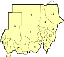
Sudan is divided into 18 states and one area with special administrative status. The states of Sudan are:
- Khartoum
- North Kordofan
- Northern
- Kassala
- Blue Nile
- North Darfur
- South Darfur
- South Kordofan
- Gezira
- White Nile
- River Nile
- Red Sea
- Al Qadarif
- Sennar
- West Darfur
- Central Darfur
- East Darfur
- West Kordofan (disestablished in 2005; reestablished in 2013)[2][3]
As a result of the Comprehensive Peace Agreement signed in 2005, the Abyei Area was given special administrative status and following the independence of South Sudan in 2011, is considered to be simultaneously part of both the Republic of Sudan and the Republic of South Sudan, effectively a condominium.
Soils[]

The country's soils can be divided geographically into two categories.[4] These are the sandy soils of the northern and west central areas, the clay soils of the central region, and the laterite soils of the south.[4] Less extensive and widely separated, but of major economic importance, is a third group consisting of alluvial soils found along the lower reaches of the White Nile and Blue Nile rivers, along the main Nile to Lake Nubia, in the delta of the Qash River in the Kassala area, and in the Baraka Delta in the area of Tawkar near the Red Sea in Ash Sharqi State.[4]
Agriculturally, the most important soils are the clays in central Sudan that extend from west of Kassala and southern Kurdufan.[4] Known as cracking soils because of the practice of allowing them to dry out and crack during the dry months to restore their permeability, they are used in the areas of Al Jazirah and for irrigated cultivation.[4] East of the Blue Nile, large areas are used for mechanized rainfed crops.[4] West of the White Nile, these soils are used by traditional cultivators to grow sorghum, sesame, peanuts, and (in the area around the Nuba Mountains) cotton.[4] The southern part of the clay soil zone lies in the broad floodplain of the upper reaches of the White Nile and its tributaries, covering most of Aali an Nil and upper Bahr al Ghazal states.[4] Subject to heavy rainfall during the rainy season, the floodplain proper is inundated for four to six months — a large swampy area, the Sudd in South Sudan, is permanently flooded — and adjacent areas are flooded for one or two months.[4] In general this area is poorly suited to crop production, but the grasses it supports during dry periods are used for grazing.[4]
The sandy soils in the semiarid areas south of the desert in northern Kurdufan and northern Darfur states support vegetation used for grazing.[4] In the southern part of these states and the western part of southern Darfur are the so-called qoz sands.[4] Livestock raising is this area's major activity, but a significant amount of crop cultivation, mainly of pearl millet, also occurs.[4] Peanuts and sesame are grown as cash crops.[4] The qoz sands are the principal area from which gum arabic is obtained through tapping of Acacia senegal (known locally as hashab).[4] This tree grows readily in the region, and cultivators occasionally plant hashab trees when land is returned to fallow.[4]
Hydrology[]
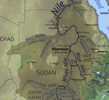
Except for a small area in northeastern Sudan, where wadis discharge the sporadic runoff into the Red Sea or rivers from Eritrea flow into shallow evaporating ponds west of the Red Sea Hills, the entire country is drained by the Nile and its two main tributaries, the Blue Nile and the White Nile.[5] The longest river in the world, the Nile flows for 6,737 kilometers from its farthest headwaters in central Africa to the Mediterranean.[5] The importance of the Nile has been recognized since biblical times; for centuries the river has been a lifeline for Sudan.[5]
The Blue Nile flows out of the Ethiopian highlands to meet the White Nile at Khartoum.[5] The Blue Nile is the smaller of the two rivers; its flow usually accounts for only one-sixth of the total.[5] In August, however, the rains in the Ethiopian highlands swell the Blue Nile until it accounts for 90 percent of the Nile’s total flow.[5] Sudan has constructed several dams to regulate the river’s flow, including the Roseires Dam, about 100 kilometers from the Ethiopian border and the largest, the 40-meter-high Sinnar Dam constructed in 1925 at Sinnar.[5][6] The Blue Nile’s two main tributaries, the Dindar and the Rahad, have headwaters in the Ethiopian highlands and discharge water into the Blue Nile only during the summer high-water season.[5] For the remainder of the year, their flow is reduced to pools in sandy riverbeds.[5]
The White Nile flows north from central Africa, draining Lake Victoria and highland regions of Uganda, Rwanda, and Burundi.[5] South of Khartoum, the British built the Jabal al-Awliya Dam in 1937 to store the water of the White Nile and then release it in the fall when the flow from the Blue Nile slackens.[5] Much water from the reservoir has been diverted for irrigation projects in central Sudan, however, and much of the remainder evaporates.[5] By now, silt deposits have curtailed the overall flow.[5]
North of Khartoum, the Nile flows through the desert in a large S-shaped pattern to empty into Lake Nasser behind the Aswan High Dam in Egypt.[5] The river flows slowly beyond Khartoum, dropping little in elevation, although five cataracts hinder river transport at times of low water.[5] The Atbarah River, flowing out of Ethiopia, is the only tributary north of Khartoum, and its waters reach the Nile for only the six months between July and December.[5] During the rest of the year, the Atbarah’s bed is dry, except for a few pools and ponds.[5]
Climate[]

Although Sudan lies within the tropics, the climate ranges from hyper-arid in the north to tropical wet-and-dry in the far southwest.[7] Temperatures do not vary greatly with the season at any location; the most significant climatic variables are rainfall and the length of the wet and dry seasons.[7] Variations in the length of the wet and dry seasons depend on which of two air flows predominates: dry northern winds from the Sahara and the Arabian Peninsula or moist southwesterly winds from the Congo River basin and southeasterly winds from the Indian Ocean.[7]
From January to March, the country is under the influence of dry northeasterlies.[7] There is minimal rainfall countrywide except for a small area in northwestern Sudan where the winds have passed over the Mediterranean bringing occasional light rains.[7] By early April, the moist southwesterlies have reached southern Sudan, bringing heavy rains and thunderstorms.[7] By July, the moist air has reached Khartoum, and in August it extends to its usual northern limits around Abu Hamad, although in some years the humid air may even reach the Egyptian border.[7] The flow becomes weaker as it spreads north.[7] In September the dry northeasterlies begin to strengthen and to push south and by the end of December they cover the entire country.[7] Khartoum has a three-month rainy season (July–September) with an annual average rainfall of 161 millimeters (6.3 in); Atbarah receives showers in August that produce an annual average of only 74 millimetres (2.9 in) millimeters.[7]
In some years, the arrival of the southwesterlies and their rain in central Sudan can be delayed, or they may not come at all.[7] If that happens, drought and famine follow.[7] The decades of the 1970s and 1980s saw the southwesterlies frequently fail, with disastrous results for the Sudanese people and economy.[7]
Temperatures are highest at the end of the dry season when cloudless skies and dry air allow them to soar.[7] The far south, however, with only a short dry season, has uniformly high temperatures throughout the year.[7] In Khartoum, the warmest months are May and June, when average highs are 41 °C (105.8 °F) and temperatures can even reach 48 °C (118.4 °F).[7] Northern Sudan, with its short rainy season, has very high daytime temperatures year round, except for winter months in the northwest where there is some precipitation in January and February.[7] Conditions in highland areas are generally cooler, and the hot daytime temperatures during the dry season throughout central and northern Sudan fall rapidly after sunset.[7] Lows in Khartoum average 15 °C (59 °F) in January and have dropped as low as 6 °C (42.8 °F) after the passing of a cool front in winter.[7]
The haboob, a violent dust storm, can occur in central Sudan when the moist southwesterly flow first arrives (May through July).[7] The moist, unstable air forms thunderstorms in the heat of the afternoon.[7] The initial downflow of air from an approaching storm produces a huge yellow/red wall of sand and clay that can temporarily reduce visibility to zero.[7]
Desert regions in central and northern Sudan are among the driest and the sunniest places on Earth : the sunshine duration is always uninterrupted year-round and soar to above 4,000 h in the best cases, or about 91% of the time and the sky is cloudless all the time.[citation needed] Areas around Wadi Halfa and along the Egyptian border can easily pass many years or many decades without seeing any rainfall at all.[citation needed] They are also among the hottest places during their summertime and their "wintertime" : averages high temperatures routinely exceed 40 °C (104 °F) for four to nearly six months a year to reach a maximum peak of about 45 °C (113 °F) in some places and averages high temperature remain above 24 °C (75.2 °F) in the northernmost region and above 30 °C (86 °F) in places such as Atbara or Meroe.[citation needed]
Environmental issues[]
Sudan faces some severe environmental problems, most related either to the availability of water or its disposal.[5] Among them are desertification, land degradation, and deforestation.[5] Desertification, the southward shift of the boundary between desert and semidesert, has occurred at an estimated rate of 50 to 200 kilometers since records of rainfall and vegetation began in the 1930s.[5] Its impact has been most notable in North Darfur and North Kordofan.[5] Desertification is likely to continue its southward progression because of declining precipitation and will lead to continued loss of productive land.[5] Agriculture, particularly poorly planned and managed mechanized agriculture, has led to land degradation, water pollution, and related problems.[5] Land degradation has also resulted from an explosive growth in the size of livestock herds since the 1960s that has overtaxed grazing areas.[5] Deforestation has occurred at an alarming rate.[5] Sudan as a whole might have lost nearly 12 percent of its forest cover between 1990 and 2005, or about 8.8 million hectares, a loss driven primarily by land clearance and energy needs.[5]
Compounding Sudan’s environmental problems are long years of warfare and the resultant camps for large numbers of internally displaced people, who scour the surrounding land for water, fuel, and food.[5] United Nations (UN) experts predict that riverbank erosion and loss of fertilizing silt will occur from Sudan’s current ambitious program of dam construction on the Nile and its tributaries.[5] In urban areas, rapid and uncontrolled population influx into Khartoum and other cities and towns and the general lack of facilities to manage solid waste and sewage are among major environmental concerns.[5]
Area and land use[]
Sudan has a land area of 1,731,671 square kilometres (668,602 sq mi) and a total area of 1,861,484 square kilometres (718,723 sq mi).[8] Approximately 18,900 square kilometres (7,300 sq mi) was irrigated as of 2012.[8]
Land boundaries[]
The length of Sudan's borders is 6,819 kilometres (4,237 mi).[8] Border countries are Central African Republic (174 km (108 mi)), Chad (1,403 km (872 mi)), Egypt (1,276 km (793 mi)), Eritrea (682 km (424 mi)), Ethiopia (744 km (462 mi)), Libya (382 km (237 mi)), and South Sudan (2,158 km (1,341 mi)).[8]
Natural resources[]
Petroleum is Sudan's major natural resource. The country also has significant deposits of chromium ore, copper, iron ore, mica, silver, gold, tungsten, and zinc.
The Nile is the dominant geographic feature of Sudan, flowing 3,000 kilometers from Uganda in the south to Egypt in the north. Most of the country lies within its catchment basin. The Blue Nile and the White Nile, originating in the Ethiopian highlands and the Central African lakes, respectively, join at Khartoum to form the Nile River proper that flows to Egypt. Other major tributaries of the Nile are the Bahr el Ghazal, Sobat, and Atbarah rivers.
See also[]
References[]
- ^ Jump up to: a b c d e f g h i j k l m n o p q r s t u v w x y z aa ab ac ad ae af Bechtold, Peter K. (2015). "Geographic regions" (PDF). In Berry, LaVerle (ed.). Sudan: a country study (5th ed.). Washington, D.C.: Federal Research Division, Library of Congress. pp. 63–66. ISBN 978-0-8444-0750-0.
 This article incorporates text from this source, which is in the public domain. Though published in 2015, this work covers events in the whole of Sudan (including present-day South Sudan) until the 2011 secession of South Sudan.CS1 maint: postscript (link)
- ^ "Western Kordofan State". Archived from the original on August 12, 2013.
- ^ "Sudan shuffles governors of Kordofan states including ICC suspect - Sudan Tribune: Plural news and views on Sudan". www.sudantribune.com.
- ^ Jump up to: a b c d e f g h i j k l m n o p Bechtold, Peter K. (2015). "Soils" (PDF). In Berry, LaVerle (ed.). Sudan: a country study (5th ed.). Washington, D.C.: Federal Research Division, Library of Congress. pp. 66–67. ISBN 978-0-8444-0750-0. This article incorporates text from this source, which is in the public domain. Though published in 2015, this work covers events in the whole of Sudan (including present-day South Sudan) until the 2011 secession of South Sudan.CS1 maint: postscript (link)
- ^ Jump up to: a b c d e f g h i j k l m n o p q r s t u v w x y z aa ab ac Bechtold, Peter K. (2015). "Hydrology" (PDF). In Berry, LaVerle (ed.). Sudan: a country study (5th ed.). Washington, D.C.: Federal Research Division, Library of Congress. pp. 67–70. ISBN 978-0-8444-0750-0. This article incorporates text from this source, which is in the public domain. Though published in 2015, this work covers events in the whole of Sudan (including present-day South Sudan) until the 2011 secession of South Sudan.CS1 maint: postscript (link)
- ^ "Water infrastructure in the Nile Basin" (PDF). Food and Agriculture Organization. July 19, 2011. Metadata about the map is available here.CS1 maint: postscript (link)
- ^ Jump up to: a b c d e f g h i j k l m n o p q r s t u v Bechtold, Peter K. (2015). "Climate" (PDF). In Berry, LaVerle (ed.). Sudan: a country study (5th ed.). Washington, D.C.: Federal Research Division, Library of Congress. pp. 70–71. ISBN 978-0-8444-0750-0. This article incorporates text from this source, which is in the public domain. Though published in 2015, this work covers events in the whole of Sudan (including present-day South Sudan) until the 2011 secession of South Sudan.CS1 maint: postscript (link)
- ^ Jump up to: a b c d "Sudan". World Factbook. Central Intelligence Agency. Retrieved 2020-10-20.
- Geography of Sudan