Geography of Nigeria


Nigeria is a country in West Africa. Nigeria shares land borders with the Republic of Benin in the west, Chad and Cameroon in the east, and Niger in the north. Its coast lies on the Gulf of Guinea in the south and it borders Lake Chad to the northeast. Noted geographical features in Nigeria include the Adamawa Plateau, Mambilla Plateau, Jos Plateau, Obudu Plateau, the Niger River, Benue River, and Niger Delta.
Nigeria is found in the tropics, where the climate is seasonally damp and very humid. Nigeria is affected by four climate types; these climate types are generally gradated from south to north.
Climate[]

The tropical monsoon climate, designated by the Köppen climate classification as "Am", is found in the southern part of the country. This climate is influenced by the monsoons originating from the South Atlantic Ocean, which are brought into the country by the (maritime tropical) MT air mass, a warm moist sea-to-land seasonal wind. Its warmth and high humidity gives it a strong tendency to ascend and produce copious rainfall, which is a result of the condensation of water vapour in the rapidly rising air.[1] The tropical monsoon climate has a very small temperature range. Then temperature ranges are almost constant throughout the year; for example, Warri in the southern part of Nigeria records a maximum of 28 °C (82.4 °F) for its hottest month while its lowest temperature is 26 °C (78.8 °F) in its coldest month.
The southern part of Nigeria experiences heavy and abundant rainfall. These storms are usually convectional in nature because of the region's proximity to the equatorial belt. The annual rainfall received in this region is very high. The Niger Delta receives over 4,000 mm (157.5 in) of rain annually. The rest of the southeast receives between 2,000 and 3,000 mm (118.1 in) of rain per year. The southern region of Nigeria experiences a double rainfall maxima characterised by two high rainfall peaks, with a short dry season and a longer dry season falling between and after each peaks. The first rainy season begins around March and last to the end of July with a peak in June, this rainy season is followed by a short dry break in August known as the August break which is a short dry season lasting for two to three weeks in August. This break is broken by the short rainy season starting around early September and lasting to mid October with a peak period at the end of September. The ending of the short rainy season in October is followed by long dry season. This period starts from late October and lasts until early March with peak dry conditions between early December and late February.[2]

The tropical savanna climate (Aw) or tropical wet and dry climate is extensive in area and covers most of western to central Nigeria, where it exerts enormous influence on the region. This climate makes up the vast majority of the country and is marked by distinct rainy and dry seasons with a single peak known as the summer maximum. Temperatures are above 18 °C (64 °F) throughout the year. Abuja, Nigeria's capital city found in central Nigeria, has a temperature range of 18.45 °C (65.21 °F) to 36.9 °C (98.4 °F) and an annual rainfall of about 1,500 mm (59.1 in) with a single rainfall maxima in September.[3] The dry season occurs from December to March and is hot and dry with the Harmattan wind, a continental tropical (CT) air mass laden with dust from the Sahara, prevailing throughout this period.
With the Intertropical Convergence Zone swinging northward over West Africa from the Southern Hemisphere in April, heavy showers coming from pre-monsoonal convective clouds mainly in the form of squall lines also known as the north easterlies formed mainly as a result of the interactions of the two dominant airmasses in Nigeria known as the maritime tropical (south westerlies) and the continental tropical (north easterlies),[4] begins in central Nigeria while monsoons arrive in July, bringing with it high humidity, heavy cloud cover and heavy rainfall lasting till September when the monsoons gradually begin retreating southward to the southern part of Nigeria. Rainfall totals in central Nigeria varies from 1,100 mm (43.3 in) in the lowlands to over 2,000 mm (78.7 in) along the south western escarpment of the Jos Plateau.[5]
A hot semi-arid climate (BSh) is predominant within the Sahel in the northern part of Nigeria. Annual rainfall totals are low. The rainy season in the northern part of Nigeria lasts for three to four months (June–September). The rest of the year is hot and dry with temperatures climbing as high as 40 °C (104.0 °F) . Potiskum, Yobe State in the northeast of Nigeria recorded Nigeria’s lowest ever temperature of 2.8 °C (37.0 °F).
Alpine climate or highland climate or mountain climate are found on highlands regions in Nigeria. Highlands with the alpine climate in Nigeria, are well over 1,520 metres (4,987 ft) above sea level. Because of the location in the tropics, this elevation is high enough to reach the temperate climate line in the tropics thereby giving the highlands, mountains and the plateau regions standing above this height, a cool mountain climate.
Rainfall[]
Rainfall in the coastal belt of the Niger Delta is heavy due to the closeness of the Delta region to the equator. Annual rainfall totals vary from 2,400 to over 4,000 millimeters.
Niger Delta cities and their annually rainfall totals in millimeters:
- Warri — 2,730 mm
- Forcados (coastal town in the Niger Delta) — 4,870 mm
- Port Harcourt — 2,400 mm
- Calabar (coastal city) — 3,070 mm (rainiest city with over one million people in Nigeria)
- Bonny (south of Port Harcourt) — 4,200 mm
Trade winds[]
Tropical maritime air mass[]
The tropical maritime air mass (MT) is responsible for Nigeria's rainy season. This wind begins in February in the southern part of Nigeria while it takes longer for the wind to fully cover the whole of the country, reaching the northern part of Nigeria in June. Its presence a result of the northward retreat of the Harmattan. The northward retreat of the tropical continental air mass (CT) is caused by the sun's northward shift from the tropic of capricorn in the southern hemisphere to the tropic of cancer in the northern hemisphere. This shift begins from February and ends in June, when the sun is fully overhead at the tropic of cancer. During this northward migration of the sun as a result of the earth tilting along its axis, the sun crosses the equator (around March), moving over West Africa. West Africa comes directly under the sun at this time. The whole of West Africa is heated intensely as result of the increased insolation. Temperatures can climb as high as 35 °C (95.0 °F) over West Africa during this time. Temperatures in the northern part of Nigeria can go as high as 48 °C (118.4 °F) in cities like Maiduguri.[6]
The high temperatures coupled with an increase in insolation cause a region of low pressure to develop over West Africa and Nigeria between March to May. The tropical continental air mass from the Sahara is weakened by the overheating of the land surface. This transfer of heat in turn causes the atmosphere to expand and become lighter. The air mass loses its strength around February in the southern part of Nigeria to June in northern Nigeria and begins to retreat coupled with the rising of air in form of convection within this air mass, further weakening the dominance of the wind over West Africa. The air mass finally retreats from most of Nigeria around April to May. The sun's rays enters into the atmosphere of Nigeria more intense than it does during the Harmattan, which contains dust and haze.[7] The heating of the West Africa land mass creates a low pressure region over West Africa. This low pressure zone aid in the development of the tropical maritime air mass from the south Atlantic.
The tropical maritime air mass is a warm, humid and unstable trade wind. Convection currents form within the airmass whenever there is little instability in the airmass as a result of a slight to a very high orographic uplift in mountainous regions like the Obudu Plateau or the heating of the land which can trigger the formation of cumulonimbus cloud leading to thunderstorms within the air mass. During the dominance of the tropical maritime air mass, mornings are bright and sunny, the sun's heating of the land in the mornings and afternoons sets up convectional currents, these currents rise vertically, cumulonimbus clouds are formed, and torrential downpours can occur in the afternoon.
The African easterly wave is another major contributor of rainfall during the summer monsoons months of May to September. The nature of this wave changes at about 15 degrees north latitude. The waves that pass south of this latitiude carry moisture and create convection that leads to rain clouds.[8][9] Nigeria's location in the wetter part of the easterly waves south of the 15 degrees north latitude creates wetter climatic conditions for Nigeria, especially during the monsoons.
Tropical continental air mass[]
The tropical continental air mass, locally known as the Harmattan, is a wind originating from North Africa which crosses the Sahara into West Africa. This air mass dominates Nigeria's climate during the dry season from December to March. The tropical continental air mass is dusty and creates a haze within the atmosphere when it predominates. The haze is as a result of the dust within the air mass limiting visibility and blocking much of the sun's rays from reaching the earth. It is also a dry air mass formed over land in an area close to the equator. The air mass generally has no precipitation since it forms in the Sahara, generating dust rather than moisture. The air mass creates low visibility which hampers transportation, but its presence brings some relief to farmers since the low humidity present in the air quickens the drying of their crops.
Temperature[]
Nigeria's seasons and temperature variance are determined by rainfall with rainy season and dry season being the major seasons in Nigeria. The rainy season of Nigeria brings in cooler weather to the country as a result of an increased cloud cover that acts as a blockage of the intense sunshine of the tropics by blocking much of the suns rays in the rainy season; this in turn cools the land, and the winds above the ground remain cool thereby making for cooler temperatures during the rainy season. But afternoons in the rainy season can be hot and humid. In the rainy season it is damp, and the rainfalls are usually abundant.
The dry season of Nigeria is a period of little cloud cover in the southern part of Nigeria to virtually no cloud cover in the northern part of Nigeria. The sun shines through the atmosphere with little obstructions from the clear skies making the dry season in Nigeria a period of warm weather conditions. In the middle of the dry season around December, the dust brought in by the Harmattan partially blocks the sun's rays, which lowers temperatures. But with the withdrawal of this wind around March to April following the onset of the rainy season, temperatures can go as high as 44 °C (111.2 °F) in some parts of Nigeria.[10]
Semi-temperate weather conditions prevail on the highlands in central Nigeria above 1,200 metres (3,937 ft) above sea level, namely the Jos Plateau. Temperatures on the Jos plateau ranges between 16 °C to 25 °C which are cool all year round. Temperate weather conditions occur on the highlands along the Nigeria Cameroon border, in the eastern part of Nigeria. Highlands in these region attain an average height of more than 1,524 m (5,000 ft) to some standing above 2,000 metres (6,562 ft) above sea level. The climate on these highlands is temperate all year round. The major highlands in this region are the Obudu Plateau above 1,584 m (5,197 ft), Mambilla Plateau above 1,524 m (5,000 ft) and Mt. Chappal Waddi above 2,000 m (6,562 ft).
Topography[]
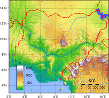
Nigeria's most expansive topographical region is that of the Niger and Benue River valleys, which merge into each other and form a "y" shaped confluence at Lokoja.[11] Plains rise to the north of the valleys. To the southwest of the Niger there is "rugged" highland, and to the southeast of the Benue hills and mountains are found all the way to the border with Cameroon. Coastal plains are found in both the southwest and the southeast.
Niger Delta[]
The Niger Delta is located in the southern part of Nigeria. It is one of the world's largest arcuate fan-shaped river deltas. The riverine area of the Niger Delta is a coastal belt of swamps bordering the Atlantic. The mangrove swamps are vegetated tidal flats formed by a reticulate pattern of interconnected meandering creeks and tributaries of the Niger River. About 70% of Nigeria's crude oil and gas production is from the area. A recent global remote sensing analysis suggested that there were 1,244km² of tidal flats in Nigeria, making it the 27th ranked country in terms of tidal flat area.[12]
Vegetation[]

Nigeria is covered by three types of vegetation: forests (where there is significant tree cover), savannahs (insignificant tree cover, with grasses and flowers located between trees), and montane land (least common and mainly found in the mountains near the Cameroon border. Both the forest zone and the savannah zone are divided into three parts.[13]
Some of the forest zone's most southerly portion, especially around the Niger River and Cross River deltas, is mangrove swamp. North of this is fresh water swamp, containing different vegetation from the salt water mangrove swamps, and north of that is rain forest.[13]
The savannah zone's three categories are divided into Guinean forest-savanna mosaic, made up of plains of tall grass which are interrupted by trees, the most common across the country; Sudan savannah, with short grasses and short trees; and Sahel savannah patches of grass and sand, found in the northeast.[13]
Natural resources and land use[]
Nigeria's natural resources include but are not limited to petroleum, tin, columbite, iron ore, coal, limestone, lead, zinc, natural gas, hydropower, and arable land.
Extreme points[]
This is a list of the extreme points of Nigeria, the points that are farther north, south, east or west than any other location.
- Northernmost point – unnamed location on the border with Niger immediately northwest of the town of , Sokoto State.
- Easternmost point – unnamed location on the border with Cameroon immediately east of the village of , Borno State.
- Southernmost point – unnamed headland south of the town of , Bayelsa State.
- Westernmost point – unnamed location on the border with Benin Republic immediately east of the Beninoise town of , Oyo State.
See also[]
References[]
- ^ "Monsoon - meteorology". Encyclopaedia Britannica.
- ^ "Archived copy". Archived from the original on 2011-05-11. Retrieved 2011-05-27.CS1 maint: archived copy as title (link)
- ^ http://iahs.info/redbooks/a281/iahs_281_277.pdf
- ^ Adedoyin, J. A. (1989). "Initiation of West African squall lines". Meteorology and Atmospheric Physics. 41: 99–103. doi:10.1007/BF01043455.
- ^ "Jos Plateau forest-grassland mosaic". Terrestrial Ecoregions. World Wildlife Fund.
- ^ http://sunday.dailytrust.com/index.php?option=com_content&view=article&id=3565:maiduguri-residents-how-we-cope-under-harsh-48-degree-celsius&catid=41:latest-news&Itemid=26 Archived 2011-08-30 at the Wayback Machine
- ^ "Nigeria: Late dust (harmattan) storm covers the country (Google / AP)". wordpress.com. 25 March 2010.
- ^ College Park MD (SPX) (Jun 11, 2004). "EARTH OBSERVATION Researchers Seeing Double On African Monsoons". SPACE MEDIA NETWORK PROMOTIONS. Retrieved 27 May 2011.
- ^ "About the Country Nigeria". CANUK. 2011. Archived from the original on 16 March 2011. Retrieved 27 May 2011.
- ^ "Archived copy". Archived from the original on 2011-03-26. Retrieved 2011-05-03.CS1 maint: archived copy as title (link)
- ^ "Nigeria". Encarta. Microsoft. Archived from the original on 2009-10-28. Retrieved 2007-07-19.
- ^ Murray, N.J.; Phinn, S.R.; DeWitt, M.; Ferrari, R.; Johnston, R.; Lyons, M.B.; Clinton, N.; Thau, D.; Fuller, R.A. (2019). "The global distribution and trajectory of tidal flats". Nature. 565: 222–225. doi:10.1038/s41586-018-0805-8.
- ^ Jump up to: a b c "The Human and Physical Characteristics of Nigeria". Geographical Alliance of Iowa. University of Northern Iowa. Archived from the original on 2010-03-28. Retrieved 2007-08-13.

- Geography of Nigeria