Geography of Somaliland
This article needs additional citations for verification. (June 2021) |
  | |
| Region | Horn of Africa |
|---|---|
| Coordinates | 9°45′00″N 45°58′00″E / 9.75°N 45.966667°E |
| Area | Ranked 90nd |
| • Total | 176,120 km2 (68,000 sq mi) |
| Coastline | 850,800 km (528,700 mi) |
| Borders | Total land borders:[1] 60 km (37 mi) 766 km (476 mi) 402 km (250 mi) |
| Highest point | Shimbiris 2,460 m (8,070.9 ft) |
| Lowest point | Guban −100 m (−328 ft)[2] |
| Climate | Arid, Semi-arid |
| Exclusive economic zone | 70,000 km2 (27,000 sq mi) |

Somaliland is an unrecognised sovereign state in the Horn of Africa, internationally considered to be part of Somalia.[3]
Somaliland is located in the East African sub-continent between the equator and the Gulf of Aden. The country occupies an area of approximately 176,120 square kilometres (68,000 sq mi). The climate is mostly hot and desertlike; it is largely arid with some semi-arid regions.[4][5]
Land boundaries[]

To the north of Somaliland is the Gulf of Aden, which borders Somaliland along its only of coastline. In its north-western corner, Somaliland shares a border with Djibouti. Ethiopia borders the country to the west and to the south. Somalia, which claims sovereignty over the territory of Somaliland, lies to the east.[6][7]
Topography[]

Somaliland is occupied by three main topographic areas. In the north and northwest, along the Gulf of Aden, lie the costal plains of the Guban region. The plains are a low region that are, on average, just 500 metres above sea level. The low altitude of the region makes it hot and dry, and it receives little rain throughout the year. The Guban contains the port cities of Berbera and Zeylac. The highlands are cool and wet area in the center of Somaliland that contain a series of mountain ranges. To the west are the Golis Mountains and to the east, the Ogo Mountains. The highest peak is found on Mount Shimbiris of the Cal Madow range, with a hight of 2,460 metres (8,070 ft).[8] Borama is one of the major cities located in the mountainous region. In the southeast, near the border with Somalia, is a low region of valleys. The valleys are hot and dry, and receive relatively small amounts of rain each year. The average elevation of the area is between 500 and 1000 metres above sea level. Notable cities in the area include Laascaanood, Taleex, and Xudun.[9]
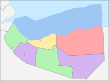
Somaliland Regions[]
The area of the regions of Somaliland is set out in the table below.
| Rank | Name | Area |
|---|---|---|
| 1 | Awdal Region | 16,294 km2 |
| 2 | Sahil Region | 13,930 km2 |
| 3 | Maroodi Jeh Region | 17,429 km2 |
| 4 | Togdheer Region | 30,426 km2 |
| 5 | Sanaag Region | 54,231 km2 |
| 6 | Sool Region | 39,240 km2 |
Climate[]

Somaliland lies north of the Equator and has a dry climate, with most regions designated as arid, with a few, smaller, areas as semi-arid. The temperatures in the highlands range from around 20–24 °C (68–75 °F). In the lower regions such as the valleys and costal plains, the average temperatures are in the higher range of 28–35 °C (82–95 °F).[10][9]
Most regions in Somaliland experience an average of 14.5 inches (370 mm) per year. The primary rainy season is during the spring, with a secondary, more limited, season in late fall. Most of the annual rainfall is concentrated in the highland and plateaux regions of the country, which both receive an average of 300–600 millimetres (12–24 in) per year.[11][12]
Somaliland experiences four seasons of climate. Gu (spring) is the longest wet season, and lasts from late March to early June. The increased rain at this time usually corresponds to abundant water and increased breeding of livestock. Xagaa (summer) is a dry windy season, that typically lasts from June through September. Deyr (fall) is the shorter rainy season which covers late September through November. Jiilaal (winter) is the long dry season which lasts from December until mid-March. Jiilaal is the coolest period of the year in Somaliland, but still brings relatively high amounts of humidity.[9]
Coastline[]
Somaliland has a total coastline of 850 kilometres (530 mi), along the Gulf of Aden. In February 2017, Somaliland declared a 200 miles (320 km) Exclusive Economic Zone and a 24 nautical mile Contiguous Zone in addition to its claimed territorial waters. Internationally, however, the waters are still recognized as belonging to Somalia.[9][13]
See also[]
References[]
- ^ "Somaliland Boundaries". www.somalilandlaw.com.
- ^ "Guban | plain, Somalia | Britannica".
- ^ "Somalia/Somaliland: the differences and issues explained". www.actionaid.org.uk. Retrieved 2021-07-26.
- ^ "Somaliland". The Free Dictionary. Farlex. Retrieved 2021-09-05.
- ^ Territorial diagnostic report of the land resources of Somaliland (PDF) (Report). FAO, SWALIM. February 2016. p. 20. Retrieved 2021-09-05.
- ^ "Somaliland: The Horn of Africa's Breakaway State". Council on Foreign Relations. Retrieved 2021-07-27.
- ^ "Somaliland Country Profile: Key Facts At a Glance | SomalilandBiz".
- ^ "Shimbiris, Somalia". Peakbaggers. Retrieved 2021-09-06.
- ^ a b c d Territorial diagnostic report of the land resources of Somaliland (PDF) (Report). FAO, SWALIM. February 2016. Retrieved 2021-09-05.
- ^ Somaliland In-Figures (PDF) (Report) (7 ed.). Ministry of Planning & National Development. 2010. p. 2.
- ^ Somaliland In-Figures (PDF) (Report) (7 ed.). Ministry of Planning & National Development. 2010. p. 3.
- ^ Territorial diagnostic report of the land resources of Somaliland (PDF) (Report). FAO, SWALIM. February 2016. p. 11. Retrieved 2021-09-05.
- ^ "Somaliland declares its Exclusive Economic Zone (EEZ)". WordPress. Ministry of Foreign Affairs and International Cooperation of the Republic of Somaliland. 2017-02-11. Retrieved 2021-09-06.

- Geography of Somaliland
- Afrotropical realm
- Deserts and xeric shrublands