Geography of Malawi

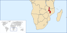
Malawi is a landlocked country in southeast Africa. It is wholly within the tropics; from about 9°30S at its northernmost point to about 17°S at the southernmost tip. The country occupies a thin strip of land between Zambia and Mozambique, extending southwards into Mozambique along the valley of the Shire River. In the north and north east it also shares a border with Tanzania. Malawi is connected by rail to the Mozambican ports of Nacala and Beira. It lies between latitudes 9° and 18°S, and longitudes 32° and 36°E.
The Great Rift Valley runs through the country from north to south. Lake Malawi lies within the rift valley, making up over three-quarters of Malawi's eastern boundary.[1] The Shire River flows down the rift valley from the south end of the lake to join the Zambezi River farther south in Mozambique.
Plateaus and mountains lie to the east and west of the Rift Valley. The Nyika Plateau lies west of Lake Malawi in the north of the country. The Shire Highlands lie in southern Malawi, east of the rift valley and Shire River and south of Lake Malawi. The Zomba and Mulanje mountain peaks rise from the highlands to respective heights of 2,100 and 3,000 metres (7,000 and 10,000 feet).[1]
Malawi has two sites listed on the UNESCO World Heritage List. Lake Malawi National Park was first listed in 1984 and the Chongoni Rock Art Area was listed in 2006.[2] Malawi's climate is hot in the low-lying areas in the south of the country and temperate in the northern highlands.
Geography[]
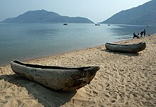
The Great Rift Valley traverses the country from north to south. In this deep trough lies Lake Malawi (also called Lake Nyasa), the third-largest lake in Africa, comprising about 25% of Malawi's area. Lake Malawi is sometimes called the Calendar Lake as it is about 587 km (365 mi) long and 84 km (52 mi) wide.[3] The surface of Lake Malawi is located at 460 m (1,500 ft) above sea level, with a maximum depth of 700 m (2,300 ft), which means the lake bottom is over 210 m (700 ft) below sea level at some points. The Shire River flows from the south end of the lake and joins the Zambezi River 400 km (250 mi) south in Mozambique.
West of the Great Rift Valley, the land forms high plateaus, plateaus rise generally 910 to 1,220 m (3,000 to 4,000 ft) above sea level. In the north, the Nyika Uplands rise as high as 2,400 m (8,000 ft). The area to the west of the lake in northern and central Malawi has been categorised by the World Wildlife Fund as part of the Central Zambezian miombo woodlands ecoregion.
South of the lake lie the Shire Highlands, with an elevation of 600–1,600 m (2,000–5,200 ft), rising to elevations of 2,130 and 3,002 m (6,988 and 9,849 ft) at the Zomba Plateau and Mulanje Massif respectively. The Kirk Range lies west of the Shire, and forms the border with Mozambique. In its middle stretch between and Chikwawa, the Shire River drops almost 400 m (1,300 ft) through 80 km (50 mi) of gorges, rapids, and cataracts. In the extreme south, the Shire enters the Zambezi lowlands, and the elevation is only 60–90 m (200–300 ft) above sea level.
Malawi has five national parks:
- Cape Maclear National Park
- Kasungu National Park
- Lengwe National Park
- Liwonde National Park
- Nyika National Park
Climate[]
Malawi's climate is generally tropical. The altitude moderates what would be an otherwise equatorial climate. Between November and April the temperature is warm with equatorial rains and thunderstorms, with the storms reaching their peak severity in late March. After March, the rainfall rapidly diminishes and from May to September wet mists float from the highlands into the plateaus, with almost no rainfall during these months.[1]
It is hot and humid from September to April along the lake and in the lower Shire Valley, with average daytime maximum around 27 to 29 °C (80.6 to 84.2 °F). Lilongwe is also hot and humid during these months, albeit far less than in the south. The rest of the country is warm during those months with a maximum temperature during the day around 25 °C (77 °F). From June through August, the lake areas and south are comfortably warm, with daytime maxima of around 23 °C (73.4 °F), but the rest of Malawi can be chilly at night, with temperatures ranging from 10–14 °C (50.0–57.2 °F). High altitude areas such as Mulanje and Nyika are often cold at night (around 6–8 °C or 42.8–46.4 °F) during June and July.
Karonga in the far north shows little variation in temperature with maximum daytime temperature remaining around 25 to 26 °C (77.0 to 78.8 °F) all year round but is unusual in that April and May are the wettest times of the year due to strengthening southerly winds along the lake.
Area[]
The total area of the country is 118,484 km2 (45,747 sq mi), but this includes 24,404 km2 (9,422 sq mi) of water surface, mainly composed of Lake Malawi, but there are other sizeable lakes, such as Lake Malombe, Lake Chilwa and Lake Chiuta. The land area is 94,080 km².
The country is dominated by Lake Malawi, which drains into the Zambezi River through the Shire River. As a result, the whole of the country, except for one eastern district is part of the Zambezi drainage system. Lake Chiuta and the surrounding plain is drained by the Lugenda river, which is part of the Ruvuma River drainage system. Lake Chilwa, about 35 km (22 mi) south of Lake Chiuta is unusual as it has no outlet although when it overflows it flows into Lake Chiuta through a swampy plain. High rates of evaporation ensure that the lake seldom fills up – much of the lake is only 1 metre deep or less.
Environment — current issues: Deforestation; land degradation; water pollution from agricultural runoff, sewage, industrial wastes; siltation of spawning grounds endangers fish populations
Environment — international agreements:
party to:
Biodiversity, Climate Change, Climate Change-Kyoto Protocol, Desertification, Endangered Species, Environmental Modification, Hazardous Wastes, Marine Life Conservation, Ozone Layer Protection, Ship Pollution, Wetlands
signed, but not ratified:
Law of the Sea[4]
Extreme points[]
This is a list of the extreme points of Ma, the points that are farther north, south, east or west than any other location.
- Northernmost point - the tripoint with Tanzania and Zambia, Northern Region
- Easternmost point - unnamed location on the border with Mozambique immediately south-west of the Mozambican village of , Southern Region
- Southernmost point - unnamed location on the border with Mozambique immediately north-east of the Mozambican village of , Southern Region
- Westernmost point - unnamed location on the border with Zambia, immediately east of the Zambian town of Chipata, Central Region
See also[]
References[]
- ^ a b c Cutter, Africa 2006, p. 142
- ^ Turner, The Statesman's Yearbook, p. 824
- ^ Douglas, John (Summer 1998). "Malawi: The Lake of Stars". Travel Africa (4). Archived from the original on 14 January 2009. Retrieved 22 August 2008.
- ^ "Africa :: Malawi — The World Factbook - Central Intelligence Agency". www.cia.gov. Retrieved 2019-04-08.
![]() This article incorporates public domain material from the CIA World Factbook website https://www.cia.gov/the-world-factbook/.
This article incorporates public domain material from the CIA World Factbook website https://www.cia.gov/the-world-factbook/.
- Geography of Malawi