Getahovit
Coordinates: 40°53′45″N 45°07′53″E / 40.89583°N 45.13139°E

Getahovit
Գետահովիտ | |
|---|---|
 Mijnashen Church near Getahovit | |
 Getahovit | |
| Coordinates: 40°53′45″N 45°07′53″E / 40.89583°N 45.13139°E | |
| Country | |
| Province | Tavush |
| Elevation | 835 m (2,740 ft) |
| Population | |
| • Total | 2,123 |
| Time zone | UTC+4 (AMT) |
| Getahovit at GEOnet Names Server | |
Getahovit (Armenian: Գետահովիտ) is a village in the Tavush Province of Armenia.
Toponymy[]
The village is also known as Tala and Talakand.
References[]
External links[]
| Wikimedia Commons has media related to Cultural heritage monuments in Getahovit, Tavush. |
- World Gazeteer: Armenia[dead link] – World-Gazetteer.com
- Report of the results of the 2001 Armenian Census, Statistical Committee of Armenia
| hide | ||
|---|---|---|
Capital: Ijevan | ||
| Urban communities | 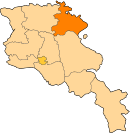 | |
| Rural communities |
| |
| Non-community settlements | ||
| Abandoned settlements | ||
| show Authority control |
|---|
This article about a location in Tavush Province, Armenia is a stub. You can help Wikipedia by . |
Categories:
- Populated places in Tavush Province
- Tavush geography stubs