Berd
This article relies largely or entirely on a single source. (November 2021) |
Coordinates: 40°52′51″N 45°23′30″E / 40.88083°N 45.39167°E

Berd
Բերդ | |
|---|---|
 A view of Berd | |
 Berd | |
| Coordinates: 40°52′51″N 45°23′30″E / 40.88083°N 45.39167°E | |
| Country | |
| Province | Tavush |
| Founded | 10th century |
| Area | |
| • Total | 3.5 km2 (1.4 sq mi) |
| Population | |
| • Total | 7,957 |
| • Density | 2,300/km2 (5,900/sq mi) |
| Time zone | UTC+4 (AMT) |
| Berd at GEOnet Names Server | |
Berd (Armenian: Բերդ) is a town and urban municipal community in the Tavush Province of Armenia. The town is located to the west of the Tavush river, 211 kilometres (131 miles) from Yerevan, surrounded by low mountains. Near the city are the ruins of the Tavush fortress (10th century) and the Nor Varagavank and Khoranashat monasteries (12th century). Other monasteries nearby include Shkhmuradi, Srveghi, and Kaptavank.
Etymology[]
Berd means "fortress" in Armenian. The town was formerly known as Berdagyugh, Gamma', Tavuzghala, Tauzkend, Volorut, Shlorut and Ghalakyand.
History[]

Historically, the area of modern-day Berd was part of the Tuchkatak canton of Utik, the 12th province of Greater Armenia.
Demographics[]
As of the 2011 census, the population of the town is 7,957.
The population are mainly Armenians. However the town is home to around 200 Udis, who also belong to the Armenian Apostolic Church.
Economy[]
Berd and the surrounding areas are a major centre for agricultural products in Armenia. Fruits, tobacco and other types are produced in the surrounding farms. Other notable industries of Berd include wine-making, bee-keeping and animal husbandry.
Gallery[]

Tavush fortress

Mariam Mayr Vank near Berd
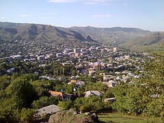
A view of Berd
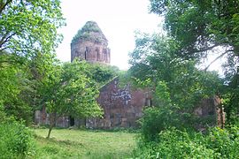
Khoranashat Monastery near Berd
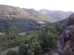
Scenery around Berd
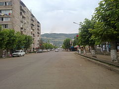
Mashtots Avenue


References[]
| Wikimedia Commons has media related to Berd city. |
| Wikivoyage has a travel guide for Berd. |
Capital: Ijevan | ||
| Urban communities | 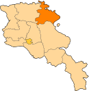 | |
| Rural communities |
| |
| Non-community settlements | ||
| Abandoned settlements | ||
| Aragatsotn |   | |
|---|---|---|
| Ararat | ||
| Armavir | ||
| Gegharkunik | ||
| Kotayk | ||
| Lori | ||
| Shirak | ||
| Syunik | ||
| Tavush |
| |
| Vayots Dzor | ||
| Capital city | ||
This article about a location in Tavush Province, Armenia is a stub. You can help Wikipedia by . |
- Populated places in Tavush Province
- Populated places established in the 10th century
- Elisabethpol Governorate
- Tavush geography stubs