Chambarak
Coordinates: 40°35′43″N 45°20′51″E / 40.59528°N 45.34750°E

Chambarak
Ճամբարակ | |
|---|---|
 | |
 Chambarak | |
| Coordinates: 40°35′43″N 45°20′51″E / 40.59528°N 45.34750°E | |
| Country | |
| Province | Gegharkunik |
| Founded | 1830s |
| Area | |
| • Total | 6 km2 (2 sq mi) |
| Population | |
| • Total | 5,850 |
| • Density | 980/km2 (2,500/sq mi) |
| Time zone | UTC+4 (AMT) |
| Chambarak at GEOnet Names Server | |
Chambarak (Armenian: Ճամբարակ) is a town and urban municipal community in the Gegharkunik Province of Armenia. As per the 2011 census, the population of the town was 5,850.[1]
Chambarak was founded in 1835-40 as Mikhaylovka on the Getik River by Russian immigrants. Karmir Gyugh and Krasnosyelsk both mean "Red Village" in Armenian and Russian respectively. The town was known as Mikhaylovka until 1920, Karmir Gyugh between 1920 and 1971, and Krasnoselsk between 1972 and 1991.
Etymology[]

The word Chambarak literally means small camp in Armenian. The names is derived from an older settlement that existed on the present town's place during the Middle Ages, as there are the remains of the 1st-century St. Grigor Church and many khachkars (cross-stones) in the town dating back to the 13th century.
History[]
Originally, the village of Mikhaylovka was gradually formed between 1740 and 1785 by Russian Molokan migrants who moved from the areas of Samara and Saratov of the Russian Empire. The village occupied the place of the older Armenian settlement of Chambarak. With the sovietization of Armenia in 1920, Mikhaylovka was renamed Karmir Gyugh (Red Village). In December 1937, the Krasnoselsk Raion was formed as an administrative division of the Armenian Soviet Socialist Republic, with the village of Karmir Gyugh as its centre.
In 1971, Karmir Gyugh was enlarged with the merger of the nearby settlements of Verin (upper) and Nerkin (lower) Chambarak, and turned into an urban-type settlement. The following year, the settlement was officially renamed Krasnoselsk.
As the USSR imploded, so the majority of Krasnoselsk's Molokan-Russian population left to return to Russia. Many of their vacated homes were given to IDPs from Artsvashen, an Armenian exclave within Azerbaijan which had been captured by Azerbaijani forces on August 8, 1992.[2] The same year, after the independence of Armenia, Krasnoselsk was renamed Chambarak and became an urban community (municipality).
In 2009, former residents of Artsvashen village, still resident in Chambarak, were promised six billion drams of Armenian government compensation for their lost property. Two payments of 50 million drams then, in 2011, a bigger one of 708 million drams was given out in 2011, with around 2000 people getting about 360 thousand drams each. However, further payments stalled leading to protests in September 2018 and December 2019, demanding further funds to repair the dilapidated housing stock in Chambarak. Armenian premier Pashinyan claimed that the state had fulfilled all its obligations to refugees with moneys already disbursed and with the provision of housing certificates to about 112 families.[3]
In July 2020, Chambarak became a site for clashes with Azerbaijan.[4]
Economy[]
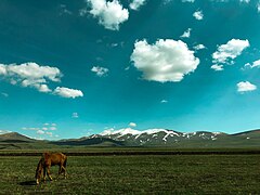
The population of Chambarak is mainly involved in agriculture and cattle-breeding. It used to have small firms for cheese production. However, in an interview in 2011, ArmeniaNow correspondent Gayane Mkrtchyan interviewed the mayor who said "Agriculture isn't profitable here because the soil is arid, and businesses don't invest because the region is considered to be at risk. It's termed a border zone, but it doesn't get specific privileges".[5]
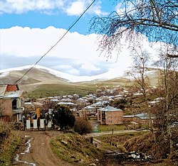
Gallery[]
Scenery

Beekeeping in the town
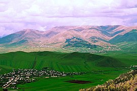
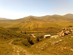
Chambarak landscape
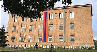
Municipal building in Chambarak

Khndzorkut mountain
Scenery


References[]
| Wikimedia Commons has media related to Chambarak. |
- ^ a b Statistical Committee of Armenia. "2011 Armenia census, Gegharkunik Province" (PDF).
- ^ ArmInfo report 2019
- ^ Naira Badalian's 2019 article on protests
- ^ Harutyunyan, Sargis; Danielyan, Emil. "Armenia-Azerbaijan Border 'Calm' After Deadly Clashes". azatutyun.am. RFE/RL. Archived from the original on 5 August 2020. Retrieved 5 August 2020.
...the border between Armenia’s northern Tavush province and the Tovuz district in Azerbaijan, the scene of the clashes.
- ^ REF-World article 2011

| Aragatsotn |   | |
|---|---|---|
| Ararat | ||
| Armavir | ||
| Gegharkunik | ||
| Kotayk | ||
| Lori | ||
| Shirak | ||
| Syunik | ||
| Tavush |
| |
| Vayots Dzor | ||
| Capital city | ||
This article about a location in Gegharkunik Province, Armenia is a stub. You can help Wikipedia by . |
- Populated places in Gegharkunik Province
- Populated places established in the 1830s
- Elisabethpol Governorate
- Gegharkunik geography stubs