Astghadzor
Astghadzor
Աստղաձոր | |
|---|---|
 St. Poghos-Petros Church in Astghadzor | |
 Astghadzor | |
| Coordinates: 40°07′26″N 45°21′24″E / 40.12389°N 45.35667°ECoordinates: 40°07′26″N 45°21′24″E / 40.12389°N 45.35667°E | |
| Country | |
| Province | Gegharkunik |
| Elevation | 2,025 m (6,644 ft) |
| Population | |
| • Total | 4,215 |
| Time zone | UTC+4 (AMT) |
| Postal code | 1403 |
| Astghadzor at GEOnet Names Server | |

Astghadzor (Armenian: Աստղաձոր) is a village in the Gegharkunik Province of Armenia.[2]
Toponymy[]
The village was previously known as Kats and Katsik, and until 1935, Alikrykh and Alighrkh.
Gallery[]
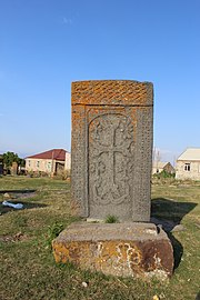
Khachkar in Astghadzor

References[]
- ^ Statistical Committee of Armenia. "The results of the 2011 Population Census of the Republic of Armenia" (PDF).
- ^ Kiesling, Brady; Kojian, Raffi (2005). Rediscovering Armenia: Guide (2nd ed.). Yerevan: Matit Graphic Design Studio. p. 80. ISBN 99941-0-121-8.
External links[]
| Wikimedia Commons has media related to Astghadzor. |
- World Gazeteer: Armenia[dead link] – World-Gazetteer.com
- Report of the results of the 2001 Armenian Census, Statistical Committee of Armenia
- Brady Kiesling, Rediscovering Armenia, p. 46; original archived at Archive.org, and current version online on Armeniapedia.org.

This article about a location in Gegharkunik Province, Armenia is a stub. You can help Wikipedia by . |
Categories:
- Populated places in Gegharkunik Province
- Gegharkunik geography stubs