Mets Masrik
Coordinates: 40°13′07″N 45°46′10″E / 40.21861°N 45.76944°E
Mets Masrik
Մեծ Մասրիկ | |
|---|---|
 Church in Mets Masrik | |
 Mets Masrik | |
| Coordinates: 40°13′07″N 45°46′10″E / 40.21861°N 45.76944°E | |
| Country | |
| Province | Gegharkunik |
| Area | |
| • Total | 2.8 km2 (1.1 sq mi) |
| Population (2019)[citation needed] | |
| • Total | 2,699 |
| Time zone | UTC+4 (AMT) |
| Mets Masrik at GEOnet Names Server | |
Mets Masrik (Armenian: Մեծ Մասրիկ, lit. 'big Masrik', historically Masrik) is a village in the Gegharkunik Province of Armenia. The village is located close to Pokr Masrik (lit. 'little Masrik').[1]
History[]
The town has been inhabited since the 7th century and has a khachkar dated 881, two shrines from the 12th and 13th centuries, and a 17th-century church.[1]
Demographics[]
Population[]
The village had 3,132 inhabitants in 2011.[2]
Gallery[]

House of Culture

Church in Mets Masrik

Khachkars in Mets Masrik

WWII monument

Khachkars in Mets Masrik

Church in Mets Masrik
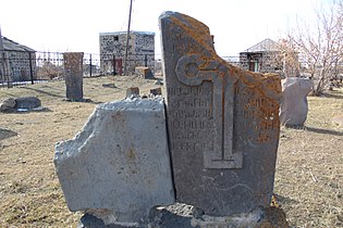
Khachkars in Mets Masrik


References[]
- ^ a b Kiesling, Brady; Kojian, Raffi (2005). Rediscovering Armenia: Guide (2nd ed.). Yerevan: Matit Graphic Design Studio. p. 82. ISBN 99941-0-121-8.
- ^ Statistical Committee of Armenia. "The results of the 2011 Population Census of the Republic of Armenia" (PDF).
External links[]
| Wikimedia Commons has media related to Cultural heritage monuments in Mets Masrik, Gegharkunik. |
- World Gazeteer: Armenia[dead link] – World-Gazetteer.com
- Report of the results of the 2001 Armenian Census, Statistical Committee of Armenia
- Brady Kiesling, Rediscovering Armenia, p. 48; original archived at Archive.org, and current version online on Armeniapedia.org.

This article about a location in Gegharkunik Province, Armenia is a stub. You can help Wikipedia by . |
Categories:
- Populated places in Gegharkunik Province
- Gegharkunik geography stubs