Yeranos
Yeranos
Երանոս | |
|---|---|
 Village entrance | |
 Yeranos | |
| Coordinates: 40°12′15″N 45°11′18″E / 40.20417°N 45.18833°ECoordinates: 40°12′15″N 45°11′18″E / 40.20417°N 45.18833°E | |
| Country | |
| Province | Gegharkunik |
| Elevation | 2,007 m (6,585 ft) |
| Population | |
| • Total | 5,479 |
| Time zone | UTC+4 (AMT) |
| Postal code | 1406 |
| Yeranos at GEOnet Names Server | |

Yeranos (Armenian: Երանոս) is a village in the Gegharkunik Province of Armenia.
History[]
The church of St. Astvatsatsin in the village dates back to 1215, and the village also contains Tukh Manuk and St. Sofia shrines. Following the Gavar-Martuni road, near the chicken farm, are the remains of a cyclopean fort.[2]
Gallery[]

Chapel in Yeranos

St. Astvatsatsin Church in Yeranos
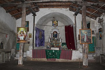
St. Astvatsatsin Church interior


References[]
- ^ Statistical Committee of Armenia. "The results of the 2011 Population Census of the Republic of Armenia" (PDF).
- ^ Kiesling, Brady; Kojian, Raffi (2005). Rediscovering Armenia: Guide (2nd ed.). Yerevan: Matit Graphic Design Studio. pp. 78–79. ISBN 99941-0-121-8.
External links[]
| Wikimedia Commons has media related to Yeranos, Gegharkunik. |
- World Gazeteer: Armenia[dead link] – World-Gazetteer.com
- Report of the results of the 2001 Armenian Census, Statistical Committee of Armenia
- Brady Kiesling, Rediscovering Armenia, p. 45; original archived at Archive.org, and current version online on Armeniapedia.org.

This article about a location in Gegharkunik Province, Armenia is a stub. You can help Wikipedia by . |
Categories:
- Populated places in Gegharkunik Province
- Gegharkunik geography stubs