Khachaghbyur
Coordinates: 40°10′20″N 45°41′19″E / 40.17222°N 45.68861°E

Khachaghbyur
Խաչաղբյուր | |
|---|---|
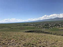 A view of Khachaghbyur from Murad Khach | |
 Khachaghbyur | |
| Coordinates: 40°10′20″N 45°41′19″E / 40.17222°N 45.68861°E | |
| Country | |
| Province | Gegharkunik |
| Population | |
| • Total | 1,064 |
| Time zone | UTC+4 (AMT) |
| Khachaghbyur at GEOnet Names Server | |
Khachaghbyur (Armenian: Խաչաղբյուր) is a village in the Gegharkunik Province of Armenia. The village is located immediately to the south of the Lusakunk village and to the west of Vardenis.
Toponymy[]
The village was previously known as Chakhyrlu, Chakhrlu, Chakhirlu, Sovietakert and Sovetakert.
History[]
Near the village is a ruined Iron Age fort, Murad Khach, as well as a 13th-century church.[2]
Gallery[]
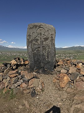
Khachkar on Murad Khach

Murad Khach


References[]
- ^ Statistical Committee of Armenia. "The results of the 2011 Population Census of the Republic of Armenia" (PDF).
- ^ Kiesling, Brady; Kojian, Raffi (2005). Rediscovering Armenia: Guide (2nd ed.). Yerevan: Matit Graphic Design Studio. p. 81. ISBN 99941-0-121-8.
External links[]
| Wikimedia Commons has media related to Khachaghbyur. |
- World Gazeteer: Armenia[dead link] – World-Gazetteer.com
- Report of the results of the 2001 Armenian Census, Statistical Committee of Armenia
- Brady Kiesling, Rediscovering Armenia, p. 47; original archived at Archive.org, and current version online on Armeniapedia.org.

This article about a location in Gegharkunik Province, Armenia is a stub. You can help Wikipedia by . |
Categories:
- Populated places in Gegharkunik Province
- Gegharkunik geography stubs