Madina, Armenia
Coordinates: 40°04′49″N 45°15′04″E / 40.08028°N 45.25111°E

Madina
Մադինա | |
|---|---|
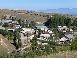 A view of Madina | |
 Madina | |
| Coordinates: 40°04′49″N 45°15′04″E / 40.08028°N 45.25111°E | |
| Country | |
| Province | Gegharkunik |
| Population | |
| • Total | 1,111 |
| Time zone | UTC+4 (AMT) |
| Madina, Armenia at GEOnet Names Server | |
Madina (Armenian: Մադինա) is a village in the Gegharkunik Province of Armenia. To the west of Madina is Mount Armaghan, an extinct volcano that rises 450 meters higher than the surrounding plain with a small crater lake at its center.[2]
History[]
According to the Russian statistical source Sbornik svedenij o Kavkaze, the village of Madina had as of 1873 a population of 208 people, all of them Azeris.[3] By 1911, the population had risen to 443 people.[4]
Gallery[]

Chapel on Mount Armaghan
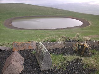
On top of Mount Armaghan

Cemetery on top of Mount Armaghan


References[]
- ^ Statistical Committee of Armenia. "The results of the 2011 Population Census of the Republic of Armenia" (PDF).
- ^ Kiesling, Brady; Kojian, Raffi (2005). Rediscovering Armenia: Guide (2nd ed.). Yerevan: Matit Graphic Design Studio. p. 79. ISBN 99941-0-121-8.
- ^ Сборник сведений о Кавказе. V. Тф. 1880. p. 107.
- ^ Кавказский календарь. Тф. 1912. p. 180.
External links[]
| Wikimedia Commons has media related to Madina, Armenia. |
- World Gazeteer: Armenia[dead link] – World-Gazetteer.com
- Report of the results of the 2001 Armenian Census, Statistical Committee of Armenia
- Brady Kiesling, Rediscovering Armenia, p. 45; original archived at Archive.org, and current version online on Armeniapedia.org.

This article about a location in Gegharkunik Province, Armenia is a stub. You can help Wikipedia by . |
Categories:
- Populated places in Gegharkunik Province
- Populated places established in 1922
- Cities and towns built in the Soviet Union
- 1922 establishments in the Soviet Union
- Gegharkunik geography stubs