Dzoravank
Dzoravank
Ձորավանք | |
|---|---|
 Church in Dzoravank | |
 Dzoravank | |
| Coordinates: 40°41′54″N 45°06′25″E / 40.69833°N 45.10694°ECoordinates: 40°41′54″N 45°06′25″E / 40.69833°N 45.10694°E | |
| Country | |
| Province | Gegharkunik |
| Elevation | 1,164 m (3,819 ft) |
| Population | |
| • Total | 176 |
| Time zone | UTC+4 (AMT) |
| Postal code | 1314 |
| Dzoravank at GEOnet Names Server | |

Dzoravank (Armenian: Ձորավանք; Azerbaijani: Qaraqaya, anglicized: Garagaya) is a village in the Gegharkunik Province of Armenia.[2] The village was populated by Azerbaijanis before the exodus of Azerbaijanis from Armenia after the outbreak of the Nagorno-Karabakh conflict. In 1988-1989 Armenian refugees from Azerbaijan settled in the village.[3]
Gallery[]

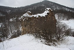
Scenery around Dzoravank Church in winter

References[]
- ^ Statistical Committee of Armenia. "The results of the 2011 Population Census of the Republic of Armenia" (PDF).
- ^ Kiesling, Brady; Kojian, Raffi (2005). Rediscovering Armenia: Guide (2nd ed.). Yerevan: Matit Graphic Design Studio. p. 85. ISBN 99941-0-121-8.
- ^ "ՁՈՐԱՎԱՆՔ". gegharkunik.am. Retrieved 14 February 2021.
External links[]
| Wikimedia Commons has media related to Cultural heritage monuments in Dzoravank, Gegharkunik. |
- Report of the results of the 2001 Armenian Census, Statistical Committee of Armenia
- Brady Kiesling, Rediscovering Armenia, p. 50; original archived at Archive.org, and current version online on Armeniapedia.org.

This article about a location in Gegharkunik Province, Armenia is a stub. You can help Wikipedia by . |
Categories:
- Populated places in Gegharkunik Province
- Gegharkunik geography stubs