Ddmashen
Ddmashen
Դդմաշեն | |
|---|---|
 View of Ddmashen along the road from neighboring Zovaber. The Church of St. Thaddeus the Apostle can be seen to the right. | |
 Ddmashen | |
| Coordinates: 40°34′14″N 44°49′06″E / 40.57056°N 44.81833°ECoordinates: 40°34′14″N 44°49′06″E / 40.57056°N 44.81833°E | |
| Country | |
| Province | Gegharkunik |
| Founded | 1828 |
| Area | |
| • Total | 1.86 km2 (0.72 sq mi) |
| Elevation | 1,798 m (5,899 ft) |
| Population | |
| • Total | 2,806 |
| • Density | 1,500/km2 (3,900/sq mi) |
| Time zone | UTC+4 (AMT) |
| Postal code | 1508 |
| Ddmashen at GEOnet Names Server | |

Ddmashen (Armenian: Դդմաշեն) is a village in the Gegharkunik Province of Armenia.
Toponymy[]
The village is also known as Totmashen and Dodmashen.
History[]
The village was founded in 1828 by emigrants from Maku. The 7th-century St. Thaddeus the Apostle Church is located in the eastern part of the village.[2][3]
Gallery[]
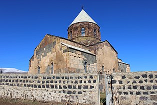
St. Thaddeus the Apostle Church in Ddmashen

View of Ddmashen along the road from neighboring Zovaber

Tsarav Dzor Chapel in Ddmashen

World War II monument

Cemetery in Ddmashen


References[]
- ^ Statistical Committee of Armenia. "The results of the 2011 Population Census of the Republic of Armenia" (PDF).
- ^ Kiesling, Brady; Kojian, Raffi (2005). Rediscovering Armenia: Guide (2nd ed.). Yerevan: Matit Graphic Design Studio. p. 75. ISBN 99941-0-121-8.
- ^ Holding, Deirdre (2014). Armenia: with Nagorno Karabagh (Bradt Travel Guides) (4th ed.). Guilford, Conn.: The Globe Pequot Press Inc. p. 202. ISBN 978-1-84162-555-3.
External links[]
| Wikimedia Commons has media related to Ddmashen. |
- World Gazeteer: Armenia[dead link] – World-Gazetteer.com
- Report of the results of the 2001 Armenian Census, Statistical Committee of Armenia
- Brady Kiesling, Rediscovering Armenia, p. 41; original archived at Archive.org, and current version online on Armeniapedia.org.
- DDMASHEN (Gegharkunik) - Union of Communities of Armenia

Categories:
- Populated places in Gegharkunik Province
- Populated places established in 1828