Glen Ewen
Glen Ewen | |
|---|---|
Village | |
| Village of Glen Ewen | |
 Downtown Glen Ewen | |
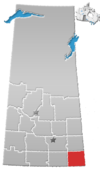
 Location of Glen Ewen in Saskatchewan  Glen Ewen (Canada) | |
| Coordinates: 49°12′23″N 102°01′10″W / 49.2063°N 102.0195°W | |
| Country | |
| Province | |
| Region | Southeast |
| Census division | 1 |
| Rural Municipality | Enniskillen No. 3 |
| Post office Founded | 1890-11-01 |
| Government | |
| • Type | Municipal |
| • Governing body | Glen Ewen Village Council |
| • Mayor | Glen Lewis |
| • Administrator | Myrna-Jean Babbings |
| • MP | Robert Kitchen |
| • MLA | Dan D'Autremont |
| Area | |
| • Total | 2.77 km2 (1.07 sq mi) |
| Population (2016) | |
| • Total | 154 |
| • Density | 55.6/km2 (144/sq mi) |
| Time zone | UTC-6 (CST) |
| Postal code | S0C 1C0 |
| Area code(s) | 306 |
| Highways | |
| Railways | Canadian Pacific Railway |
| Website | Village of Glen Ewen |
| [1][2][3][4] | |
Glen Ewen (2016 population: 154) is a village in the Canadian province of Saskatchewan within the Rural Municipality of Enniskillen No. 3 and Census Division No. 1. The village is located on the Canadian Pacific Railway just south of Provincial Highway 18. The towns of Carnduff and Oxbow are nearby.
The community was founded March 24, 1905 by a rail worker and Glen Ewen's first postmaster (Thomas Ewen). The town policy of tearing down any dwellings which have been vacated, combined with the current boom in the oilfield in this area, has resulted in a housing shortage for incoming workers. The school was closed in November, 1989, and now is the Glen Ewen Communiplex.
In 2011 the new Glen Ewen Hotel was opened, replacing the old hotel that had burned down in 2007.[5]
History[]
Glen Ewen incorporated as a village on March 24, 1904.[6]
In 1959, the now defunct Glen Ewen Eagles were among the four founding teams of the men's senior Big 6 Hockey League. They never won a championship.[7]
Demographics[]
In the 2016 Census of Population conducted by Statistics Canada, the Village of Glen Ewen recorded a population of 154 living in 69 of its 78 total private dwellings, a 6.5% change from its 2011 population of 144. With a land area of 2.77 km2 (1.07 sq mi), it had a population density of 55.6/km2 (144.0/sq mi) in 2016.[10]
In the 2011 Census of Population, the Village of Glen Ewen recorded a population of 144, a 20% change from its 2006 population of 120. With a land area of 2.77 km2 (1.07 sq mi), it had a population density of 52.0/km2 (134.6/sq mi) in 2011.[11]
See also[]
- List of communities in Saskatchewan
- Villages of Saskatchewan
References[]
- ^ National Archives, Archivia Net, Post Offices and Postmasters, archived from the original on 6 October 2006
- ^ "Archived copy". Archived from the original on 21 November 2008. Retrieved 26 May 2007.CS1 maint: archived copy as title (link) CS1 maint: unfit URL (link)
- ^ Canadian Textiles Institute (2005), CTI Determine your provincial constituency, archived from the original on 11 September 2007
- ^ Commissioner of Canada Elections, Chief Electoral Officer of Canada (2005), Elections Canada On-line
- ^ "FEBRUARY 4, 2011 - Saskatchewan Economic News - Glen Ewen - Sourced from the Oxbow Herald, January 24, 2011". Enterprise Saskatchewan. Archived from the original on 25 February 2011. Retrieved 17 February 2011.
- ^ "Urban Municipality Incorporations". Saskatchewan Ministry of Government Relations. Archived from the original on 15 October 2014. Retrieved 1 June 2020.
- ^ https://www.bigsixhockey.com/
- ^ "Saskatchewan Census Population" (PDF). Saskatchewan Bureau of Statistics. Archived from the original (PDF) on 24 September 2015. Retrieved 31 May 2020.
- ^ "Saskatchewan Census Population". Saskatchewan Bureau of Statistics. Retrieved 31 May 2020.
- ^ "Population and dwelling counts, for Canada, provinces and territories, and census subdivisions (municipalities), 2016 and 2011 censuses – 100% data (Saskatchewan)". Statistics Canada. 8 February 2017. Retrieved 30 May 2020.
- ^ "Population and dwelling counts, for Canada, provinces and territories, and census subdivisions (municipalities), 2011 and 2006 censuses (Saskatchewan)". Statistics Canada. 3 June 2019. Retrieved 30 May 2020.
External links[]
Coordinates: 49°12′23″N 102°01′10″W / 49.2063°N 102.0195°W
- Villages in Saskatchewan
- Enniskillen No. 3, Saskatchewan
- Division No. 1, Saskatchewan
