Glen Oak, New South Wales
| Glen Oak New South Wales | |||||||||||||||
|---|---|---|---|---|---|---|---|---|---|---|---|---|---|---|---|
 Glen Oak School of Arts (1899) | |||||||||||||||
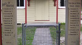 Detail of the Rolls of Honour at the entrance to the School of Arts hall | |||||||||||||||
 Glen Oak | |||||||||||||||
| Coordinates | 32°36.2′S 151°41.6′E / 32.6033°S 151.6933°ECoordinates: 32°36.2′S 151°41.6′E / 32.6033°S 151.6933°E | ||||||||||||||
| Population | 328 (2011 census)[2][Note 1] | ||||||||||||||
| • Density | 11.16/km2 (28.9/sq mi) [Note 1] | ||||||||||||||
| Postcode(s) | 2320 | ||||||||||||||
| Area | 45.1 km2 (17.4 sq mi)[Note 2] | ||||||||||||||
| Time zone | AEST (UTC+10) | ||||||||||||||
| • Summer (DST) | AEDT (UTC+11) | ||||||||||||||
| Location |
| ||||||||||||||
| LGA(s) |
| ||||||||||||||
| Region | Hunter[1] | ||||||||||||||
| County | Durham[5] | ||||||||||||||
| Parish | Uffington[5] | ||||||||||||||
| State electorate(s) | Port Stephens[6] | ||||||||||||||
| Federal Division(s) | Paterson[7] | ||||||||||||||
| |||||||||||||||
| |||||||||||||||

Glen Oak is a small community in the Hunter Region of New South Wales, Australia, shared between the Port Stephens and Dungog local government areas (LGA). Approximately two thirds of the suburb's 45.1 square kilometres (17.4 sq mi) is located within the Port Stephens LGA while the remaining third, which is sparsely populated, is located in Dungog Shire.[1][9][10]

Glen Oak was originally a small town, settled in the 19th century as a river port. During the late 19th and early 20th century the town included a community hall, post office, public school and general store. Declining river trade affected Glen Oak and by the 1950s much of the village itself had been abandoned. Today, very little is left to indicate that a town ever existed. However, the School of Arts hall on Clarence Town Road, built in 1899 and possibly[weasel words] the last community-owned hall in Australia,[citation needed] still stands and is used for various social activities. At the entrance to the hall are two pillars commemorating local men from the area who fought in World War I.
Only a handful of Glen Oak's original homesteads still exist, the oldest of which is Thomas Holmes' "Oakendale" (circa 1830, damaged by fire in 1909). There were also at least two homesteads overlooking the Williams River at "Langlands" between 1857 and 1970. The older of the two was destroyed by fire at about 2:30am on the morning of 20 June 1889.[11] The second homestead, built sometime before 1892, fell into disrepair after the Second World War and was demolished in the 1970s.
Notes[]
- ^ Jump up to: a b ABS Quickstats data only covers the 29.4 km2 (11.4 sq mi) of Glen Oak's 45.1 km2 (17.4 sq mi) that lies within the Port Stephens LGA. The population density shown is that for the area covered by ABS Quickstats, not for the entire suburb.[3] The remaining part of Glen Oak is included in the population data for Clarence Town.[4]
- ^ Area calculation is based on 1:100000 map 9232 NEWCASTLE.
References[]
- ^ Jump up to: a b c "Suburb Search – Local Council Boundaries – Hunter (HT) – Port Stephens". New South Wales Division of Local Government. Archived from the original on 21 June 2014. Retrieved 11 June 2008.
- ^ Australian Bureau of Statistics (31 October 2012). "Glen Oak (State Suburb)". 2011 Census QuickStats. Retrieved 6 July 2017.

- ^ Australian Bureau of Statistics (31 October 2012). "2011 Community Profiles: Glen Oak (State Suburb)". 2011 Census of Population and Housing. Retrieved 15 October 2012.
- ^ Australian Bureau of Statistics (31 October 2012). "Clarence Town (State Suburb)". 2011 Census QuickStats. Retrieved 15 October 2012.
- ^ Jump up to: a b "Glen Oak". Geographical Names Register (GNR) of NSW. Geographical Names Board of New South Wales. Retrieved 27 May 2008.
- ^ "Port Stephens". New South Wales Electoral Commission. Retrieved 23 November 2019.
- ^ "Paterson". Australian Electoral Commission. 19 October 2007. Archived from the original on 29 October 2009. Retrieved 11 June 2008.
- ^ Jump up to: a b c "Paterson (Tocal AWS)". Climate statistics for Australian locations. Bureau of Meteorology. Retrieved 6 June 2008.
- ^ "Suburb Search – Local Council Boundaries – Hunter (HT) – Dungog Shire Council". New South Wales Division of Local Government. Archived from the original on 28 July 2008. Retrieved 11 June 2008.
- ^ "Glen Oak". Land and Property Management Authority - Spatial Information eXchange. New South Wales Land and Property Information. Retrieved 27 May 2008.
- ^ "2 Jul 1889 – Fire at Langlands, near Seaham, Williams River". Trove. National Library of Australia. Retrieved 1 February 2012.
 Media related to Glen Oak, New South Wales at Wikimedia Commons
- Suburbs of Port Stephens Council
- Suburbs of Dungog Shire