Nelsons Plains, New South Wales
| Nelsons Plains New South Wales | |||||||||||||||
|---|---|---|---|---|---|---|---|---|---|---|---|---|---|---|---|
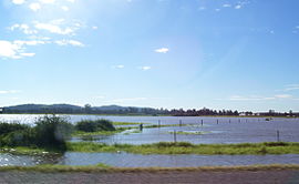 Flooding at Nelsons Plains in 2007 | |||||||||||||||
 Nelsons Plains | |||||||||||||||
| Coordinates | 32°42′54″S 151°43′04″E / 32.71500°S 151.71778°ECoordinates: 32°42′54″S 151°43′04″E / 32.71500°S 151.71778°E | ||||||||||||||
| Population | 362 (2016 census)[2] | ||||||||||||||
| • Density | 16.4/km2 (42/sq mi) | ||||||||||||||
| Postcode(s) | 2324 | ||||||||||||||
| Elevation | 2 m (7 ft)[Note 1] | ||||||||||||||
| Area | 19.8 km2 (7.6 sq mi)[Note 2] | ||||||||||||||
| Time zone | AEST (UTC+10) | ||||||||||||||
| • Summer (DST) | AEDT (UTC+11) | ||||||||||||||
| Location |
| ||||||||||||||
| LGA(s) | Port Stephens Council[1] | ||||||||||||||
| Region | Hunter[1] | ||||||||||||||
| County | Durham[3] | ||||||||||||||
| Parish | Seaham[3] | ||||||||||||||
| State electorate(s) | Port Stephens[4] | ||||||||||||||
| Federal division(s) | Paterson[5] | ||||||||||||||
| |||||||||||||||

Nelsons Plains is a primarily rural suburb of the Port Stephens local government area in the Hunter Region of New South Wales, Australia.[1][3] It is situated on Seaham Road between the Hunter and Williams rivers.[6] At the 2016 census the suburb had a population of 362.[2]
Geography[]
Nelsons Plains is a wedge-shaped suburb, bisected by Seaham Road, with the point of the wedge in the south-eastern corner where the Williams River joins the Hunter River.[6] This part of the suburb is generally less than 2 metres (7 ft) above river level, making it subject to periodic flooding, as happened during the June 2007 Hunter Region and Central Coast storms. In the north-eastern corner of the suburb elevations reach up to 42 m (138 ft) but to the east of Seaham Road, between the road and the Williams River, the ground slopes quickly downward to a height of less than 2 m (7 ft) above river level, making this part of the suburb also subject to flooding.
Demographics[]
At the 2016 census the population was 362, with a median age of 41 and 89.6% of the population spoke only English at home. Australian born residents represented 88.8%, with 2.0% born in New Zealand and 0.8% in England. For religion, 31.4% identified as Anglican, 28.3% as Catholic, 18.9% as having no religion, 7.5% did not state a religion and 5.8% belonging to the Uniting Church.[2]


Notes[]
References[]
- ^ a b c "Suburb Search – Local Council Boundaries – Hunter (HT) – Port Stephens". New South Wales Division of Local Government. Retrieved 29 June 2008.
- ^ a b c Australian Bureau of Statistics (27 June 2017). "Nelsons Plains (State Suburb)". 2016 Census QuickStats. Retrieved 16 October 2020.

- ^ a b c "Nelsons Plains". Geographical Names Register (GNR) of NSW. Geographical Names Board of New South Wales. Retrieved 29 June 2008.
- ^ "Port Stephens". New South Wales Electoral Commission. Retrieved 23 November 2019.
- ^ "Paterson". Australian Electoral Commission. 19 October 2007. Archived from the original on 29 October 2009. Retrieved 29 June 2008.
- ^ a b "Nelsons Plains". Land and Property Management Authority - Spatial Information eXchange. New South Wales Land and Property Information. Retrieved 29 June 2008.
![]() Media related to Nelsons Plains, New South Wales at Wikimedia Commons
Media related to Nelsons Plains, New South Wales at Wikimedia Commons
- Suburbs of Port Stephens Council