Greenland, Colorado
Greenland, Colorado | |
|---|---|
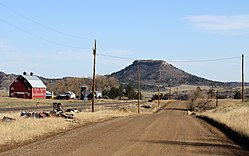
 East Noe Road in Greenland, with Larkspur Butte in the distance. | |
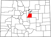
 Greenland Location in Douglas County and state of Colorado | |
| Coordinates: 39°10′57″N 104°51′19″W / 39.18250°N 104.85528°WCoordinates: 39°10′57″N 104°51′19″W / 39.18250°N 104.85528°W | |
| Country | |
| State | |
| County | Douglas County[1] |
| Government | |
| • Type | Unincorporated Community[1] |
| Area | |
| • Total | 1.3 sq mi (3.5 km2) |
| • Land | 1.3 sq mi (3.5 km2) |
| • Water | 0 sq mi (0 km2) |
| Elevation | 6,726 ft (2,050 m) |
| Time zone | UTC-7 (MST) |
| • Summer (DST) | UTC-6 (MDT) |
| ZIP code[3] | 80118 (Larkspur) |
| Area code(s) | 303 |
| FIPS code | 08-43550 |
| Primary Major Routes | |
| Secondary Major Routes | |
Greenland is an unincorporated community in Douglas County, Colorado, United States. Greenland is located off Exit 167 on Interstate 25. The largest nearby incorporated towns are Larkspur and Monument: Larkspur lies about 7 miles northeast and Monument about 13 miles south of the community. The U.S. Post Office at Larkspur (ZIP Code 80118) now serves the Greenland postal addresses.[3]
A post office called Greenland was established in 1873, and remained in operation until 1959.[4] The community was named for the green character of the original town site.[5]
Activities[]
A series of trail races of varying distances are held in Greenland each May.[6] Douglas County Division of Open Space and Natural Resources manages Spruce Meadows Open Space and Trail, which is located on the southern edge of Greenland.[7] Spruce Meadows Trail is a largely flat 8.6 mile-long path near Spruce Mountain that affords a view of Pikes Peak.[8]
Transportation[]
Roads[]
Greenland is Directly served by I-25, US-85 and US-87 via. exit 167 at Noe Rd. But it is also served by SH-105.
Rail[]
Colorado's Joint Line (owned by Union Pacific and BNSF) operates through Greenland. There are no passenger trains that operate in and out of Greenland, though.
See also[]
- Colorado municipalities
- Denver-Aurora Metropolitan Statistical Area
- Denver-Aurora-Boulder Combined Statistical Area
- Front Range Urban Corridor
References[]
- ^ a b "Active Colorado Municipalities". State of Colorado, Department of Local Affairs. Archived from the original on 2010-11-23. Retrieved 2007-09-01.
- ^ "US Board on Geographic Names". United States Geological Survey. 2007-10-25. Retrieved 2008-01-31.
- ^ a b "ZIP Code Lookup". United States Postal Service. December 27, 2006. Archived from the original (JavaScript/HTML) on November 23, 2010. Retrieved December 27, 2006.
- ^ "Post offices". Jim Forte Postal History. Retrieved 25 June 2016.
- ^ Dawson, John Frank. Place names in Colorado: why 700 communities were so named, 150 of Spanish or Indian origin. Denver, CO: The J. Frank Dawson Publishing Co. p. 25.
- ^ "Greenland Trail Races". Colorado Runner Events. Archived from the original on 14 July 2021. Retrieved 14 July 2021.
- ^ "Spruce Meadows Open Space and Trail". Castle Rock, CO: Douglas County Division of Open Space and Natural Resources. Archived from the original on 14 July 2021. Retrieved 14 July 2021.
- ^ "Spruce Meadows Open Space Trail". Castle Rock, CO: Douglas County Division of Open Space and Natural Resources. Archived from the original on 14 July 2021. Retrieved 14 July 2021.
External links[]
- Unincorporated communities in Douglas County, Colorado
- Unincorporated communities in Colorado
- Denver metropolitan area

