Gulbarga Fort
| Gulbarga Fort | |
|---|---|
| Part of Gulbarga | |
| Gulbarga, India | |
 Gulbarga Fort | |
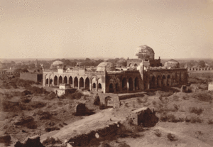 Great Mosque (Jami Masjid) in Gulbarga Fort | |
 Gulbarga Fort | |
| Coordinates | 17°20′26″N 76°49′52″E / 17.3405°N 76.8311°ECoordinates: 17°20′26″N 76°49′52″E / 17.3405°N 76.8311°E [1] |
| Type | Fort |
| Site information | |
| Controlled by | Government of Karnataka |
| Open to the public | Yes |
| Condition | Ruins |
| Site history | |
| Built | Fourteenth century |
| Built by | Sultan Al-ud-din Bahmani of Bahmani Sultanate in 1327 and Adil Shah |
| Materials | Granites and lime mortar |

The Gulbarga Fort is located in Gulbarga City in the Gulbarga district of North Karnataka. It was subsequently significantly enlarged in 1347 by Al-ud-din Hasan Bahmani of the Bahmani Dynasty after he cut off his ties with the Delhi Sultanate; Islamic monuments such as mosques, palaces, tombs, and other structures were also built later within the refurbished fort. The Jama Masjid built later, within the fort, in 1367, is a unique structure built in Persian architectural style, fully enclosed, with elegant domes and arched columns, which is unlike any other mosque in India. It was built to commemorate the establishment of the dynastic rule of the Bahmani kingdom at Gulbarga fort between 1327 and 1424. It remained the capital of the Bahmani Kingdom till 1424 where after the capital was shifted to Bidar Fort, as Bidar had better climatic conditions.[1][2][3]
History[]
The early history of the region dates back to the 6th century when the Rashtrakutas ruled over the external areas, except Gulbarga city. The Chalukyas won back their domain and ruled for over two hundred years. The Kalachuris of Kalyani succeeded them and ruled till the 12th century. At the end of the 12th century, it came under the reign of the Yadavas of Devagiri and the Hoysalas of Halebid. During this period, the Kakatiya dynasty, kings of Warangal were also powerful and took control of the present Gulbarga district and Raichur District.[4][5]
The Kakatiya power was subdued in 1321, and the northern Deccan, including the district of Gulbarga, passed under the control of the Sultanate of Delhi.[4][5]
In the early 14th century, the Deccan was occupied by Muhammad bin Tughluq of the Delhi Sultanate, which included Gulbarga. The revolt of the Muslim officers appointed from Delhi resulted in the founding of the Bahmani Sultanate in 1347 by Alauddin Hassan, who chose Gulbarga (named as 'Ahsenabad' during this period) to be his capital. Gulbarga was the capital of the Bahmani kingdom (1347–1527) (with headquarters at the Gulbarga fort), a newly founded independent state, until 1424 when the capital was transferred to Bidar. It is said that with the establishment of the Bahmani Kingdom, the Muslim rule took firm roots in the Deccan. Ahmad Shah Wali Bahmani had inducted immigrants from Iraq, Iran and Central Asia, which changed the social, cultural and religious life in the Deccan but was well amalgamated with Hindu traditions.[1][4][5][6][7]
The Gulbarga fort was razed to the ground by the Vijayanagar Emperor but was subsequently rebuilt by Yusuf Adil Shah (1459–1511), who established the Adil Shah dynasty or Bijapur Sultanate, when he defeated the Vijayanagar emperor. The Vijayanagara Empire was plundered and with this rich booty, the Gulbarga fort was refurbished.[citation needed]
World’s Longest Cannon at Bahmani Fort[]
The Bahmani Sultanate was a first independent Islamic state of the Deccan in South India and one of the great medieval Indian kingdoms. During the 191 years (1347-1538 A.D.) of Bahmani reign ruled with Gulbarga (Ahasnabad) and Bidar as their capital It was a great discovery for National award-winning artist and photographer Mohammed Ayazuddin Patel, Indo-Islamic Art of North Karnataka researcher Dr. Rehaman Patel and coin collector Mohammed Ismail that have found the World's longest canon in our own city.[citation needed]
It is exciting news for Gulbarga and Hyderabad Karnataka region people that the longest canon is located in Gulbarga fort installed during the reign of Bahmani Empire in the 14th century made by Turkish. It is made up of alloy (Panch dhatu).
It is the Bara Gazi toph (canon) which measures about 29 feet in length. The circumference is 7.6 feet, diameter 2 feet and thickness is 7 inch. The canon which claims to be the largest one in the world is just 23 feet long. This canon is located Koulas fort in Nizamabad district, Telangana.
The Asaf Jah-I (first Nizam) granted the Koulas fort to Rajput king Raja Kunwar Gopal Singh Gaur in 1724 AD for his bravery in the battle of Balapur and Shakkar Kheda.
The Archaeological Survey of India and State Archaeology should take immediate step to protect the Gulbarga fort canon and it should be included in the world record list. Fencing should be done around the canon for its safety. The canon is filled with mud and small stones which should be cleaned. Also, a signboard containing the details about the size of canon mentioning it as ‘the longest canon in the world is required.
The Bahmanis ruled over most of the Deccan until the late 15th and early 16th century, when the kingdom was divided into five independent states.[5][7][8][9]
The Mughal Emperor Aurangzeb (1658–1707) captured the fort in the 17th century (1687) and appointed Asaf Jah I ("Nizam-ul-Mulk") as the Governor of the Deccan. In the early part of the 18th century, when Mughal Empire was declining, the Nizam became independent in 1724, and formed the Hyderabad State, of which Gulbarga area was a part.[4][5][8]
The fort and the Gulbarga district were a part of Kingdom of Hyderabad under the Nizams rule. After India became independent in August 1947, Hyderabad state was annexed to the Indian union in 1948. In 1956, the Indian state of Hyderabad was partitioned among neighboring states along linguistic lines and renamed as Andhra Pradesh(now Telangana). Most of the Gulbarga district became part of the then Mysore state, later renamed Karnataka, excluding two taluks, which were given to Andhra Pradesh.[3]
Geography[]
It is located on a plateau land in the northeastern part of Karnataka. Krishna River and Bhima River drain the district. The soil formation in the region is predominantly of black cotton soil.[3][4][10]
Fort is in the drought prone district and experiences a meagre average rainfall of 777 millimetres (30.6 in) with only 46 normal rainy days.[4]
Climate is dry and cold in the winter but summer is hot. South west monsoon brings rains. Temperature during summer is a high of 45 °C (113 °F), the minimum recorded in winter is 5 °C (41 °F).[3][4][10]
Structures[]
With the establishment of the Bahmani Kingdom in the Deccan from 1347, the architectural styles of the Persian architecture of Iran made impressive and lasting impacts, which are seen in the Gulbarga Fort. The mosques, arches, gardens, and the palaces were built within and also outside the fort in the Gulbarga town.[clarification needed] Within the fort, the buildings built are impressive with Indo-Persian architecture that evolved in the Deccan. Professor Desai has observed:
A distinct Indo-Persian architectural style of Deccan came into existence after the establishment of the Bahmani dynasty in 1347.
Some of the important structures built are elaborated.[11]
Fort[]
The fort was originally built by first Sultan Alauddin Hasan Bahman Shah, the founder of Bahmani Empire.[5] It was subsequently substantially fortified in West Asian and European military architectural style by Alauddin Hasan Bahman Shah, the founder of the Bahmani Empire; particular mention is made of the citadel that was added in the centre of the fort. The fort has an area of approximately 57 acres (23 ha) and periphery length of 3 kilometres (1.9 mi). It is well fortified with double fortification. A 30 feet (9.1 m) wide moat surrounds the fort. The fort is a monumental structure highly fortified with 15 towers mounted with 26 guns; each gun located inside the fort is 8 metres (26 ft) long and is still well preserved.[1][7][12]
It is said that the Bahmani Sultanate claimed lineage of the Sasanians and the motifs on their buildings, particularly the crowns of the arches that they built depicted an emblem of the crescent and occasionally a disk that was closely reminiscent of the crowns of the Sassanian emperors. Many religious or secular buildings in the fort area depict this emblem.[13]
Jami Masjid[]
The mosque, one of the first in South India, was built to commemorate Gulbarga as the capital of the Bahmani Sultanate.[1] The mosque though simple in design but has a symmetrical plan with well organized constituent parts. The masjid, only one of its kind in India, has dimensions of 216 feet (66 m)x176 feet (54 m) and was built on the lines of the Great Mosque of Córdoba in Spain. The masjid, which was in ruins, has been well tended now.[14][15]
The mosque has no open courtyard. The outer passageways surround the prayer hall on three sides and have low open arcades with arches. They form a rectangular layout with ten bays each on the north and the south, and seven bays on the east. The square bays on the corners are topped by domes. The roofed interior bays are covered with low domes, faceted by pendentives. The front yard in front of the mihrab has nine bays with a single large dome. Trefoil interiors and elongated lobes are seen on sloping arches of the drum. The main roof drum is mounted on a cubic clerestory. The wooden screens that existed on the outer arcade openings have been removed over the years. They have been replaced, in recent times, by an arched entrance portal on the north face. On the whole, the mosque displays distinct Persian architectural style with five large domes (One large and four small at the corners) and 75 small domes with 250 arches.[3][12][16]
Tomb of Khaja Bande Nawaz[]

Apart from the above monuments the other building of interest is the tomb of the Sufi saint Syed Mohammad Gesu Daraz, popularly known as Khwaja Bande Nawaz, built in the Indo-Saracenic style. It is a large complex where the tomb of the Sufi saint, who came to Gulbarga in 1413, exists. The tomb walls have paintings; the arches of the Dargah are in Bahmani architecture while the paintings on the walls and ceiling have a fusion of Turkish and Irani influence. The Mughals also built a mosque close to the tomb. An annual fair or Urs is held here in November, which attracts large number of devotees of all religious communities.
According to painter and scholar Rehman Patel, who provided the photograph and other details of the Feroze Shah lake, says that this rare photograph finds a place in the album that was made for the Nizam.
A study of the 19th Century photographs in India would be incomplete without a study of the prolific works of photographs by Raja Lal Deen Dayal. At a time when the world of the photograph was dominated by British and European photographers, Mr. Dayal was the sole Indian who photographed extensively and was immensely sought-after.
The sixth Nizam Mir Mahboob Ali Khan had conferred the prestigious ‘Musawwir Jung Raja Bahadur’ or ‘Bold Warrior of Photography’ title on Mr. Dayal.[5][17][18]
Access[]
Gulbarga is well connected by railway lines and roads.[3] Gulbarga is an important rail head on the Central Southern Railway line connecting to Bangalore, Mumbai, Delhi and Hyderabad.
It is well connected by National Highways with Bangalore and Hyderabad, which are 610 kilometres (380 mi) and 225 kilometres (140 mi) away from Gulbarga. Road distances to other cities within the state are: Basavakalyan-80 kilometres (50 mi), Bidar -120 kilometres (75 mi), and Bijapur - 160 kilometres (99 mi).[3]
Gulbarga Airport is the nearest to Gulbarga.
Gallery[]

Arches Inside the Jama Mosque.
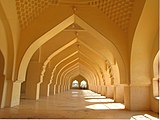
Arches Inside the Jama Mosque.

Jama Masjid interior

Long Interior architectural view of the Jama Masjid


References[]
- ^ Jump up to: a b c d "Gulbarga". Archived from the original on 4 June 2011. Retrieved 2 October 2009.
- ^ "Gulbarga Fort". Retrieved 2 October 2009.
- ^ Jump up to: a b c d e f g "Gulbarga". Karnataka Online. Retrieved 4 November 2009.
- ^ Jump up to: a b c d e f g "Gulbarga". History (link page). National Informatics Centre, Gulbarga. Retrieved 10 November 2009.
- ^ Jump up to: a b c d e f g "Gulbaraga". Retrieved 10 November 2009.
- ^ Joshi p.35-36
- ^ Jump up to: a b c "Gulbarga Fort". British Library On-Line gallery. Retrieved 7 November 2009.
- ^ Jump up to: a b "Asuf Gunj, Gulbarga". British Library On Line gallery. Retrieved 10 November 2009.
- ^ Sen, Sailendra (2013). A Textbook of Medieval Indian History. Primus Books. pp. 106–108. ISBN 978-9-38060-734-4.
- ^ Jump up to: a b "Heritage Areas". National Informatics centre, Karnataka. Retrieved 10 November 2009.
- ^ Joshi, P. M.; M. A. Nayeem; Teotonio R. De Souza (1996). Mediaeval Deccan history: commemoration volume in honour of Purshottam ... Art and Architecture of Bidar. Popular Prakashan. pp. 44–45. ISBN 81-7154-579-3. Retrieved 7 November 2009.
- ^ Jump up to: a b "Gulbarga". Karnataka Tourism. Archived from the original on 1 October 2009. Retrieved 10 November 2009.
- ^ "Sasanian Royal Emblems and their Reemergence in the Fourteenth-Century Deccan" (PDF). Archived from the original (PDF) on 5 September 2004. Retrieved 4 November 2009.
- ^ Cumming, Sir John (2006). Revealing India's Past. Gulbarga Fort. Read Books. p. 424. ISBN 1-4067-0408-3. Retrieved 8 November 2009.
- ^ Sathyan, B. N. Sri (1965). Karnataka State Gazetteer: Gulbarga. Gulbarga fort. The Director of Print., Stationery and Publications at the Govt. Press, Government of Karnataka. pp. 218 and 462. Retrieved 10 November 2009.
- ^ Michell, George; Mark Zebrowski (1999). Architecture and art of the Deccan sultanates, Volume 1. Solah Khmaba Mosque. Cambridge University Press. pp. 66–67. ISBN 0-521-56321-6. Retrieved 7 November 2009.
- ^ "Gulbarga travel". Kerala and South India Tourism. Archived from the original on 10 February 2010. Retrieved 10 November 2009.
- ^ "Gulbarga". Retrieved 10 November 2009.
External links[]
| Wikimedia Commons has media related to Gulbarga Fort. |
- Forts in Karnataka
- Gulbarga
- Buildings and structures in Gulbarga district