Havelock Parish, New Brunswick
Havelock | |
|---|---|
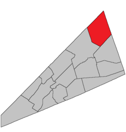 Location within Kings County, New Brunswick. | |
| Coordinates: 45°50′N 64°35′W / 45.84°N 64.59°W | |
| Country | |
| Province | |
| County | Kings County |
| Erected | 1859 |
| Area | |
| • Land | 349.23 km2 (134.84 sq mi) |
| Population (2016)[1] | |
| • Total | 1,061 |
| • Density | 3.0/km2 (8/sq mi) |
| • Change 2011-2016 | |
| • Dwellings | 550 |
| Time zone | UTC-4 (AST) |
| • Summer (DST) | UTC-3 (ADT) |

Havelock is a civil parish in Kings County, New Brunswick, Canada.[2]
For governance purposes it forms the local service district of the parish of Havelock,[3] which further includes the western part of the service area of Havelock Inside.[a] The local service district is a member of Regional Service Commission 8 (RSC8).[4]
Origin of name[]
The parish was named in honour of Henry Havelock, commander of British forces at the Siege of Lucknow in 1857, who died shortly after the siege was lifted.[5]
History[]
Havelock was erected in 1859 from the eastern polling district of Studholm Parish.[6]
In 1871 part of Havelock along Windgap Brook was returned to Studholm.[7]
Boundaries[]
Havelock Parish is bounded:[2][8][9]
- on the northwest by the Queens County line;
- on the east by the Westmorland County line;
- on the southeast by a line running north 66º east[b] from the northeastern corner of a grant to Jacob Smith, about 975 metres north of the junction of Plumweseep Road and Back Road;
- on the west by a line beginning on the Cardwell Parish line near the Old Mine Road west of Dunsinane, then running northwesterly along the prolongation of the southwestern line of a grant to James Caruth, which is on the southern bank of Windgap Brook and on the eastern side of Jordan Mountain Road, until it strikes Windgap Brook, then upstream to the prolongation of Miller Road, then north-northwesterly along the prolongation, the length of Miller Road, and the northerly prolongation of Miller Road until it strikes the Queens County line.
Communities[]
Communities at least partly within the parish.[8][9][12] italics indicate a name no longer in official use
Bodies of water[]
Bodies of water[c] at least partly within the parish.[8][9][12]
- Canaan River
- Millstream River
- Smiths Creek
- Square Meadow Creek
Other notable places[]
Parks, historic sites, and other noteworthy places at least partly within the parish.[8][9][12]
Demographics[]
Population[]
|
Language[]Mother tongue (2016)[1]
|
Access Routes[]
Highways and numbered routes that run through the parish, including external routes that start or finish at the parish limits:[15]
|
|
|
See also[]
Notes[]
References[]
- ^ a b c d "Census Profile, 2016 Census: Havelock, Parish [Census subdivision], New Brunswick". Statistics Canada. Retrieved September 20, 2019.
- ^ a b "Chapter T-3 Territorial Division Act". Government of New Brunswick. Retrieved 13 November 2020.
- ^ "New Brunswick Regulation 84-168 under the Municipalities Act (O.C. 84-582)". Government of New Brunswick. Retrieved 19 July 2020.
- ^ "Communities in each of the 12 Regional Service Commissions (RSC) / Les communautés dans chacune des 12 Commissions de services régionaux (CSR)" (PDF), Government of New Brunswick, July 2017, retrieved 2 February 2021
- ^ Ganong, William F. (1896). A Monograph of the Place-Nomenclature of the Province of New Brunswick. Royal Society of Canada. p. 240. Retrieved 17 March 2021.
- ^ "21 Vic. c. 39 An Act to divide the Parish of Studholm into two separate and distinct Parishes.". Acts of the General Assembly of Her Majesty's Province of New Brunswick, Passed in March and April 1858. Fredericton: Government of New Brunswick. 1858. pp. 89–90. Retrieved 27 March 2021.
- ^ "34 Vic. c. 63 An Act to alter the division line between the Parishes of Studholm and Havelock, in King's County.". Acts of the General Assembly of Her Majesty's Province of New Brunswick. Passed in the Month of May 1871. Fredericton: Government of New Brunswick. 1871. p. 268. Available as a free ebook from Google Books.
- ^ a b c d "No. 118". Provincial Archives of New Brunswick. Department of Natural Resources and Energy Development. Retrieved 14 June 2021. Remainder of parish on maps 129, 130, and 141 at same site.
- ^ a b c d "355" (PDF). Transportation and Infrastructure. Government of New Brunswick. Retrieved 14 June 2021. Remainder of parish on mapbooks 356, 376, 377, 396, and 397 at same site.
- ^ "3 Vic. c. 30 An Act for erecting a part of the Parish or Township of Sussex, in King's County, into a separate and distinct Parish or Township.". Acts of the General Assembly of Her Majesty's Province of New Brunswick, Passed in the Year 1840. Fredericton: Government of New Brunswick. 1840. pp. 14–15. Retrieved 27 March 2021.
- ^ "Historical Magnetic Declination". National Oceanic and Atmospheric Administration. Retrieved 1 March 2021.
- ^ a b c "Search the Canadian Geographical Names Database (CGNDB)". Government of Canada. Retrieved 6 July 2021.
- ^ Statistics Canada: 2001, 2006 census
- ^ 2011 Statistics Canada Census Profile: Havelock Parish, New Brunswick
- ^ Atlantic Canada Back Road Atlas ISBN 978-1-55368-618-7
Places adjacent to Havelock Parish, New Brunswick | ||||||||||||||||
|---|---|---|---|---|---|---|---|---|---|---|---|---|---|---|---|---|
| ||||||||||||||||
| Subdivisions |
|
|---|---|
| Cities | |
| Counties | |
| |
Coordinates: 45°56′05″N 65°24′37″W / 45.934736°N 65.410366°W
- Parishes of Kings County, New Brunswick
- Local service districts of Kings County, New Brunswick