Hendricks County, Indiana
Hendricks County | |
|---|---|
U.S. county | |
 Hendricks County courthouse in Danville | |
 Location within the U.S. state of Indiana | |
 Indiana's location within the U.S. | |
| Coordinates: 39°46′N 86°31′W / 39.77°N 86.51°W | |
| Country | |
| State | |
| Founded | 20 December 1823 (created)[1] Summer 1824 (organized) |
| Named for | William Hendricks |
| Seat | Danville |
| Largest town | Plainfield |
| Area | |
| • Total | 408.78 sq mi (1,058.7 km2) |
| • Land | 406.91 sq mi (1,053.9 km2) |
| • Water | 1.87 sq mi (4.8 km2) 0.46%% |
| Population | |
| • Estimate (2019) | 170,311 |
| • Density | 418.5/sq mi (161.6/km2) |
| Time zone | UTC−5 (Eastern) |
| • Summer (DST) | UTC−4 (EDT) |
| Congressional district | 4th |
| Website | www |
| Indiana county number 32 | |

Hendricks County is a county in the U.S. state of Indiana. As of the 2010 United States Census, the population was 145,448.[2] The county seat is the town of Danville.[3]
Hendricks County is the third largest county in the Indianapolis-Carmel-Anderson, IN Metropolitan Statistical Area. Hendricks County is currently the second fastest-growing county in Indiana and 85th in the nation.[4][5]
History[]
After the American Revolutionary War established US sovereignty over the territory of the upper midwest, the new federal government defined the Northwest Territory in 1787 which included the area of present-day Indiana. In 1800, Congress separated Ohio from the Northwest Territory, designating the rest of the land as the Indiana Territory. President Thomas Jefferson chose William Henry Harrison as the governor of the territory, and Vincennes was established as the future capital. After the Michigan Territory was separated and the Illinois Territory was formed, Indiana was reduced to its current size and geography. By December 1816 the Indiana Territory was admitted to the Union as a state, although much of its territory was still in dispute as to possession by Native Americans. The land containing Hendricks County was brought into the possession of the United States by the Treaty of St. Mary's in 1818 (known as New Purchase).
The eighth General Assembly of the new state of Indiana met at its then-capital town, Corydon, in December 1823, and created three counties before the close of the session, among them being Hendricks, the state's fifty-first county. The bill creating Hendricks County was introduced in the Senate on 9 December and was signed on 20 December[1] by Indiana Governor William Hendricks, in whose honor the new county was named.[6][7] Until its governing structure was organized, the territory was assigned to neighboring counties for legislative and enforcement matters.[8]
Prior to the New Purchase treaty, the territory of Hendricks County had been occupied by the Dakota tribe, although there were no significant native villages within its future borders. The treaty authorized the territory to be surveyed by the federal government, with land being available for settlement thereafter. This survey work began in the Hendricks County area in 1819, and settlers began moving in as soon thereafter (the first in future Hendricks County in Spring 1820)[9] as land filing was authorized, such that by 1823 there were sufficient inhabitants to justify forming a county.[10] Designated commissioners met in July 1824, and on 12 July selected Danville as its county seat. The town plat was filed for record in October 1824; a court house was erected and in operation there by 1826.[11]
Geography[]
The county's low rolling hills are entirely devoted to agriculture or urban development, except for wooded drainages. The West Fork of White Lick Creek flows southeastward through the western part of the county and the East Fork flows southward through the east part of the county; the two flows converge at the south county line.[12] The highest point on the terrain (1030 feet/314 meters ASL) is a small rise 1.5 miles (2.4 km) WNW from Danville.[13]
According to the 2010 United States Census, the county has a total area of 408.78 square miles (1,058.7 km2), of which 406.91 square miles (1,053.9 km2) (or 99.54%) is land and 1.87 square miles (4.8 km2) (or 0.46%) is water.[14]
Adjacent counties[]
- Boone County - north
- Marion County - east
- Morgan County - south
- Putnam County - west
- Montgomery County - northwest
Towns[]
- Amo
- Avon
- Brownsburg
- Clayton
- Coatesville
- Danville - county seat
- Lizton
- North Salem
- Pittsboro
- Plainfield
- Stilesville
Unincorporated communities[]
- Belleville
- Camby - part
- Cartersburg
- Clermont Heights[15]
- Friendswood
- Gale
- Hadley
- Hazelwood
- Joppa
- Maplewood
- Montclair
- New Winchester
- Pecksburg
- Raintown
- Reno
- Six Points
- Springtown
- Summit
- Tilden
- Center Valley
Townships[]
Climate[]
| Danville, Indiana | ||||||||||||||||||||||||||||||||||||||||||||||||||||||||||||
|---|---|---|---|---|---|---|---|---|---|---|---|---|---|---|---|---|---|---|---|---|---|---|---|---|---|---|---|---|---|---|---|---|---|---|---|---|---|---|---|---|---|---|---|---|---|---|---|---|---|---|---|---|---|---|---|---|---|---|---|---|
| Climate chart (explanation) | ||||||||||||||||||||||||||||||||||||||||||||||||||||||||||||
| ||||||||||||||||||||||||||||||||||||||||||||||||||||||||||||
| ||||||||||||||||||||||||||||||||||||||||||||||||||||||||||||
In recent years, average temperatures in Danville have ranged from a low of 18 °F (−8 °C) in January to a high of 86 °F (30 °C) in July, although a record low of −27 °F (−33 °C) was recorded in January 1994 and a record high of 106 °F (41 °C) was recorded in July 1936. Average monthly precipitation ranged from 2.41 inches (61 mm) in February to 4.42 inches (112 mm) in July.[16]
Transportation[]
Airport[]
- 2R2 - Hendricks County Airport
Major highways[]
Demographics[]
| Historical population | |||
|---|---|---|---|
| Census | Pop. | %± | |
| 1830 | 3,975 | — | |
| 1840 | 11,264 | 183.4% | |
| 1850 | 14,083 | 25.0% | |
| 1860 | 16,953 | 20.4% | |
| 1870 | 20,277 | 19.6% | |
| 1880 | 22,981 | 13.3% | |
| 1890 | 21,498 | −6.5% | |
| 1900 | 21,292 | −1.0% | |
| 1910 | 20,840 | −2.1% | |
| 1920 | 20,291 | −2.6% | |
| 1930 | 19,725 | −2.8% | |
| 1940 | 20,151 | 2.2% | |
| 1950 | 24,594 | 22.0% | |
| 1960 | 40,896 | 66.3% | |
| 1970 | 53,974 | 32.0% | |
| 1980 | 69,804 | 29.3% | |
| 1990 | 75,717 | 8.5% | |
| 2000 | 104,093 | 37.5% | |
| 2010 | 145,448 | 39.7% | |
| 2019 (est.) | 170,311 | [17] | 17.1% |
| US Decennial Census[18] 1790-1960[19] 1900-1990[20] 1990-2000[21] 2010-2019[2] | |||
2010 census[]
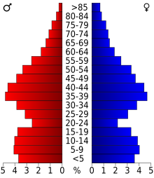
As of the 2010 United States Census, there were 145,448 people, 52,368 households, and 39,698 families in the county.[22] The population density was 357.4 inhabitants per square mile (138.0/km2). There were 55,454 housing units at an average density of 136.3 per square mile (52.6/km2).[14] The racial makeup of the county was 90.1% white, 4.9% black or African American, 2.1% Asian, 0.2% American Indian, 1.1% from other races, and 1.6% from two or more races. Those of Hispanic or Latino origin made up 3.0% of the population.[22] In terms of ancestry, 28.3% were German, 16.2% were English, 15.2% were Irish, and 9.4% were American.[23]
Of the 52,368 households, 40.3% had children under the age of 18 living with them, 61.9% were married couples living together, 9.8% had a female householder with no husband present, 24.2% were non-families, and 19.8% of all households were made up of individuals. The average household size was 2.71 and the average family size was 3.12. The median age was 36.7 years.[22]
The median income for a household in the county was $47,697 and the median income for a family was $77,397. Males had a median income of $54,945 versus $38,919 for females. The per capita income for the county was $28,880. About 4.3% of families and 5.7% of the population were below the poverty line, including 7.3% of those under age 18 and 5.3% of those age 65 or over.[24]
Government[]
The county government is a constitutional body, and is granted specific powers by the Constitution of Indiana, and by the Indiana Code.
County Council: The legislative branch of the county government; controls spending and revenue collection in the county. Representatives are elected to four-year terms from county districts. They set salaries, the annual budget, and special spending. The council has limited authority to impose local taxes, in the form of an income and property tax that is subject to state level approval, excise taxes, and service taxes.[25][26]
Board of Commissioners: The executive body of the county; commissioners are elected county-wide to staggered four-year terms. One commissioner serves as president. The commissioners execute acts legislated by the council, collect revenue, and manage the county government.[25][26]
Court: The county maintains a small claims court that handles civil cases. The judge on the court is elected to a term of four years and must be a member of the Indiana Bar Association. The judge is assisted by a constable who is also elected to a four-year term. In some cases, court decisions can be appealed to the state level circuit court.[26]
County Officials: The county has other elected offices, including sheriff, coroner, auditor, treasurer, recorder, surveyor, and circuit court clerk. These officers are elected to four-year terms. Members elected to county government positions are required to declare party affiliations and to be residents of the county.[26]
Hendricks County is part of Indiana's 4th congressional district; Indiana Senate districts 23 and 24;[27] and Indiana House of Representatives districts 28, 40, 47 and 91.[28]
See also[]
References[]
- ^ Jump up to: a b Hadley (1914), p. 8. However, p. 44 of Hadley gives date as 29 December 1823.
- ^ Jump up to: a b "Hendricks County QuickFacts". US Census Bureau. Archived from the original on 7 June 2011. Retrieved 20 September 2011.
- ^ "Find a County". National Association of Counties. Archived from the original on 31 May 2011. Retrieved 7 June 2011.
- ^ Hendricks County ranks 85th in population growth
- ^ "Counties in Indiana". Archived from the original on 27 September 2011. Retrieved 30 December 2007.
- ^ "Profile for Hendricks County IN". ePodunk. Archived from the original on 13 November 2012. Retrieved 22 September 2012.
- ^ Gannett, Henry (1905). The Origin of Certain Place Names in the United States. Govt. Print. Off. p. 154.
- ^ Hadley, John V. History of Hendricks County, Indiana . . BF Brown Co., Indianapolis. pp. 8, 44, 45 (1914)
- ^ Hadley (1914), p. 42
- ^ Hadley (1914), p. 41
- ^ Hadley (1914), p. 46
- ^ Hendricks County IN (Google Maps, accessed 29 August 2020)
- ^ Hendricks County High Point, Indiana (PeakBagger.com, accessed 29 August 2020)
- ^ Jump up to: a b "Population, Housing Units, Area, and Density: 2010 - County". US Census Bureau. Archived from the original on February 13, 2020. Retrieved 10 July 2015.
- ^ Clermont Heights, Lincoln Township IN (Google Maps, accessed 29 August 2020)
- ^ Jump up to: a b "Monthly Averages for Danville IN". The Weather Channel. Retrieved 27 January 2011.
- ^ "Population and Housing Unit Estimates". Retrieved May 21, 2020.
- ^ "US Decennial Census". US Census Bureau. Retrieved July 10, 2014.
- ^ "Historical Census Browser". University of Virginia Library. Retrieved July 10, 2014.
- ^ "Population of Counties by Decennial Census: 1900 to 1990". US Census Bureau. Retrieved July 10, 2014.
- ^ "Census 2000 PHC-T-4. Ranking Tables for Counties: 1990 and 2000" (PDF). US Census Bureau. Retrieved July 10, 2014.
- ^ Jump up to: a b c "Profile of General Population and Housing Characteristics: 2010 Demographic Profile Data". US Census Bureau. Archived from the original on February 13, 2020. Retrieved 10 July 2015.
- ^ "Selected Social Characteristics in the US – 2006-2010 American Community Survey 5-Year Estimates". US Census Bureau. Archived from the original on February 14, 2020. Retrieved 10 July 2015.
- ^ "Selected Economic Characteristics – 2006-2010 American Community Survey 5-Year Estimates". US Census Bureau. Archived from the original on February 14, 2020. Retrieved 10 July 2015.
- ^ Jump up to: a b Indiana Code. "Title 36, Article 2, Section 3". IN.gov. Retrieved 16 September 2008.
- ^ Jump up to: a b c d Indiana Code. "Title 2, Article 10, Section 2" (PDF). IN.gov. Retrieved 16 September 2008.
- ^ "Indiana Senate Districts". State of Indiana. Retrieved 14 July 2011.
- ^ "Indiana House Districts". State of Indiana. Retrieved 14 July 2011.
- ^ Leip, David. "Atlas of US Presidential Elections". uselectionatlas.org. Retrieved 17 May 2018.
Further reading[]
- Balough, Linda and Betty Bartley. A Pictorial History of Hendricks County, Indiana. Marceline: Walsworth Publishing Company (1999). ISBN 1-57864-074-1
- Hadley, John Vestal. History of Hendricks County, Indiana, her people, industries and institutions. Charleston: Nabo Press (2010). ISBN 1-178-24317-6
External links[]
| Wikimedia Commons has media related to Hendricks County, Indiana. |
- Hendricks County Government
- Hendricks County Economic Development Partnership
- Hendricks County Convention and Visitors Bureau
- Leadership Hendricks County
- City-Data.com Comprehensive Statistical Data and more about Hendricks County
| show Places adjacent to Hendricks County, Indiana |
|---|
| show Municipalities and communities of Hendricks County, Indiana, United States |
|---|
| show Indianapolis metropolitan area |
|---|

Coordinates: 39°46′N 86°31′W / 39.77°N 86.51°W
| show Authority control |
|---|
- Indiana counties
- Hendricks County, Indiana
- 1824 establishments in Indiana
- Populated places established in 1824
- Indianapolis metropolitan area