Hirschland
show This article may be expanded with text translated from the corresponding article in French. (December 2008) Click [show] for important translation instructions. |
Hirschland
Hírschlànd | |
|---|---|
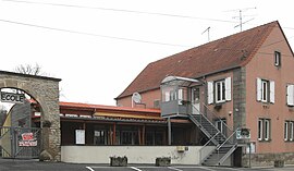 The town hall in Hirschland | |
 Coat of arms | |
show Location of Hirschland | |
 Hirschland | |
| Coordinates: 48°50′16″N 7°06′45″E / 48.8378°N 7.1125°ECoordinates: 48°50′16″N 7°06′45″E / 48.8378°N 7.1125°E | |
| Country | France |
| Region | Grand Est |
| Department | Bas-Rhin |
| Arrondissement | Saverne |
| Canton | Ingwiller |
| Government | |
| • Mayor (2020–2026) | Guy Dierbach[1] |
| Area 1 | 10.73 km2 (4.14 sq mi) |
| Population (Jan. 2018)[2] | 315 |
| • Density | 29/km2 (76/sq mi) |
| Time zone | UTC+01:00 (CET) |
| • Summer (DST) | UTC+02:00 (CEST) |
| INSEE/Postal code | 67201 /67320 |
| Elevation | 244–332 m (801–1,089 ft) |
| 1 French Land Register data, which excludes lakes, ponds, glaciers > 1 km2 (0.386 sq mi or 247 acres) and river estuaries. | |


Hirschland is a commune in the Bas-Rhin department in Grand Est in north-eastern France.
Hirschland is some twelve kilometres (seven miles) to the northwest of Phalsbourg, beside the autoroute towards Sarre-Union and, further to the west, Metz.
See also[]
References[]
- ^ "Répertoire national des élus: les maires". data.gouv.fr, Plateforme ouverte des données publiques françaises (in French). 2 December 2020. Retrieved 7 December 2020.
- ^ "Populations légales 2018". INSEE. 28 December 2020.
| Wikimedia Commons has media related to Hirschland. |
| show Authority control |
|---|
This Bas-Rhin geographical article is a stub. You can help Wikipedia by . |
Categories:
- Communes of Bas-Rhin
- Bas-Rhin geography stubs