History of the Berlin U-Bahn
This article needs additional citations for verification. (October 2015) |
This article may require copy editing for fixing the clunky translations from German, which make the article at times unreadable. (July 2021) |
The Berlin U-Bahn had its origins in 1880 with an idea of the entrepreneur Werner Siemens to build a subway in Berlin. In the nine years after the founding of the German Empire, the population of Berlin rose by over a third, causing increasing traffic problems. In 1896, Siemens & Halske began to construct the first stretch of overhead railway. On 1 April 1897, the company had begun to build electrically elevated and underground railways in Berlin. In 1929 the Berlin transport company was formed and took over the further construction and operation of the network. In 1938 the company was renamed BVG. Since 1994, the BVG has been a public institution.
The route between Stralauer Tor and Potsdamer Platz (today largely U1) was the first line to open, on 18 February 1902. Already on 15 February was the "Minister ride" preceded by the wayside in passenger traffic of the Zoologischer Garten was reached but only from March 11. Four additional routes were constructed before the First World War. In the Weimar Republic, hyperinflation initially prevented further expansion of the network. Only in 1923 again a new metro line was inaugurated that had a wider car with the so-called Großprofil (large profile). In the "Golden Twenties" and the early 1930s, then new routes of this type have been handed over to the driving operation, even in small profiles, there were new openings.
In the era of Nazism, no further stations were built. During the Second World War, many stations were destroyed in Allied air raids. Towards the end of the Battle of Berlin in early May 1945, the north-south tunnel was demolished and wide sections of the subway flooded. The reconstruction of the existing network before the war was finished only in 1950.
Construction of the Berlin Wall in August 1961 brought new restrictions: lines C (later U6) and D (later U8) ran through tunnels and stations in East Berlin without stopping – the exception was the border crossing at Friedrichstraße station. The Warschauer Straße and Potsdamer Platz stations were decommissioned. While U-Bahn construction continued in West Berlin, in East Berlin, only the Tierpark station (line E) opened, in 1973. From 1985 to 1989 the line E (today: U5) was extended from Tierpark to Hönow.
On 11 November 1989, just two days after the Wall fell, the first formerly closed station, Jannowitzbrücke, was reopened as a border crossing point. On 22 December, the station Rosenthaler Platz followed, on 12 April the only accessible from West Berlin station Bernauer Strasse, all located on the U8. On 1 July 1990, all other former ghost stations were finally reopened. With the merging of the networks, U2 was reopened in 1993. In 1995, the U1 was reinstated from Kreuzberg via the Oberbaumbrücke to Friedrichshain on Warschauer Straße station. After that, only the located on the U2 Station Mendelssohn-Bartholdy-Park (October 1998) and were the short portion of Vinetastraße to Pankow (September 2000) reopened. The tight budgetary situation of Berlin since then has stagnated further expansion.
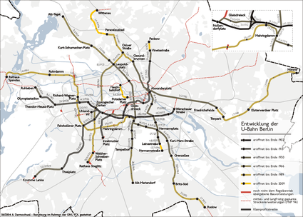
The construction of the Berlin U-Bahn occurred in three major phases:
- Up to 1913 – the construction of the Kleinprofil (small profile) network in Berlin, Charlottenburg, Schöneberg, and Wilmersdorf;
- Up to 1930 – the introduction of the Großprofil (large profile) network that established the first north–south lines;
- From 1953 on – further development after World War II.
Phase 1[]
Initial lines[]


At the end of the 19th century, city planners in Berlin were looking for solutions to the increasing traffic problems facing the city. As potential solutions, industrialist and inventor Werner von Siemens suggested the construction of elevated railways, while AEG proposed an underground system. Berlin city administrators feared that an underground would damage the sewers and therefore favoured an elevated railway which would follow the path of the former city walls. However, the neighbouring city of Charlottenburg did not share Berlin's fears, and opposed the idea of an elevated railway running along Tauentzienstraße. After years of negotiations, official works began on a mostly elevated railway on 10 September 1896. The railway would run between Stralauer Tor and Zoologischer Garten, with a short spur to Potsdamer Platz. Known as the "Stammstrecke", the route was inaugurated on 15 February 1902, to immediate popularity. Before the year ended, the railway had been extended: by 17 August, east to Warschauer Brücke (Warschauer Straße); and, by 14 December, west to Knie (Ernst-Reuter-Platz). Construction for the Charlottenburg section began on 1 January 1900.
In 1902, the train lines consisted as follows:
- K1: Warschauer Brücke – (Gleisdreieck – Potsdamer Platz)
- K2: Warschauer Brücke – (Gleisdreieck – Zoologischer Garten)
- K3: Potsdamer Platz – (Gleisdreieck – Zoologischer Garten)
Charlottenburg Extension[]
After the opening of the original route further plans to extend the three route branches emerged: on Charlottenburg city to Wilhelmplatz (today's Richard-Wagner-Platz) and in the direction Reichskanzlerplatz (today: Theodor-Heuss Platz),[1] from Potsdamer Platz, starting in the center of Berlin and by the Warsaw road to Frankfurter Tor[2] The fastest way negotiations with the young and up-and-coming city district Charlottenburg were completed because there was a lot of vacant lands that could be developed. The most important negotiating point was to build a path for on the Wilhelmsplatz. Here the extension along the Berliner Straße (today's ) would have offered, but there was driving at the time the and parallel traffic did not seem sensible. Therefore, should this route under the Bismarckstraße further extend towards the west and then in an arc to the town hall. Under the working title Krumme Straße the station was initially named Bismarckstraße (today: Deutsche Oper) and on the railhead Wilhelmplatz planned. May 1906. The opening of the line between Knie and Wilhelmplatz took place on the 14th. Both metro lines now drove to Bismarckstraße, but only the branch to Potsdamer Platz traversed line also drove up to the Wilhelmsplatz.
Whilst this route was under construction, the and the city of Charlottenburg on a direction facing Berlin-Westend agreed. Therefore, a plan amendment was necessary at the planned station of Bismarckstraße, because here the line was to branch off to the Westend. Therefore, the station was built as the first four-track metro station in Germany. Of the two inner tracks, the route to Wilhelmsplatz should go from the outer to Westend. This created an unusual situation: Although the short section was planned to the Charlottenburg city hall like the main route, it has now been the route to Westend.
Since the western Charlottenburg area was still completely undeveloped, the route could provide no gains in their early years. Therefore, the overhead railway company was negotiating with the city of Charlottenburg and the other property owners in order to compensate for the deficit path. This contract was signed and completed on 23 June 1906.
For the route westwards along Charlottenburg, the following stations were to be built:
- Bismarckstraße (today's: Deutsche Oper)
- Sophie-Charlotte-Platz
- Kaiserdamm
- Reichskanzlerplatz (today's: Theodor-Heuss-Platz, the end terminal)
On 16 March 1908, the sailed Emperor Wilhelm II, opened the line, In reference to the "Minister ride", the first time this route. It was officially inaugurated on 29 March 1908. The two existing lines went no further until Reichskanzlerplatz; rather, a third line was opened, which only ran between Bismarck Street and Reichskanzlerplatz.
At the opening of the Deutsches Stadion on 8 June 1913 was the stretch with the new terminus Stadion (Sportpark also included) and the shell station Neu-Westend. The corresponding Grunewald workshop was completed in January 1913. Built for the power supply of the metro nearby power plant Unterspreewald on Wiesendamm in Ruhleben had already started operation in 1911.[3]
Because of the greatly expanded route length the previous workshop in Rudolfstraße (or Warschauer Brücke) now no longer sufficed. The desire for a new workshop was created. Therefore, they sought a suitable site. Since the Prussian forest administration wanted to market their site of the Grunewald profitably, the interests of both partners met. Just bought the overhead railway company 14 hectares land to build their new operating workshop. At the same time, it undertook a route extension to the stadium station (today: Olympia-Stadion). The overhead railway company got a grant from the Forestry Administration of 200,000 Mark. As it only took place operating occasional services here, regular service was not provided. Together with the extension to the stadium station, only a shell for the Neu-Westend station was constructed, because a traffic demand at that time did not yet exist.
The planned eastern extension of the main line from Warschauer Brücke to Frankfurter Tor was not realized. Built by the overhead railway company as a precursor and operated as a tram from Warschauer Brücke to Central-Viehhof metro station, it was acquired in 1909 by the city and went on 1 January 1910 at the Trams in Berlin[4]
Eastern Extension along Spittelmarkt[]
In Berlin's city centre, Potsdamer Platz was disconnected — to be replaced by Leipziger Platz (Potsdamer Platz) — to allow an extension to the spur, construction began on 15 December 1905. The line underneath Leipziger Straße to Spittelmarkt opened in 1908.
The lines in 1908 included:
- K1: Warschauer Brücke – Potsdamer Platz – Spittelmarkt
- K3: Wilhelmplatz (Charlottenburg) – Wittenbergplatz – Potsdamer Platz – Spittelmarkt
It was extended to Alexanderplatz by July 1913, with the Wilhelmplatz–Alexanderplatz route swiftly becoming the most heavily traveled of the Berlin U-Bahn. Three-and-a-half weeks later, on 27 July 1913, the northern extension to the S-Bahn station (Schönhauser Allee), which was originally called Nordring was also opened. Construction also began in March 1910.
Schöneberg needs a U-Bahn[]
In a bid to secure its own improvement, Schöneberg also wanted a connection to Berlin. The elevated railway company did not believe such a line would be profitable, so the city took it upon itself to build the first locally financed underground in Germany. Running as a subsurface railway from Hauptstraße, the 2.9 km (1.8 mi) line needed a second, underground station at its Nollendorfplatz terminus since the established station there was part of the elevated railway. Construction began on 8 December 1908. The line took two years to construct; it was opened on 1 December 1910.
U-Bahn towards Dahlem and Kurfürstendamm[]
In the summer of 1907, the elevated railway company of the new city of Wilmersdorf suggested the building of an underground line to the Wilmersdorf area. It suggested a line to Nürnberger Platz and, if Wilmersdorf would pay for it, to Breitenbachplatz. Since Wilmersdorf municipality had poor transport connections, the Wilmersdorf city fathers were pleased to take up this suggestion. The royal domain of Dahlem, which was south of Wilmersdorf and was still undeveloped, also supported a U-bahn connection and wanted it extended from Breitenbachplatz to Thielplatz.
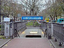
However, the future line would run partly through the city of Charlottenburg, which saw the city of Wilmersdorf as a major competitor for the settlement of wealthy ratepayers. Long negotiations ensued, until finally in the summer of 1910 a solution was found: an additional line would be built under the Kurfürstendamm to Uhlandstraße. Work began on these lines in the same summer.
The double-track Wittenbergplatz station, which only had two side platforms, had to be completely rebuilt. The new station required five platforms with a sixth prepared for development and an entrance hall. The cities of Wilmersdorf and Charlottenburg submitted many suggestions for its design. Finally, the house architect of the elevated railway company, Alfred Grenander, was appointed to design the station on the recommendation of the royal police chief.
The additional line to Uhlandstraße branched at Wittenbergplatz and had no intervening stations, but it was intended to be extended to Halensee. Nevertheless, the only addition to the line has been the building in 1961 of the Kurfürstendamm interchange station with the U9. It is still planned to extend the line to the west and preparations were made for it in the building of Internationales Congress Centrum on Neuen Kantstraße. In addition provisions have been made for a U1 station under the U7 station at Adenauerplatz.
After a relatively short construction period the Kurfürstendamm line, as it was called, was opened together with the Dahlem line on 12 October 1913. The length of the additional lines totaled about 10 km. These were the last sections of the Berlin U-Bahn built before World War I.
The Dahlem line stations consists as follows:
- Wittenbergplatz (awaiting extension)
- Nürnberger Platz (1959 closed and replaced by Spichernstraße)
- Hohenzollernplatz
- Fehrbelliner Platz
- Heidelberger Platz
- Rüdesheimer Platz
- Breitenbachplatz (originally planned to be Rastatter Platz)
- Podbielskiallee
- Dahlem-Dorf
- Thielplatz (preliminary terminus)
The new Gleisdreieck[]
One of the most dangerous places of the entire U-Bahn network was found at the triangular rail junction at Gleisdreieck, which connected the main route between Warschauer Brücke and Zoologischer Garten with the branch line to Potsdamer Platz. This branch was protected only by signals, so that train-driver inattention could easily lead to a disaster, as happened on 26 September 1908. A U-Bahn train ran into the side of another train, forcing two carriages off the track. One carriage fell over the viaduct and 21 passengers died. As a result, it was decided to change the configuration at Gleisdreieck.
Construction began in May 1912 to replace the rail triangle with two lines built as a grade-separated cross with a new Gleisdreieck interchange station at the intersection. These lines now form part of U1 and U2. The new works were carried out largely with full services operating, although services were briefly interrupted on each line. On 3 November 1912 the new Gleisdreieck station was opened but construction was not completed until August 1913. The connecting track from the Pankow direction to the Warschauer Straße direction continued to operate until the completion of works for construction supply vehicles.
The K1 is therefore withdrawn, but K2 was shortened to Gleisdreieck. Each train is entitled to only one depot per line (Grunewald and Warschauer Brücke).
The final route in 1913 is as follows:
- K2: Warschauer Brücke – Uhlandstraße (became BI)
- K3: Bismarckstraße – Stadion (became AI)
- K4: Wilhelmplatz – Nordring (became AI)
- K5: Warschauer Brücke – Hauptstraße (became BII)
- K6: Nording – Thielplatz (became AII)
- K7: Fehrbelliner Platz – Thielplatz (became AII)
Phase 2[]
Nord-Süd Bahn[]
The early network ran mostly east to west, connecting the richer areas in and around Berlin, as these routes had been deemed the most profitable. In order to open up the network to more of the workers of Berlin, the city wanted north-south lines to be established. Its wishes gained support when, in 1920, the surrounding areas were annexed to form Groß-Berlin ("Greater Berlin"), removing the need for many negotiations, and giving the city much greater bargaining power over the private Hochbahngesellschaft ("elevated railway company"). The city also mandated that new lines would use wider carriages—running on the same, 1,435 mm (4 ft 8+1⁄2 in) standard gauge track-to provide greater passenger capacity; these became known as the Großprofil ("large profile") network.
Construction of the Nord-Süd-Bahn ("North-South railway") connecting Wedding in the north to Tempelhof and Neukölln in the south had started in December 1912 but halted for the First World War. Work resumed in 1919, although the money shortage caused by hyperinflation slowed progress considerably. On 30 January 1923, the first section opened between Hallesches Tor and Stettiner Bahnhof (Naturkundemuseum), with a continuation to Seestraße following two months later.
Desperately underfunded, the new line had to use trains from the old Kleinprofil network; the carriages exits had to be widened to fill the gap to the platforms with wooden boards that passengers jokingly referred to as Blumenbretter ("boards for flower pots"). As it is the line G1 from 1923 to 1928, it was extended to The line branched at Belle-Alliance-Straße, now (Mehringdamm); the continuation south to Tempelhof opened on 22 December 1929, the branch to Grenzallee on 21 December 1930.
The stretch towards Neukölln is opened in various stages, among it is Line G1.
- Hallesches Tor – Gneisenaustraße (19 April 1924)
- Gneisenaustraße – Hasenheide (14 December 1924)
- Hasenheide – Bergstraße (11 April 1926)
- Bergstraße – Grenzallee (21 December 1930)
The other extension as a branch to Kreuzberg was opened on 14 February 1926 and whereas another extension to Tempelhof opened on 22 December 1929, which is called Line G2.
GN Line[]
In 1912, plans were approved for AEG to build its own north–south underground line, named the GN-Bahn after its termini, Gesundbrunnen and Neukölln, via Alexanderplatz. Financial difficulties stopped the construction in 1919; the liquidation of AEG-Schnellbahn-AG, and Berlin's commitment to the Nord-Süd-Bahn, prevented any further development until 1926.
The first section opened on 17 July 1927 between Boddinstraße and Schönleinstraße, with the intermediate Hermannplatz becoming the first station at which passengers could transfer between two different Großprofil lines. Sections to the north, which required the relocation of the Kottbusser Tor station, opened in stages. The line is called G3 until 1928, and it was renumbered to Line D at the point of time.
The completed route from Gesundbrunnen to Leinestraße — was opened on 18 April 1930.
The last small profile network opens[]
The small profile network was only slightly extended during the Weimar Republic. The new arrangement at Gleisdreieck was completed. The additional line created by the conversion of the three-way junction to a cross at Gleisdreieck was extended under Kurfürstenstraße to Nollendorfplatz and was opened on 24 October 1926 together with the rebuilt Nollendorfplatz station. The basic fit-out of the Kurfürstenstraße station bears witness to the difficult financial times. As part of this work, the Nollendorfplatz station was completely rebuilt to incorporate the Schöneberg line (now U4), which had continued to be independently operated after its take over by the city of Berlin in 1920. The new Nollendorfplatz station has two underground platforms, one below the other and looking identical. The Schöneberg line ends on the higher level across the platform from trains coming from Wittenbergplatz. Trains run from the lower level to Schöneberg and Wittenbergplatz, also allowing cross-platform transfers. The elevated station of today's U2 remained completely unchanged. Its impressive dome was destroyed in World War II and a simplified dome was only re-established on the U-Bahn's 100-year anniversary in 2002.
The routes K8 and K2 were merged to become K2 in 1926.
The southern extension to Dahlem[]
In the south of the Wilmersdorfer-Dahlem-Bahn, it did not look favorable for an extension. The track was highly deficient, from even drove only a so-called "solo vehicle" (a wagon) until Thieplatz. The city of Berlin was very much opposed to taking this route from the Dahlem Council or the Prussian Treasury. But in 1926 the situation improved considerably. The Prussian state wanted the route Berlin handed over free of charge and free of debt. At the same time offering the , the great, still, farming areas had in the south of Berlin, free land and a construction cost assumption for an extension to Krumme Lanke. Thus, Berlin was in fact paid to three kilometers underground.
These three stations do include:
- Krumme Lanke
- Onkel Toms Hütte
- Oskar-Helene-Heim
The section went on 22 December 1929 in operation. The still so-named station Onkel Toms Hütte was given this by a lying near local. The Krumme Lanke station received a very businesslike entrance building, which is one of the late works of Alfred Grenander. The terminus of today's U3 is named after the nearby lake Krumme Lanke. An extension of the line to a station for Mexikoplatz is possible to link the subway to the Wannseebahn. The expected demand is however expected to be relatively low.
The U-Bahn under the Frankfurter Allee[]
Before control of the U-Bahn network was handed over completely to the BVG in 1929, the Hochbahngesellschaft started construction on a final line that, in contrast to its previous lines, was built as part of the Großprofil network. It was supposed to be a branch for the U2, which starts from Klosterstraße in 1908. The E line ran under Frankfurter Allee, for which the company had received the concession in 1914, between Alexanderplatz and Friedrichsfelde before the World War II.
The construction work proceeded since 1927 without delay or undue expense, and the first servicing station was established in the eastern part of the city; the line opened on 21 December 1930. The several stations include:
- Alexanderplatz (interchange)
- Schillingstraße
- Strausberger Platz
- Memeler Straße (today's Weberwiese)
- Petersburger Straße (today's Frankfurter Tor)
- Samariterstraße
- Frankfurter Allee (interchange with S-Bahn)
- Magdalenenstraße
- Lichtenberg (interchange with Ringbahn)
- Friedrichsfelde (end terminus and depot)
End of the second expansion[]
In recent years, the Weimar Republic nor the Nord-Süd Bahn were extended and line E was opened along Frankfurter Allee. The network reached a distance of 76 kilometers length. 1931 were transported 265.5 million passengers. During the Great Depression, the city lacked the money for the construction of other subway lines. In the 1930s, has been built primarily on the new underground north-south S-Bahn. In addition, have long been usual with bus and tram, assigned to the individual subway lines line designations. Previously, these routes were always named only after the plan name, for example, "GN-Bahn" or "Nord-Süd Bahn". But already at the last opening more and more language problems, for example, "Wilmersdorfer-Dahlem-Bahn" revealed. In the late 1920s, the names of letters and Roman numerals were finally introduced. These were made, however, only gradually.
| 1931 Berlin U-Bahn routes | ||||
|---|---|---|---|---|
| Kleinprofil network | Großprofil network | |||
| AI | Pankow (Vinetastraße) – Ruhleben | CI | Seestraße – Grenzallee | |
| AII | Pankow (Vinetastraße) – Krumme Lanke | CII | Seestraße – Tempelhof | |
| AIII | Städtische Oper – Wilhelmplatz | D | Gesundbrunnen – Leinestraße | |
| BI | Warschauer Brücke – Hauptstraße | E | Alexanderplatz – Friedrichsfelde | |
| BII | Warschauer Brücke – Uhlandstraße | |||
Nazi Rule, the Second World War and Immediate Aftermath[]
| Planned Lines | |
|---|---|
| AI | Pankow (Breite Straße) – Ruhleben |
| AII | Alexanderplatz – Kleinmachnow |
| B | Thaerstraße – Lichterfelde West |
| CI | Otawistraße – |
| CII | Ordensmeisterstraße – Herminpfad |
| D | Christianiastraße () – Britz |
| E | Beusselstraße – Treskowallee |
| FI | Marzahn – |
| FII | Weißensee – Lankwitz |
| FIII | – Kladow |
| G | Lübars – Marienfelde |
| H | Runder Platz – Buschkrug |
| R | Ring Line |
The seizure of power by the Nazi Party brought many changes that affected Germany, including the U-Bahn. Most notably, the Nazi flag was hung in every station, and two of the stations were renamed: Reichskanzlerplatz became Adolf-Hitler-Platz on 24 April 1933; and Schönhauser Tor became Horst-Wessel-Platz on 1 May 1934. Extensive plans—mostly the work of architect Albert Speer—were drawn up that included the construction of a circular line crossing the established U-Bahn lines, and new lines or extensions to many outlying districts. Despite such grand plans, no U-Bahn development occurred.
Germania Plans[]
The planned giant new imperial capital of Germany (planned name: "World Capital Germania ') should reach a population of ten million. This is also a significant expansion of the subway network was provided. Numerous subway lines should be built or extended. Most plans designed the new Generalbauinspektor Albert Speer. It was planned alongside the existing Berlin Ringbahn a Berliner "Circle Line". These should all then-existing lines intersect and have about 30 stations. Also, there should be several lines after Spandau, Gatow, Kladow, Lichterfelde, , Weißensee, Karlshorst and Lankwitz give. Portions of this line realized the Senate later with the construction of U7. The metro construction rested but in 1930, because the construction of the new underground Nord-Süd Bahn and Olympiastadion was executed with priority. Only in the summer of 1938 found the first construction work on Reichskanzlerplatz, on Reichstag and the instead. However, it did not come to an extension of the metro network.
World War II[]
During the Second World War, U-Bahn travel soared as car use fell, and many of the underground stations were used as air-raid shelters; however, Allied bombs damaged or destroyed large parts of the U-Bahn system. Although the damage was usually repaired fairly quickly, the reconstructions became more difficult as the war went on. Eventually, on 25 April 1945, the whole system ground to a halt when the power station supplying the network failed.
Even before the beginning of the Second World War, there were noticeable changes in the subway. The brass door handles were replaced by wood. Similarly, the cast-iron brake pads were replaced in the small profile cars, also wood was used there. In addition, the BVG network plans, which were almost exactly Berlin, disappeared.
After the Second World War began on 1 September 1939, the National Socialists immediately ordered the blackout. So on the open stretches of the subway in the evening and at night, no more light was allowed to burn. For better orientation for the passengers, the edges of the platforms, which have long been commonplace, were painted white. Also, blackout discs were used in front of the signal lamps.
On 29 August 1940, the first bomb hit the subway tunnel at Kottbusser Tor. However, as the bomb was a dud, it caused only minor damage to property. As a result, the government of the Reich indicated that air-raid shelters should be built in some subway stations. This happened at the stations Alexanderplatz, Ruhleben, Friedrichstrasse, Gesundbrunnen, Gleisdreieck, Hermannplatz, Moritzplatz, Nollendorfplatz and Seestraße, in the Waisentunnel, in the Eisacktunnel, in the unused tunnel under the Dresdener Strasse as well as on Hermannstraße. The bunkers in the Alexanderplatz, Gesundbrunnen, Hermannstraße and Waisentunnel stations can still be visited today.
Another consequence of the war was that most motor vehicles, including buses, were confiscated. Thus, Berlin relied on rail-bound means of transport, that is S-Bahn, subway and tram. So the number of passengers increased drastically. The S-Bahn carried about 700 million passengers in 1942, the subway about 405 million. This was a new record for both modes of transport. However, these now no longer transported only people, the freight also shifted to the rail. Food, paper and newspapers, machine parts and the post office were also transported.
On 19 July 1944, an aerial mine exploded next to the elevated railway viaduct on Bülowstraße, causing heavy structural faults. It was then provisionally supported with wooden stacks. In the following years, the bomb damage continued to increase. First, the routes were marked on the network, which were not used. Later, only those were marked, on which even more trains drove. The worst day for the subway was 3 February 1945: 27 direct hits on stations and facilities were registered. The tunnel ceiling at Halleschen Tor station was hit by a bomb, killing 43 people. The station Bayerischer Platz, where two trains were, was destroyed by several bombs, with 63 people died. Also hit the northern part of the station, Moritzplatz, where 36 people died. The worst, however, happened at Memeler Strasse (today: Weberwiese), where several bombs were falling at the same time, killing about 200 people.
Although it resembled pure Sisyphean work, the crews tried to repair any damage[citation needed]. It was necessary to maintain the operation as long as possible, whether as a shuttle service or with a transfer from station to station. Gradually, however, the damage was so great that on many sections of an operation was no longer possible and the traffic came to a halt completely. In addition, parts of the tunnels were rededicated. For example, the Grenzallee station and the adjoining section of the tunnel were shut down and leased to an armaments company.
Finally, it was reported on 25 April 1945 that the BVG-owned power plant Unterspree was shot at in Ruhleben. The power supply stopped at 6 o' clock. On this day, only two routes operated: the Wittenbergplatz to Kaiserdamm line and the Kaiserdamm to Ruhleben line. These could no longer be operated. The traffic now rested in the whole of Berlin.
Flooding[]
There were substantial Berlin U-Bahn sections flooded in May 1945. A prominent cause was an intentional sabotage by the detonation of explosives in the Berlin Nord-Süd Tunnel beneath the Landwehr Canal on the morning of 2 May 1945.[5][page needed] By the end of the war, several sections were flooded:

- Rosenthaler Platz – Jannowitzbrücke
- Uhlandstraße – Wittenbergplatz
- Wedding – Gardepionierplatz
- Mehringdamm – Kreuzberg
- Alexanderplatz – Potsdamer Platz
- Alexanderplatz – Frankfurter Allee
There is controversy about the cause of the flooding, with some attributing it to a Nazi order, but insufficient evidence of this has been found and it has not been possible to say with certainty who carried out the sabotage and on whose orders. Similarly, there has been controversy about how many people had lost their lives as a consequence. It is most likely that some of the bodies found later in the tunnel were wounded soldiers who had been dead before the tunnel flooding, since the S-Bahn tunnel station under the Friedrichstrasse station was used in the last days of the war as an emergency military hospital, with trains used as hospital rooms.[6][7] It seems clear that some did die in the flooding, but the discrepancy between the number of bodies recovered and the number anticipated has given rise to conspiracy theories. Current research suggests probably less than 200 deaths were caused by the flooding [5][page needed][8][9]
Waters discharged into one third of Berlin's Underground flooding 63 km of tunnels with 25 further stations.
Another but smaller leak in the tunnel ceiling under the Spree was either caused by German forces exploding the Ebertsbrücke street bridge crossing at the river at the same section, where the tunnel passes underneath, or some months later, after the end of the fighting, by Soviet military engineers who created the hole in the process of clearing the Spree river of large concrete obstacles created by the bridge explosion.
Reconstruction of the Berlin U-Bahn[]
With the entry of the force for unconditional surrender of Nazi Germany by the Soviet Union (with the Battle of Berlin fighting), there were 437 damaged points and 496 damaged vehicles. 144 hits on the underground, 33 on the above-ground lines. It is estimated that there were a total of about 400 victims in the Berlin subway.
The sections were quickly reopened from 14 May 1945; most of them operated as shuttles, due to damaged trains and the lack of crossovers:
- 14 May 1945: Bergstraße – Hermannplatz
- 14 May 1945: Boddinstraße – Schönleinstraße
- 17 May 1945: Knie – Ruhleben
- 17 May 1945: Boddinstraße – Leinestraße
- 18 May 1945: Deutsche Opernhaus – Richard-Wagner-Platz
- 22 May 1945: Rosenthaler Platz – Gesundbrunnen
- 24 May 1945: Frankfurter Allee – Friedrichsfelde
- 26 May 1945: Schönhauser Allee – Alexanderplatz
- 27 May 1945: Schönleinstraße – Kottbusser Tor
- 27 May 1945: Zoologischer Garten – Knie
- 3 June 1945: Kottbusser Tor – Neanderstraße
- 8 June 1945: Thielplatz – Krumme Lanke
- 8 June 1945: Breitenbachplatz – Thielplatz
- 8 June 1945: Hohenzollernplatz – Rüdesheimer Platz
- 9 June 1945: Hermannplatz – Gardepionerplatz
- 11 June 1945: Tempelhof – Belle-Alliance-Straße (closed again on 15 August 1945)
- 11 June 1945: Gardepionerplatz – Belle-Alliance-Straße
- 11 June 1945: Prinzenstraße – Schlesisches Tor
- 13 June 1945: Rosenthaler Platz – Weinmeisterstraße
- 16 June 1945: Weinmeisterstraße – Neanderstraße (Completion of the Line D)
- 16 June 1945: Frankfurter Allee – Petersburger Straße
- 20 June 1945: Schillingstraße – Petersburger Straße
- 21 June 1945: Rüdesheimer Platz – Breitenbachplatz
- 23 June 1945: Schillingstraße – Alexanderplatz (Completion of the Line E)
- 24 June 1945: Nollendorfplatz – Bayerischer Platz
- 24 June 1945: Wittenbergplatz – Kurfürstenstraße
- 4 July 1945: Belle-Alliance-Straße – Hallesches Tor
- 12 July 1945: Seestraße – Kochstraße
- 15 July 1945: Wittenbergplatz – Nürnberger Platz
- 23 July 1945: Wittenbergplatz – Uhlandstraße
- 26 July 1945: Bergstraße – Grenzallee
- 31 July 1945: Märkisches Museum – Potsdamer Platz (skipping a few stations)
- 1 August 1945: Alexanderplatz – Klosterstraße
- 1 August 1945: Pankow – Schönhauser Allee
- 15 September 1945: Halleschem Tor – Kochstraße
- 6 October 1945: Nürnberger Platz – Hohenzollernplatz
- 14 October 1945: Warschauer Brücke – Schlesisches Tor
- 14 October 1945: Prinzenstraße – Hallesches Tor
- 21 October 1945: Wittenbergplatz – Gleisdreieck
- 1 November 1945: Klosterstraße – Märkisches Museum
- 18 November 1945: Gleisdreieck – Potsdamer Platz
- 16 December 1945: Bayerischer Platz – Innsbrucker Platz (Completion of Line B)
The stations that were still closed include Hausvogteiplatz, Kaiserhof, Nollendorfplatz (elevated), Hallesches Tor and Osthafen.
Phase 3[]
Berlin Blockade[]
After the Western Allies carried out a currency reform in the western zones on 20 June 1948, the USSR did the same in the Soviet Occupation Zone of Germany, including the Soviet sector of Berlin. As a result, the Westmark was also introduced in Berlin. In response, the Soviets sealed the transit routes between parts of Berlin, as of 24 June, with the Berlin blockade. The road, rail and boat connections to the surrounding area were not blocked. On 26 June the American General Lucius D. Clay ordered the establishment of the Berlin Airlift. This existed until the abandonment of the transit routes by the Soviets on 12 May 1949.
From 9 July 1948, the subway in West Berlin had to be shut down from 6 pm onwards because the West Berlin power plants could not produce enough electricity. In East Berlin, all routes were used. Also on the later transit lines (line C, later: U6, line D, later: U8) drove trains.
This event weighed heavily on the BVG in addition to the current municipal split. The seat of the BVG was since 1945 in the Potsdamer road. In order to prevent separation of the two halves of the city, a contact office was established on Stralauer Strasse in East Berlin. The then head was Wilhelm Knapp, and so the office was called only the "office Knapp". This was the de facto division of the BVG. From 19 September 1949 the "office Knapp" is now called "BVG East". Thus, the separation of the city's own operation was also de facto completed.
For BVG-Ost, this created a major problem: the maintenance of small-profile vehicles. Because all small-profile workshops were located in West Berlin (Bw Grunewald and Bw Krumme Lanke). The vehicles had to be transported by low loader to the large-profile workshop Friedrichsfelde. To eliminate this problem, the BVG East decided to build a tunnel from line A (today: U2) to line E (today: U5). Construction began in 1951 and was completed in time for the 50th anniversary of the 1952 U-Bahn. The first post-war tunnel construction in Berlin had severely damaged the remnants of the Gray Monastery. The internal route was called "Klostertunnel".
The split of the BVG: 1945–1961[]
The war had damaged or destroyed much of the network; however, 69.5 km (43.2 mi) of track and 93 stations were in use by the end of 1945, and the reconstruction was completed in 1950. Nevertheless, the consequent division of Berlin into East and West sectors brought further changes to the U-Bahn. Although the network spanned all sectors, and residents had freedom of movement, West Berliners increasingly avoided the Soviet sector and, from 1953, loudspeakers on the trains gave warnings when approaching the border, where passage of East Germans into the Western sectors also became subject to restrictions imposed by their government. There was a general strike on 17 June 1953 as well, where the sections were closed:
- A: Pankow – Gleisdreieck
- B: Schlesisches Tor – Warschauer Brücke
- C: Kochstraße – Reinckendorfer Straße
- D: Gesundbrunnen – Kottbusser Tor
- E: Alexanderplatz – Friedrichstraße
Just after the strike, on the following day, train service on line A was resumed and service C was resumed to provide connections to Nordbahnhof and Friedrichstraße.

Between 1953 and 1955, the 200-Kilometre-Plan was drawn up, detailing the future development of the U-Bahn, which would ultimately grow to 200 km (124.3 mi).
1st Phase:
- C: Seestraße – Scharnweberstraße (realised, construction began in 1953)
- A: Vinetastraße – Pankow
- E: Friedrichsfelde – Karlshorst
- CI: Grenzallee – Blaschkoallee (realised)
- CII: Tempelhof – Teltowkanal (partially realised to Mariendorf)
- D: Leinestraße – Britz
2nd Phase:
- C: Scharnweberstraße – Tegel
- D: Gesundbrunnen – Wilhelmsruh
- B: Warschauer Brücke – Bersarinstraße
- CI: Blaschkoallee – Rudow
- D: Gradestraße – Mittenwalder Kleinbahn
- AII: Krumme Lanke – S-Bahnhof Zehlendorf West
- AI: Ruhleben – Spandau
- BII: Uhlandstraße – Halensee
- F: Alexanderplatz – Schloßstraße
3rd Phase:
- F: Alexanderplatz – Weißensee
- G: Stegliz – Amrumer Straße (partially realised)
Extending the C line to run from Tegel to Alt-Mariendorf was considered the highest priority: the northern extension to Tegel was opened on 31 May 1958. In order to circumvent East Berlin, and provide rapid-transport connections to the densely populated areas in Steglitz, Wedding, and Reinickendorf, a third north–south line was needed. The first section of line G was built between Leopoldplatz and Spichernstraße, with the intention of extending it at both ends. It had been planned to open the G line on 2 September 1961, but an earlier opening on 28 August was forced by the announcement of the construction of the Berlin Wall.
Construction of the Berlin Wall[]
GDR state and party leader Walter Ulbricht had replied to the question of the journalist whether there is a need to build a Berlin Wall, on 15 June 1961.
"I understand your question so that there are people in West Germany who need to mobilize the construction workers of the Berlin Wall to erect a Wall. I am not aware of such an intention, because the construction workers of our capital mainly deal with the housing, and their labour is fully exploited, will be fully used. No one has the intention to build a wall"
But a few weeks later, on 12 August, the SED General Secretary ordered the construction of the wall around West Berlin. GDR Interior Minister Karl Maron subsequently gave instructions for changes to the Berlin U-Bahn:
- Line A was closed between Thälmannplatz and Gleisdreieck. The physical division had cut Line A in half. Originally, the Interior Minister wanted West Berlin's Line A to be shortened to Potsdamer Platz, but instead trains used a crossing between Gleisdreieck and Potsdamer Platz to turn back.
- Line B was closed between Warschauer Brücke and Schlesisches Tor and blocked to public access.
- For lines C and D, West Berlin asked to pay for an annual fee of DM 20 million to permit trains to run through East Berlin, although the trains were not allowed to stop on their way. The former stops became Geisterbahnhöfe ("ghost stations"), patrolled by armed East-German border guards. Only at Friedrichstraße, a designated border crossing point, were passengers allowed to disembark.
East Berlin only retained lines A and E.
A further consequence of the Wall was that West Berliners, unwilling to help fund the Soviet-dominated state, boycotted the East-German-controlled S-Bahn, transferring wherever possible to the U-Bahn. For historic reasons, the S-Bahn was owned and operated by the GDR in both East and West Berlin.
West Berlin U-Bahn: The Expansion[]
In West Berlin, housing developments in Britz and Rudow demanded an extension to the CI line. The Grenzallee to Britz-Süd connection opened on 28 September 1963. Guidelines for underground development stipulated that all lines should be linear, with no branches. Thus the extension in the opposite direction from Mehringdamm to Möckernbrücke established a new line: H. "Line H" was never used, however, as its opening on 28 February 1966 coincided with the redesignation of all lines in West Berlin. The new line was named U7, and the Tempelhof to Alt-Mariendorf section—opened the same day—completed the newly designated U6. West Berlin abandoned the letter-based system on 1 March 1966 and replaced it with line numbers 1 through 9, the system is still in place today.
| 1966 U-Bahn line redesignations | ||||||||
|---|---|---|---|---|---|---|---|---|
| Kleinprofil network | Großprofil network | |||||||
| BI | → | 1 | Schlesisches Tor – Ruhleben | CII/CI | → | 6 | Tegel – Alt-Mariendorf | |
| AII | → | 2 | Gleisdreieck – Krumme Lanke | CI/H | → | 7 | Möckernbrücke – Britz-Süd | |
| BIV | → | 3 | Wittenbergplatz – Uhlandstraße | D | → | 8 | Gesundbrunnen – Leinestraße | |
| BIII | → | 4 | Nollendorfplatz – Innsbrucker Platz | G | → | 9 | Leopoldplatz – Spichernstraße | |
| AIII | → | 5 | Deutsche Oper – Richard-Wagner-Platz | |||||
Funds from economically successful West Germany, with its capital in Bonn, to West Berlin were plentiful, allowing major expansions to U-Bahn lines. The U9, from Rathaus Steglitz to Osloer Straße was opened on 30 April 1976 and the U7 was further extended in six sections until it reached Rathaus Spandau on 1 October 1984. When the BVG took over the running of S-Bahn and U-Bahn services in 1984, it incorporated the S-Bahn into the numbering system and thus, using the West German transport system designations of giving new line numbers prefixed by "S" to the S-Bahn and adding the prefix "U" to the existing U-Bahn lines. Thus "line 1" became "U1" etc.
The U8 was extended north from Gesundbrunnen, through the newly built Osloer Straße, to Paracelsus-Bad, which opened on 27 April 1987.
The E Line Extension[]
In contrast, additions to the East Berlin lines, financed by the GDR, were not so frequent. In the 1970s, the E line was extended east to Tierpark, opening on 25 June 1973. There were plans to extend to Karlshorst in the early 1950s/60s, and the new plan after the Tierpark extension was to extend to the Oberschöneweide, very near to Treptow. In the 1980s, a new plan was developed to run along the VnK Railway to Kaulsdorf, and a new stretch to Hönow.
The extension was designed in 1983/84. It was 10.1 km long with nine new stations. Construction began on 1 March 1985; the first section to open was between Biesdorf-Süd and Elsterwerdaer Platz. The section to Hönow was to open on 1 July 1989, just a few months before the fall of the Berlin Wall.
Reunification and reformation of the Berlin U-Bahn[]
On 9 November 1989, following months of unrest, the travel restrictions placed upon East Germans were lifted. Tens of thousands of East Berliners heard the statement live on television and flooded the border checkpoints, demanding entry into West Berlin. Jannowitzbrücke, a former ghost station, was reopened two days later as an additional crossing point. Rosenthaler Platz and Bernauer Straße on the U8 soon followed suit, and by 1 July 1990, all border controls were removed. It took three months to clean the dirt and complete interior refurbishments before the reopening on 1 July 1990.
The Berlin U-Bahn lines were renumbered after the adoption of West German currency on 1 July 1990. For example, the E became U5, and the A became U2, even though U2 was not yet connected to the western side of Berlin and despite the existence of a U2 from Wittenbergplatz to Krumme Lanke. After the reunification of Germany on 3 October 1990, all the Communist-era names of the Berlin stations reverted to their original names:
- Dimitroffstraße → Eberswalder Straße
- Otto-Grotewohl-Straße (before 1986 is called Thälmannplatz) → Mohrenstraße
- Marchlewskistraße → Weberwiese
- Albert-Norden-Straße → Kaulsdorf-Nord
- Heinz-Hoffmann-Straße → Neue Grottkauer Straße
- Paul-Verner-Straße → Louis-Lewin-Straße
- Stadion der Weltjugend → Schwarzkopffstraße
- Nordbahnhof → Zinnowitzer Straße (today's Naturkundemuseum)
In January 1990, fare zones were implemented. Zone A consisted of the BVG Zone in the west, while Zone B consisted of the BVB Zone in the east and the East German area. The latter was abolished in December 1995.
The reconnection of the U2 route required extensive work between Wittenbergplatz and Mohrenstraße. The M-Bahn had to be removed, stations such as Potsdamer Platz needed to be rebuilt and refurbished, and the tunnel needed to be rebuilt with relaying of the tracks, along with the removal of border and safety fortifications. The leases at Nollendorfplatz and Bülowstraße stations, which had been repurposed as a flea market and a Turkish bazaar meant for storing the last West Berlin trams, expired in March 1991. The amalgamated line was finally reopened on 13 November 1993. With the connection, the new small profile (Kleinprofil) network was reorganized as follows:
- U1 (Schlesisches Tor – Ruhleben) was renumbered U12 and converted to night service.
- U2 (Wittenbergplatz – Krumme Lanke) was extended to Schlesisches Tor and renumbered U1.
- U3 (Wittenbergplatz – Uhlandstraße) was extended to Kottbusser Tor and renumbered U15. In off-peak hours, it continued to use the former U3 routing.
- The U2 section was made possible by extending to the new western terminus point, at Ruhleben.
The above changes left only one connection to reinstate after the reorganisation – the U1/U15 line across the Oberbaumbrücke to Warschauer Straße. Reconstruction of the Oberbaumbrücke began in 1993, including replacement of broken pillars damaged by air raids in World War II, and the building at Warschauer Straße station was reconstructed after having been partially demolished during the GDR era. The old signal box and wagon area to Rudolfstraße were also repaired at this time. The line was finally reopened on 14 October 1995, and the Warschauer Brücke station was renamed Warschauer Straße, in order to connect to the Berlin S-Bahn station.
Continuous expansion of the Berlin U-Bahn[]
In the decade following reunification, only three short extensions were made to U-Bahn lines. On the U8, construction of a northern extension from Paracelsus-Bad to Wittenau began in 1985 and the line opened on 24 September 1994. In the south, the Leinestraße to Hermannstraße section opened on 13 July 1996. The construction of the Hermannstraße station began in 1992.
The U2 was extended from Vinetastraße to Pankow; the connection opened on 16 September 2000. The earthworks began in 1989, and construction began in 1997. The Mendelssohn-Bartholdy-Park station started construction as Hafenplatz in 1996. It was completed on 2 October 1998.
The latest line to open is U55 from Berlin Hauptbahnhof to Brandenburger Tor, on 8 August 2009. This line was extended on 4 December 2020, to Alexanderplatz, where it connects with the U5 to Hönow, creating three new stations in the city center: Berliner Rathaus, Museumsinsel and Unter den Linden.
Opening dates[]
This is the complete history and summary of the openings for the Berlin U-Bahn:
|
|
References[]
- ^ Lemke, Ulrich; Poppel, Uwe. Berlin underground. p. 28.[full citation needed]
- ^ Reichardt, Hans D. Berlin subway. p. 24.[full citation needed]
- ^ Pavel, E. (1927). "The development of the electricity generating plant of elevated and underground train in Berlin". metro archive.de. Berlin.
- ^ Hilkenbach, Sigurd; Kramer, Wolfgang. The trams in Berlin. p. 33.[full citation needed]
- ^ Jump up to: a b Merrill, Samuel (2016). "Negotiating the memories and myths of World War II civilian suffering in the railways beneath London and Berlin". In Reeves, K.; Bird, G.; James, L.; Stichelbaut, B.; Bourgeois, J. (eds.). Battlefield Events: Landscape, commemoration and heritage. Abingdon: Routledge.
- ^ The flooding of the S-Bahn tunnel (in German).[full citation needed]
- ^ North-South Bahn (in German).[full citation needed]
- ^ "Friedrichstraße". Stadtschnellbahn Berlin (in German). 1 April 2008.
- ^ "Geschichte der S-Bahn Berlin" (in German). Archived from the original on 9 September 2004.
External links[]
- Berliner-Untergrundbahn.de
- Berlin U-Bahn Urbanrail.net
- Berlin U-Bahn