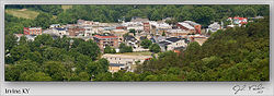
Irvine, Kentucky
Irvine, Kentucky | |
|---|---|
City | |
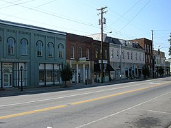 Downtown Irvine | |
 Location of Irvine in Estill County, Kentucky. | |
| Coordinates: 37°41′49″N 83°58′1″W / 37.69694°N 83.96694°WCoordinates: 37°41′49″N 83°58′1″W / 37.69694°N 83.96694°W | |
| Country | United States |
| State | Kentucky |
| County | Estill |
| Named for | William Irvine, an area pioneer |
| Area | |
| • Total | 1.47 sq mi (3.79 km2) |
| • Land | 1.39 sq mi (3.60 km2) |
| • Water | 0.07 sq mi (0.19 km2) |
| Elevation | 679 ft (207 m) |
| Population (2010) | |
| • Total | 2,715 |
| • Estimate (2019)[2] | 2,298 |
| • Density | 1,652.05/sq mi (637.96/km2) |
| Time zone | UTC-5 (Eastern (EST)) |
| • Summer (DST) | UTC-4 (EDT) |
| ZIP codes | 40336, 40472 |
| Area code(s) | 606 |
| FIPS code | 21-39646 |
| GNIS feature ID | 0512925 |

Irvine (locally /ˈɜːrvən, ˈɜːrvaɪn/) is a home rule-class city[3] in Estill County, Kentucky, in the United States. It is the seat of its county.[4] Its population was 2,715 at the time of the 2010 census.[5] It is located on the Kentucky River at the junction of Kentucky Route 52 and Kentucky Route 89. Irvine annually hosts the Mountain Mushroom Festival on the last weekend of April. Irvine and nearby Ravenna are known within Estill County as the "Twin Cities".[citation needed]
Geography[]

Irvine is located in the center of Estill County at 37°41′49″N 83°58′1″W / 37.69694°N 83.96694°W (37.696835, -83.966895).[6] The city limits are on the northeast side of the Kentucky River, and the city is bordered by Ravenna to the southeast. According to the United States Census Bureau, Irvine has a total area of 1.49 square miles (3.85 km2), of which 1.41 square miles (3.65 km2) is land and 0.077 square miles (0.20 km2), or 5.13%, is water.[5]
Kentucky Route 89 passes through Irvine as Main Street; Route 52 enters from the east as River Drive, then joins Route 89 to cross the Kentucky River. Route 89 leads north 27 miles (43 km) to Winchester and south 28 miles (45 km) to McKee, while Route 52 leads southeast 26 miles (42 km) to Beattyville and west 19 miles (31 km) to Richmond.
History[]
Gen. Green Clay established the town of Irvine on 20.5 acres (8.3 ha) of his land on January 28, 1812,[7] four years after Estill County was separated from Madison County. It was named for Col. ,[8] a pioneer settler of Madison County. The post office was established in 1813,[9] and the city was incorporated by the state legislature in 1849.[7]
On October 13, 1864, Irvine was sacked by Confederate guerrillas who razed its jail.
Even by Kentucky standards, Irvine remained small until the 1870s, when its population passed 300. Connection to the Louisville & Nashville Railroad's North Fork, as well as an early-20th century coal boom around the city, greatly increased the local population.
Demographics[]
| Historical population | |||
|---|---|---|---|
| Census | Pop. | %± | |
| 1830 | 91 | — | |
| 1860 | 234 | — | |
| 1870 | 224 | −4.3% | |
| 1900 | 260 | — | |
| 1910 | 272 | 4.6% | |
| 1920 | 2,705 | 894.5% | |
| 1930 | 3,640 | 34.6% | |
| 1940 | 3,631 | −0.2% | |
| 1950 | 3,259 | −10.2% | |
| 1960 | 2,955 | −9.3% | |
| 1970 | 2,918 | −1.3% | |
| 1980 | 2,889 | −1.0% | |
| 1990 | 2,836 | −1.8% | |
| 2000 | 2,843 | 0.2% | |
| 2010 | 2,715 | −4.5% | |
| 2019 (est.) | 2,298 | [2] | −15.4% |
| U.S. Decennial Census[10] | |||
As of the census[11] of 2000, there were 2,843 people, 1,259 households, and 793 families residing in the city. The population density was 1,871.7/sq mi (722.7/km2). There were 1,409 housing units at an average density of 927.6/sq mi (358.1/km2). The racial makeup of the city was 99.26% White, 0.04% African American, 0.21% Native American, 0.04% from other races, and 0.46% from two or more races. Hispanic or Latino of any race were 0.56% of the population.
There were 1,259 households, out of which 26.9% had children under the age of 18 living with them, 42.7% were married couples living together, 17.2% had a female householder with no husband present, and 37.0% were non-families. 33.7% of all households were made up of individuals, and 17.5% had someone living alone who was 65 years of age or older. The average household size was 2.22 and the average family size was 2.82.
22.9% of the population was under the age of 18, 8.0% from 18 to 24, 27.7% from 25 to 44, 23.0% from 45 to 64, and 18.5% who were 65 years of age or older. The median age was 39 years. For every 100 females, there were 83.9 males. For every 100 females age 18 and over, there were 77.2 males.
The median income for a household in the city was $20,286, and the median income for a family was $25,046. Males had a median income of $28,988 versus $17,194 for females. The per capita income for the city was $14,075. About 20.9% of families and 28.2% of the population were below the poverty line, including 25.4% of those under age 18 and 22.0% of those age 65 or over.
Economy[]
Major employers include Carhartt.[12] Mercy Health Partners operates Marcum and Wallace Memorial Hospital in Irvine.[13]
Education[]
Irvine has a lending library, the Estill County Public Library.[14]
Notable people[]
- Harry Dean Stanton (1926–2017), character actor
- Kevin Richardson, member of the Backstreet Boys
- Lee Rose, basketball coach
- , Dallas Cowboys Cheerleader [15]
References[]
- ^ "2019 U.S. Gazetteer Files". United States Census Bureau. Retrieved July 24, 2020.
- ^ Jump up to: a b "Population and Housing Unit Estimates". United States Census Bureau. May 24, 2020. Retrieved May 27, 2020.
- ^ "Summary and Reference Guide to House Bill 331 City Classification Reform" (PDF). Kentucky League of Cities. Retrieved December 30, 2014.
- ^ "Find a County". National Association of Counties. Archived from the original on 2011-05-31. Retrieved 2011-06-07.
- ^ Jump up to: a b "Geographic Identifiers: 2010 Demographic Profile Data (G001): Irvine city, Kentucky". American Factfinder. U.S. Census Bureau. Archived from the original on February 13, 2020. Retrieved February 1, 2016.
- ^ "US Gazetteer files: 2010, 2000, and 1990". United States Census Bureau. 2011-02-12. Retrieved 2011-04-23.
- ^ Jump up to: a b Commonwealth of Kentucky. Office of the Secretary of State. Land Office. "Irvine, Kentucky". Accessed 29 July 2013.
- ^ Gannett, Henry (1905). The Origin of Certain Place Names in the United States. Govt. Print. Off. pp. 166.
- ^ Rennick, Robert M. (1987). Kentucky Place Names. University Press of Kentucky . p. 150. ISBN 0813126312. Retrieved 28 April 2013.
- ^ "Census of Population and Housing". Census.gov. Retrieved June 4, 2015.
- ^ "U.S. Census website". United States Census Bureau. Retrieved 2008-01-31.
- ^ Irvine-Estill County Community Profile
- ^ About Marcum & Wallace Archived 2013-07-28 at the Wayback Machine
- ^ "Kentucky Public Library Directory". Kentucky Department for Libraries and Archives. Archived from the original on 11 January 2019. Retrieved 5 June 2019.
- ^ https://www.dallascowboys.com/cheerleaders/roster/kashara
External links[]
- Estill Development Alliance - Estill County Information
- Estill County Water District 1
- Mountain Mushroom Festival
| show Municipalities and communities of Estill County, Kentucky, United States |
|---|

| show Authority control |
|---|
- Cities in Kentucky
- Cities in Estill County, Kentucky
- County seats in Kentucky