Issyk-Kul
| Issyk-Kul | |
|---|---|
 Southern shore of Issyk-Kul, 2005 | |
 Issyk-Kul | |
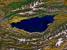 Issyk-Kul from space, September 1992 | |
| Coordinates | 42°25′N 77°15′E / 42.417°N 77.250°ECoordinates: 42°25′N 77°15′E / 42.417°N 77.250°E |
| Lake type | Ancient lake, Endorheic Mountain lake Monomictic |
| Primary inflows | Glaciers |
| Primary outflows | Evaporation |
| Catchment area | 15,844 square kilometres (6,117 sq mi) |
| Basin countries | Kyrgyzstan |
| Max. length | 178 kilometres (111 mi)[1] |
| Max. width | 60.1 kilometres (37.3 mi)[1] |
| Surface area | 6,236 square kilometres (2,408 sq mi)[1] |
| Average depth | 278.4 metres (913 ft)[1] |
| Max. depth | 668 metres (2,192 ft)[1][2] |
| Water volume | 1,738 cubic kilometres (417 cu mi)[3][2] |
| Residence time | ~330 years[2] |
| Salinity | 6g/L[1][2] |
| Shore length1 | 669 kilometres (416 mi)[1] |
| Surface elevation | 1,607 metres (5,272 ft)[1] |
| Settlements | Cholpon-Ata, Karakol |
| Official name | The Issyk-kul State Nature Reserve with the Issyk-kul Lake |
| Designated | 12 November 2002 |
| Reference no. | 1231[4] |
| 1 Shore length is not a well-defined measure. | |


Issyk-Kul (also Ysyk Köl, Issyk-Kol, Kyrgyz: Ысык-Көл, romanized: Ysyk Köl, [ɯsɯqkœl]; Russian: Иссык-Куль, Issyk-Kul) is an endorheic lake in the Northern Tian Shan mountains in Eastern Kyrgyzstan. It is the seventh deepest lake in the world, the tenth largest lake in the world by volume (though not in surface area) and the second largest saline lake after the Caspian Sea. Issyk-Kul means "warm lake" in the Kyrgyz language; although it is surrounded by snow-capped peaks, it never freezes.[5]
The lake is a Ramsar site of globally significant biodiversity[6] and forms part of the Issyk-Kul Biosphere Reserve.
Geography[]
Issyk-Kul Lake is 182 kilometres (113 mi) long, up to 60 kilometres (37 mi) wide and its area is 6,236 square kilometres (2,408 sq mi). It is the second-largest mountain lake in the world behind Lake Titicaca in South America. It is at an altitude of 1,607 metres (5,272 ft) and reaches 668 metres (2,192 ft) in depth.[7]
About 118 rivers and streams flow into the lake; the largest are the Jyrgalang and Tüp. It is fed by springs, including many hot springs and snow melt. The lake has no current outlet, but some hydrologists hypothesize[8] that the lake's water filters deep underground into the Chu River. The bottom of the lake contains the mineral monohydrocalcite: one of the few known lacustrine deposits.[9]
The lake's southern shore is dominated by the ruggedly beautiful Teskey Ala-Too Range of the Tian Shan mountains. The northern slopes of the range are long and send a considerable flow to Issyk-Kul. Numerous streams taking their rise at the slopes flow together into comparatively large rivers. They deeply dissect the range and flow in wide valleys. On exit from mountains the rivers form large alluvial cones. In eastern part of Issyk-Kul they flow into Jyrgalang river. The Kungey Alatau of the Tian Shan runs parallel to the north shore. The southern slopes of the Kungey Alatau are comparatively short. Therefore, the rivers rising on them are relatively small and do not have a chance to flow together to form larger hydrographic systems. As a result, they separately empty either into Issyk-Kul or into Tüp river flowing along the range. [10]
The lake water's salinity is approx. 0.6% – compared to 3.5% salinity of typical seawater – and, although the lake level is still currently some 8 metres (26 ft) higher than in medieval times, its level now drops by approximately 5 centimetres (2.0 in) per year due to water diversion.[11]
Administratively, the lake and the adjacent land are within Issyk-Kul Region of Kyrgyzstan.
Tourism[]
During the Soviet era, the lake became a popular vacation resort, with numerous sanitoria, boarding houses and vacation homes along its northern shore, many concentrated in and around the town of Cholpon-Ata. These fell on hard times after the break-up of the USSR, but now hotel complexes are being refurbished and simple private bed-and-breakfast rentals are being established for a new generation of health and leisure visitors.

The city of Karakol (formerly Przhevalsk, after the Russian explorer Przhevalsky, who died there) is the administrative seat of Issyk-Kul Region of Kyrgyzstan. It is near the east tip of the lake and is a good base for excursions into the surrounding area. Its small old core contains an impressive wooden mosque, built without metal nails by the Dungan people and a wooden Orthodox church that was used as a stable during Soviet times (see state atheism).
History[]
Issyk-Kul Lake was a stopover on the Silk Road, a land route for travelers from the Far East to Europe. The great Chinese Buddhist scholar-monk Xuanzang passed by this lake and noted the details in the classic travelogue Great Tang Records on the Western Regions in the 7th century. The lake was once owned by the Qing Dynasty of China and was ceded to Russia – along with the surrounding territory – after the Treaty of Tarbagatai. Many historians believe that the lake was the point of origin for the Black Death that plagued Europe and Asia during the early and mid-14th century.[12] The lake's status as a byway for travelers allowed the plague to spread across these continents via medieval merchants who unknowingly carried infested vermin along with them.

The lake level is some 8 metres (26 ft) higher than in medieval times. Divers have found the remains of submerged settlements in shallow areas around the lake. In December 2007, a report was released by a team of Kyrgyz historians, led by Vladimir Ploskikh, vice president of the Kyrgyz Academy of Sciences, that archaeologists have discovered the remains of a 2500-year-old advanced civilization at the bottom of the Lake. The data and artifacts obtained suggest that the ancient city was a metropolis in its time. The discovery consisted of formidable walls, some stretching for 500 metres (1,600 ft) and traces of a large city with an area of several square kilometres. Other findings included Scythian burial mounds eroded over the centuries by waves, and numerous well-preserved artifacts, including bronze battleaxes, arrowheads, self-sharpening daggers, objects discarded by smiths, casting molds, and money.
Articles identified as the world's oldest extant coins were found underwater, with gold wire rings used as small change and a large hexahedral goldpiece. Also found was a bronze cauldron with a level of craftsmanship that is today achieved by using an inert gas environment.[13][14][15]
In 1916 the monastery at Issyk-Kul was attacked by Kyrgyz rebels, and seven monks were killed.[16]
Environment[]
Specially protected areas[]
The first nature reserve in Kyrgyzstan, Issyk-Kul State Reserve was established in 1948 to protect unique nature landscapes and waterfowl at Issyk-Kul. In 1975, it was acknowledged as a Ramsar site. Biosphere Reserve Issyk-Kul covered by UNESCO World Network of Biosphere Reserves was established in year 2000 within the administrative borders of Issyk-Kul Region.[17]
Fish[]
The lake contains highly endemic fish biodiversity, and some of the species, including four endemics, are seriously endangered. In recent years catches of all species of fish have declined markedly, due to a combination of over-fishing, heavy predation by two of the introduced species (the Pike perch and the Rainbow trout), and the cessation of lake restocking with juvenile fish from hatcheries. At least four commercially targeted endemic fish species are sufficiently threatened to be included in the Red Book of the Kyrgyz Republic: Schmidt's dace (Leuciscus schmidti), Issyk-Kul dace (Leuciscus bergi), marinka (), and sheer or naked osman (Gymnodiptychus dybowskii). Seven other endemic species are almost certainly threatened as by-catch or are indirectly impacted by fishing activity and changes to the structure and balance of the lake's fish population.
Sevan trout, a fish endemic to Lake Sevan in Armenia, was introduced into Issyk-Kul in the 1970s. While this fish is an endangered species in its "home" lake, it has a much better chance to survive in Lake Issyk-Kul where it has ravaged the indigenous species.
Creation legend[]
In pre-Islamic legend, the king of the Ossounes had donkey's ears. He would hide them, and had his barbers killed to hide his secret. One barber yelled the secret into a well, but he did not cover the well afterwards. As a result, the well water rose and flooded the kingdom. The kingdom is today under the waters of Issyk-Kul. According to the legend, this is how the lake was formed. Other legends say that four drowned cities lie at the bottom of the lake. Substantial archaeological finds indicating the presence of an advanced civilization in ancient times have been made in shallow waters of the lake.[15]
[]
During the Soviet period, the Soviet Navy operated an extensive facility at the lake's east end, where submarine and torpedo technology was evaluated.[18] In March 2008, Kyrgyz newspapers reported that 866 hectares (2,140 acres) around the on the lake would be leased for an indefinite period to the Russian Navy, which is planning to establish new naval testing facilities as part of the 2007 bilateral Agreement on Friendship, Cooperation, Mutual Help, and Protection of Secret Materials. The Russian military will pay $4.5 million annually to lease the area.[19] India also plans to invest in the facility to test all types of torpedoes such as heavy weight torpedoes and those that have thermal navigation system. Another advantage that works for the testing center is that the torpedoes fired can also be recovered allowing scientists to make physical verification of a torpedo structure for further study. India is also planning to use the torpedo test facility to test the autonomous underwater vehicle being developed by NSTL. For this, India has proposed to engage local companies with know-how in torpedo technology to further co-develop the facility.[20]

Lakeside towns[]
Towns and some villages around the lake, listed clockwise from the lake's western tip:
- Balykchy (the railhead at the western end of the lake)
- Koshkol'
- Tamchy
- Cholpon-Ata (the capital of the north shore)
- Tyup
- Karakol (the provincial capital near the eastern end of the lake, formerly named Przhevalsk)
- Barskon
Notable inhabitants[]
- Tugelbay Sydykbekov, writer
See also[]
- Lake Ala-Kul
References[]
- ^ Jump up to: a b c d e f g h Savvaitova, K.; Petr, T. (December 1992), "Lake Issyk-Kul, Kirgizia", International Journal of Salt Lake Research, 1 (2): 21–46, doi:10.1007/BF02904361
- ^ Jump up to: a b c d Hofer, Markus; Peeters, Frank; Aeschbach-Hertig, Werner; Brennwald, Matthias; Holocher, Johannes; Livingstone, David M.; Romanovski, Vladimir; Kipfer, Rolf (11 July 2002), "Rapid deep-water renewal in Lake Issyk-Kul (Kyrgyzstan) indicated by transient tracers" (PDF), Limnology and Oceanography, 4 (47): 1210–1216, doi:10.4319/lo.2002.47.4.1210, archived from the original (PDF) on 4 March 2016
- ^ Kodayev, G.V. (1973), "Морфометрия озера Иссык-Куль" [Morphometry of Lake Issyk-Kul], News of the All-Union Geographic Society (Izvestiya VGO) (in Russian)
- ^ "The Issyk-kul State Nature Reserve with the Issyk-kul Lake". Ramsar Sites Information Service. Retrieved 25 April 2018.
- ^ Nihoul, Jacques C.J.; Zavialov, Peter O.; Micklin, Philip P. (2012). Dying and Dead Seas Climatic Versus Anthropic Causes. Springer Science+Business Media. p. 21. Retrieved 4 December 2015.
- ^ Ramsar Site RDB Code 2KG001
- ^ International Lake Environment Committee Foundation Archived 2005-09-06 at the Wayback Machine
- ^ V. V.Romanovsky, "Water level variations and water balance of Lake Issyk-Kul", in Jean Klerkx, Beishen Imanackunov (2002), p.52
- ^ Sapozhnikov, D. G.; A. I. Tsvetkov (1959). "[Precipitation of hydrous calcium carbonate on the bottom of Lake Issyk-Kul]". Doklady Akademii Nauk SSSR. 24: 131–133.
- ^ Gruche, P.A. (1940). Геологическая карта Средней Азии. Лист К-44-А. Юго-западная четверть (Пржевальск). Масштаб 1:500000 [Geological Map of Central Asia. Sheet K-44-A. South eastern Quarter (Przhevalsk). Scale 1:500000] (in Russian). Leningrad, Moscow: Committee for Geology at the Soviet of Peoples' Commissaries. Geological Service of Kirghiz SSR.
- ^ Lake Profile: Issyk-Kul (Isyk-Kul)
- ^ The Silk Route – Channel 4
- ^ ANI (2007-12-28). "Archaeologists discover remains of 2500-year-old advanced civilization in Russia". Yahoo! News. Archived from the original on 2008-01-01.
- ^ "Advanced Russian civilization found". The Times Of India. Archived from the original on December 31, 2007.
- ^ Jump up to: a b Lukashov, Nikolai. Ancient Civilization Discovered at the Bottom of Lake Issyk-Kul in the Kyrgyz Mountains. Ria Novosti. December 27, 2007. Accessed on: July 24, 2008.
- ^ Islam in the Russian Federation and the Post Soviet Republics: a Historical perspective by Spyros Plakoudas, p. 10
- ^ Specially protected nature areas in Kyrgyzstan. Archived 2010-03-24 at the Wayback Machine
- ^ Kommersant-Vlast, 'Vys Rossiya Armia', 2005
- ^ RFE/RL NEWSLINE 14 March 2008
- ^ India to develop state of the art torpedo testing centre in Kyrgyzstan. September 18, 2011. Times of India
External links[]
| Wikimedia Commons has media related to Issyk-Kul. |
- World Lake Database entry for Issyk-Kul Lake
- The Issyk-Kul Hollow at Natural Heritage Protection Fund
- Remains of ancient civilization discovered on the bottom of Issyk-Kul Lake
- Views of lake Issyk-Kul from Abasayyoh
- Jean Klerkx, Beishen Imanackunov (eds.): "Lake Issyk-Kul: Its Natural Environment". Springer, 2002. ISBN 1-4020-0900-3. (Searchable text on Google Books)
| show |
|---|
| show Authority control |
|---|
- Ancient lakes
- Archaeological sites in Kyrgyzstan
- Lakes of Kyrgyzstan
- Endorheic lakes of Asia
- Mountain lakes
- Issyk-Kul Region
- Biosphere reserves of Kyrgyzstan
- Ramsar sites in Kyrgyzstan
- Sites along the Silk Road
- Russian and Soviet Navy bases
- Tian Shan
- Weapons test sites