Joondalup
| Joondalup Perth, Western Australia | |||||||||||||||
|---|---|---|---|---|---|---|---|---|---|---|---|---|---|---|---|
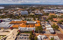 Aerial view of Joondalup | |||||||||||||||
 Joondalup | |||||||||||||||
| Coordinates | 31°44′42″S 115°45′58″E / 31.745°S 115.766°ECoordinates: 31°44′42″S 115°45′58″E / 31.745°S 115.766°E | ||||||||||||||
| Population | 9,090 (2016 census)[1] | ||||||||||||||
| • Density | 770/km2 (1,995/sq mi) | ||||||||||||||
| Established | 1980s | ||||||||||||||
| Postcode(s) | 6027 | ||||||||||||||
| Area | 11.8 km2 (4.6 sq mi) | ||||||||||||||
| Location | 26 km (16 mi) from Perth | ||||||||||||||
| LGA(s) | City of Joondalup | ||||||||||||||
| State electorate(s) | Joondalup | ||||||||||||||
| Federal Division(s) | Moore | ||||||||||||||
| |||||||||||||||

Joondalup (/ˈdʒuːndəlʌp/) is a suburb of Perth, Western Australia, approximately 26 kilometres (16 mi) north of Perth's central business district. It contains the central business district of the regional City of Joondalup and acts as the primary urban centre of Perth's outer northern suburbs.
History[]
During the latter part of the 1960s, the Metropolitan Regional Planning Authority developed the Corridor Plan for Perth which was published and adopted in 1970.[2] The plan called for the creation of five "sub-regional" retail centres (Fremantle, Joondalup, Midland, Armadale and Rockingham) which would form the commercial and economic focus of each "node", and take the retail burden away from the CBD.[3] The Corridor Plan was not endorsed by Parliament until 1973.[4][5]
In order to grow both the five "sub-regional" retail centres and these off-corridor regional shopping centres, a Retail Shopping Policy was developed by MRPA in 1976, and a Perth Metropolitan Region Retail Structure Plan was put in place to regulate the industry. This Plan was amended as new centres were required.[4] A review of the Corridor Plan in 1987 found that the sub-regional centres had failed to adequately compete against the regional shopping centres in the middle-distance suburbs.[4]
Most of the land in the area remained largely undeveloped until the 1960s, and Joondalup started to become the "city of the north" towards the late 1980s to the early 1990s when houses and businesses were established in the area. Joondalup is the key regional hub for the north of Perth, a status confirmed by the Western Australian State Government's new Directions 2031 strategy which names Joondalup town centre as one of two Primary Centres for the Perth metropolitan area.
The city is named after Lake Joondalup. The name Joondalup is a Noongar word, first recorded in 1837 and possibly meaning either "place of whiteness or glistening", or "place of a creature that can only move backwards".[6]
Geography[]
Joondalup is bounded by Burns Beach Road to the north, Mitchell Freeway to the west, Eddystone and Lakeside Drive to the south and Lake Joondalup to the east. Grand Boulevard and Joondalup Drive run through the centre of the suburb. Most of Joondalup consists of commercial and residential zones, although a suburban area exists between Moore Drive and Burns Beach Road near Currambine train station, and some small residential estates have been built along Lakeside Drive. The Yellagonga Regional Park and a small bushland corridor near the TAFE and university campuses are located in the east and south.[7]
Demographics[]
In the 2016 census, there were 9,090 people in Joondalup. 46.4% of people were born in Australia. The next most common countries of birth were England 15.3%, New Zealand 3.8%, South Africa 3.3%, Scotland 2.1% and India 2.0%. 73.5% of people spoke only English at home. Other languages spoken at home included Mandarin 3.0%, Arabic 1.9% and Afrikaans 1.3%. The most common responses for religion were No Religion 34.5%, Catholic 17.6% and Anglican 13.4%. The median age of the suburb was 34.[8]
Governance and law[]

Joondalup falls under the local government of the City of Joondalup and is represented by two councillors from the North Ward. The current councillors are Kerry Hollywood and Tom McLean.[9] The council chambers for the City of Joondalup are located in Joondalup's central business district. The complex includes Joondalup Library, which serves as the central library and local history centre for both the City of Joondalup and the City of Wanneroo local authorities. The Joondalup offices of the Australian Electoral Commission are located in the CBD. At state parliament level, Joondalup is represented in the Western Australian Legislative Assembly by a member from Joondalup electoral district. The current member is Emily Hamilton. In the Australian federal parliament, the suburb is part of the Division of Moore and is currently represented by member, Ian Goodenough.
The Western Australia Police Force has a police station based in Joondalup.[10] The WA Magistrates Court has a metropolitan court based in Joondalup that deals with both criminal offences and civil claims for debt or damages and non-offences.[11]
Culture[]
Retail[]
Joondalup's central business district, centred on Grand Boulevard, is largely a shopping and retail area lined with townhouses and apartments. Lakeside Joondalup Shopping City is located adjacent to the Joondalup railway station and backs onto Grand Boulevard.
Events and festivals[]
Joondalup is home to the Joondalup Festival, an annual event that takes place in the CBD featuring markets, music, fashion, street arts, fairground rides and street parades.[12] The festival is free-of-charge and attracts people from all over the Perth metropolitan area. Kaleidoscope Festival has also been held in the city since 2016, featuring various art and light installations. The festival attracted over 50,000 people in its inaugural year.[13]
Parks and beaches[]
The city has a number of parks including Central Park and Neil Hawkins Park in the Yellagonga Regional Park. The Neil Hawkins Park is home to many parrots (including the Australian ringneck), cockatoos and kangaroos. The park is located alongside Lake Joondalup and wetlands which stretches out between Burns Beach Road to the north and Ocean Reef Road to the south. These wetlands provide refuge for migratory birds. Joondalup's coastal front consists of Burns Beach in the north and Beaumaris Beach in Ocean Reef, running onto the Ocean Reef Boat Harbour in the south.
Sports[]

Joondalup is home to ECU Joondalup SC, Joondalup United FC and Sorrento FC who play in the National Premier Leagues which is Australia's second tier association football league. Sorrento FC is one of Joondalup's most successful clubs and their derbies with ECU Joondalup are always eagerly anticipated.
Arena Joondalup, (also known commercially as HBF Arena) located northwest of Lakeside Shopping Centre, is the home venue of West Perth Football Club and Wanneroo Basketball Association. The Arena also hosts music events and festivals during the year, as well as the Home and Lifestyle Expo, an annual exhibition held in late March to early April.
Furthermore, in the early 1990s with the addition of the Western Reds to the National Rugby League, the Joondalup Giants was established playing home games from Admiral Park in WARL completion.
Nightlife[]
Joondalup is a popular city for nightlife on weekends and Friday nights, with most of its pubs and nightclubs located in close proximity to each other in the CBD. The CBD contains two major nightclubs, Crush and Dusk, as well as four pubs around the city, The Old Bailey, the Grand Boulevard Tavern, The Sovereign Arms. Joondalup was granted the status of "tourism precinct" by the State Government in 2009, allowing extended retail trading hours.
Education[]
The Joondalup suburb is a major location for tertiary education in the northern suburbs and is known as the Joondalup Learning Precinct. The North Metropolitan TAFE has a campus in Joondalup providing state government education to meet the demands of students wanting to enter the workforce with up-to-date, industry-specific, practical skills. It was previously called the West Coast Institute of Training. Edith Cowan University has a major campus based in the suburb. It offers graduate and post graduate degrees on the campus that also includes, libraries, guilds, commercial shops, sporting facilities, and student housing. Situated in the same Joondalup Learning Precinct as ECU and the TAFE campuses is the West Australian Police Academy. The Western Australia Police's training academy was moved from Maylands to Joondalup and was officially opened on 15 February 2002.[14] The suburb also contains Joondalup Primary School and Lake Joondalup Baptist College.
Infrastructure[]

Health[]
Joondalup contains a major public hospital, Joondalup Health Campus, which serves as the main health facility for most of Perth's northern suburbs, as far north as Two Rocks. Joondalup Private Hospital is also incorporated into the public Health Campus, and both facilities are owned and operated by Ramsay Health Care.
Utilities[]
The Joondalup region's primary potable water supply comes from the nearby Gnangara Mound. The water is treated at the Wanneroo Groundwater Treatment Plant and, as in most of Western Australia, is managed by the Water Corporation.
Road transport[]
The suburb of Joondalup has three interchanges to the State Route 2, Mitchell Freeway on Hodges Drive, Shenton Avenue and Burns Beach Road. The other major route through the suburb is State Route 85, Joondalup Drive which leads to the Tonkin Highway and when completed, the Brand Highway and Great Northern Highway.
Public transport[]

The Joondalup train station and bus interchange is located next to and connected to Lakeside Joondalup Shopping City. The interchange is connected to the Transperth train network linking the area to the Perth CBD - a 25-minute journey - and to Butler railway station the terminus of the line. For a few months in early 1993, Joondalup was the terminus of the railway, and is part of the Joondalup Line.[15]
There are two types of bus services in the suburb. A free service called the CAT buses (routes 10 and 11) which travel a circular route around Joondalup's central area, ferrying passengers to Joondalup Health Campus, Edith Cowan University, North Metropolitan TAFE and Joondalup CBD, among other destinations. The residential part of the suburb to the north is serviced by the Transperth buses on routes 468 (Whitfords station to Joondalup station) and 473 (Kinross to Joondalup station).
References[]
- ^ Australian Bureau of Statistics (27 June 2017). "Joondalup (State Suburb)". 2016 Census QuickStats. Retrieved 23 July 2019.

- ^ Metropolitan Region Planning Authority (1970). The corridor plan for Perth. OCLC 521177.
- ^ Stephenson, Gordon (1975). The Design of central Perth: Some Problems and Possible Solutions. A Study made for the Perth Central Area Design Co-ordinating Committee. UWA. p. 44. ISBN 0-85564-107-X.
chap. 7 item 3 Regional shopping centres have been established in several suburbs. ..., and generally take the form of a pedestrian precinct surrounded by large car parks. [see also 7.2 & 7.4.]
- ^ Jump up to: a b c Ministry for Planning. "Evolution of the Spatial Distribution of Commercial Development". Commercial Land Use Survey 1997. Archived from the original on 6 October 2007. Retrieved 17 July 2007.
- ^ Gentilli, Joseph (1979). Western Landscapes. University of Western Australia. p. 459. ISBN 0-85564-155-X.
- ^ Western Australian Land Information Authority. "History of metropolitan suburb names – J". Retrieved 17 January 2007..
- ^ 2006 StreetSmart Perth street directory, Department of Land Information, Western Australia.
- ^ "2016 Census QuickStats: Joondalup". quickstats.censusdata.abs.gov.au. Retrieved 5 April 2021.
- ^ "Ward map – City of Joondalup". Retrieved 11 August 2020.
- ^ Police, Western Australia. "Your Local Police". Western Australia Police. Retrieved 11 August 2020.
- ^ Court, Magistrates. "Court Locations and Contacts". magistratescourt.wa.gov.au. Retrieved 11 August 2020.
- ^ "Tens of thousands turn out for 2018 Joondalup Festival". Community News Group. 29 March 2018. Retrieved 29 January 2019.
- ^ "Kaleidoscope attracts more than 50,000 to inaugural event". Community News Group. 17 November 2016. Retrieved 29 January 2019.
- ^ "Western Australia Police Academy". Western Australia Police. Retrieved 11 August 2020.
- ^ History of Stations on the Clarkson Train Line Right Track
External links[]
| Wikimedia Commons has media related to Joondalup, Western Australia. |
- City of Joondalup website
- West Perth Football Club Official Website
- Joondalup City Football Club
- Joondalup Audio Visual & Events Website
| Authority control |
|
|---|
- Suburbs of Perth, Western Australia
- Joondalup
- Cities in Western Australia
- City of Joondalup