Křtiny
Křtiny | |
|---|---|
 | |
 Flag  Coat of arms | |
 Křtiny Location in the Czech Republic | |
| Coordinates: 49°17′49″N 16°44′39″E / 49.29694°N 16.74417°ECoordinates: 49°17′49″N 16°44′39″E / 49.29694°N 16.74417°E | |
| Country | |
| Region | South Moravian |
| District | Blansko |
| First mentioned | 1237 |
| Government | |
| Area | |
| • Total | 11.17 km2 (4.31 sq mi) |
| Elevation | 417 m (1,368 ft) |
| Population (2020-01-01[1]) | |
| • Total | 832 |
| • Density | 74/km2 (190/sq mi) |
| Time zone | UTC+1 (CET) |
| • Summer (DST) | UTC+2 (CEST) |
| Postal code | 679 05 |
| Website | www |

Křtiny is a market town in Blansko District in the South Moravian Region of the Czech Republic. It has about 800 inhabitants. It lies on boundary of the Moravian Karst nature reserve.
Sights[]
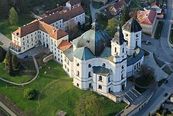
The town is an old Marian pilgrimage site (administered by the Premonstratensians) and is dominated by a Baroque pilgrim complex; the original project by Jan Santini Aichel was modified during construction and was not fully completed. It comprises the Church of the Name of the Virgin Mary (houses a Gothic statue of the Virgin Mary), St. Anne Chapel, Provost Residence and other buildings.
Close to Křtiny is karst show Výpustek Cave, ex secret army cave shelter.
References[]
- ^ "Population of Municipalities – 1 January 2020". Czech Statistical Office. 2020-04-30.
| show Authority control |
|---|
This South Moravian Region location article is a stub. You can help Wikipedia by . |
Categories:
- Market towns in the Czech Republic
- Populated places in Blansko District
- South Moravian Region geography stubs