Kaikōura
Kaikōura | |
|---|---|
 Town of Kaikōura as seen from the peninsula | |
 | |
| Coordinates: 42°24′S 173°41′E / 42.40°S 173.68°ECoordinates: 42°24′S 173°41′E / 42.40°S 173.68°E | |
| Country | New Zealand |
| Region | Canterbury |
| Territorial authority | Kaikōura District |
| Government | |
| • Mayor | Craig Mackle |
| • Deputy Mayor | Julie Howden |
| Area | |
| • Urban | 9.25 km2 (3.57 sq mi) |
| • District | 2,046.81 km2 (790.28 sq mi) |
| Population (June 2021)[1] | |
| • Urban | 2,420 |
| • Urban density | 260/km2 (680/sq mi) |
| • District | 4,260 |
| • District density | 2.1/km2 (5.4/sq mi) |
| District Postcode(s) | |
| City Postcode | 7300 |
| Website | www |
Kaikōura (/kaɪˈkɔːrə/) is a town on the east coast of the South Island of New Zealand. It is located on State Highway 1, 180 km north of Christchurch. The town has an estimated permanent resident population of 2,420 (as of June 2021).[1]
The town is the governmental seat of the territorial authority of the Kaikōura District, which is politically a part of the Canterbury region.[2] Kaikōura was the first local authority in the Southern Hemisphere to achieve recognition by the EarthCheck Community Standard.[3]
The infrastructure of Kaikōura was heavily damaged in the 2016 Kaikōura earthquake, with one of the two deaths near the town. The bay and surrounding region were uplifted by as much as 2 metres (6 ft 7 in).
History[]
Early Māori history[]
Māori have long been resident in Kaikōura and archeological evidence of moa bones suggesting that they hunted moa there. After the moa numbers declined, Kaikōura was still an attractive place to live with its abundance of sea food. Ngāi Tahu had been resident in the Kaikoura area since at least 1670.[4] Numerous pā sites are located around Kaikōura. The numbers vary between 14 and 40.[5][6]
Captain James Cook saw Kaikōura in 1770 but did not land there. He reported seeing four double hulled canoes approaching HMS Endeavour containing 57 Māori.[7][8]
In 1827 or 1828, Kaikōura was the site of a battle between the Ngāti Toa (led by Te Rauparaha) and Ngāi Tahu. Several hundred Ngāi Tahu were killed or captured.[7] Ngāi Tahu were surprised by the Ngati Toa raiding party as they were expecting a visit from Ngāti Kahungunu with whom they were friends.[4]
Whaling stations[]
A whaling station was first established by Robert Fyffe in 1842 at Kaikōura. The Fyffe family was the first European family to settle in Kaikōura. John Guard and his family joined Fyffe sometime between 1844 and 1846. 40 men were employed at the whaling station initially. In 1845, he purchased a second whaling station at South Bay. This second whaling station (Fyffe's Village) became the commercial centre of Kaikōura until 1867. Fyffe diversified into shipping and farming due to the decline in whale numbers.[9] The Marlborough Express newspaper commented in 1866 that "whales seemed to have abandoned coming to Kaikōura".[8] The whaling stations continued until 1922.[7]
Mt. Fyffe owes its name to the Fyffe family. The cottage that the Fyffe family lived in, built in 1842, still stands, and is now a tourist attraction operated by Heritage New Zealand. The construction of the cottage is unusual in that the supporting foundations of the house are made of whalebone.[10]
European settlement[]
The New Zealand government purchased land north of Kaikōura from Ngati Toa in 1847. This was challenged by Ngāi Tahu who said that Ngati Toa had no right to sell land that did not belong to them. In 1857, the New Zealand Government made an offer for land between the Ashley and Waiau Uwha rivers for 200 pounds which was signed by Ngāi Tahu. Other land deals were completed in the area leaving small reserves for local Māori. These reserves were reduced after 1900 when the New Zealand government compulsorily acquired further land for the proposed railway and "scenic" purposes.[4]
From the 1850s, land that had been acquired was sold to European settlers who most often started sheep farms in the area. Many small blocks were sold around the Kaikōura peninsula and in the 1870s roads and bridges were built. A small wharf was completed in 1863. The Inland Kaikōura Road to Rotherham was completed by 1888. The road that became state highway 1 was started in the 1890s across the Hundalee Hills with bridges across the rivers completed in 1914.[4]
A total of 59 Norfolk pines were planted from 1900 along the Esplanade. These now have "protected trees" status from the Kaikōura District Council.[5]
20th century[]
The population increased as a result of the extensive works required to built the railway in 1935. In December 1945, the Christchurch to Picton railway line was officially opened at Kaikōura. 5000 people came out to celebrate the occasion.[11] The population fell slightly after the railway was completed.[4]
Between 1945 and 1960, over-fishing led to a decline in the crayfish numbers.[4]
In 1962 the roll-on/roll-off car ferry between Wellington and Picton brought more visitors to Kaikōura.[11][12] There was only one motel (with 40 beds) prior to 1962.[4]
There are reports that between 1963 and 1964, 248 sperm whales in Kaikoura waters were killed during the last of the whaling activity in New Zealand.[8]
Kaikōura struggled economically during the 1970s. In 1975 there were 304 motel beds and a further 500 camp ground beds and hotel beds. The Marlborough Regional Development Council noted that there was investment in accommodation but not in tourist attractions at this time.[4]
By 1975 the decline in crayfish numbers had extended to other fish species. In 1975 there were 97 registered fishing vessels operating out of Kaikoura.[4]
The restructuring of the economy following the election of the Labour government in 1984 also affected Kaikōura adversely. Farm incomes dropped. Public sector employment was affected badly. There were 170 jobs lost in a town of 3000.[4]
In 1985 a group of local Kaikoura people established a tourist centre, and began promoting Kaikōura as a tourist destination. The focus at that stage was on the walking opportunities and the scenery.[4]
Whale-watching was established as a tourist venture in Kaikōura in 1987. Local Māori leaders were concerned about local unemployment, and mortgaged their houses to buy a 6.7 metres (22 ft) boat to start up a whale watching business to see the local sperm whales. In the first year of business, 3000 tourists took the opportunity to see whales. This has greatly expanded to more than 100,000 per annum.[13][14][8]
2016 Kaikōura earthquake[]
On 14 November 2016, a 7.8-magnitude earthquake struck the South Island just after midnight. It left two people dead (one near the town and one in the adjacent Hurunui District) and triggered a small tsunami. One thousand tourists and hundreds of residents were stranded in Kaikōura after the earthquake cut off train and vehicle access.[15][16] New Zealand Air Force helicopters ferried many people out of Kaikoura initially[17] with the New Zealand navy sending HMNZS Canterbury to ferry many hundreds of tourists out.[18]
1700 construction workers completed two million man hours to repair the quake-damaged route along State Highway 1 after the 2016 Kaikōura earthquake. It reopened on 15 December 2017.[19] The repairs included fixing almost 200 kilometres (120 mi) of damaged road and a similar length of railway line. The repairs cost NZ$1.1 billion.[20]
The rebuild after the 2016 earthquake had replaced or upgraded many of Kaikoura District Council's assets. These included replacing the oldest water mains built in the 1920s and many roads. This has left Kaikoura better placed financially in 2021 than many councils as they do not have to replace these in the next 30 years as part of their long term planning.[21]
Geography[]

The stretch of coastline stretching roughly between the mouths of the Conway and Waiau Toa / Clarence Rivers is generally known as the Kaikōura coast. This coast is unusual for the South Island east coast, as there is very little coastal plain, with the Seaward Kaikōura Range, a branch of the Southern Alps / Kā Tiritiri o te Moana, rising straight from the ocean.
The town of Kaikōura has the Seaward Kaikōuras as a backdrop. One of the walking tracks for visitors is the Mt. Fyffe track, which winds up Mt. Fyffe, and gives a panoramic view of the Kaikōura peninsula from the summit.
The Kaikōura Peninsula extends into the sea south of the town, and the resulting upwelling currents bring an abundance of marine life from the depths of the nearby Hikurangi Trench. The town owes its origin to this effect, since it developed as a centre for the whaling industry. The name Kaikōura means 'meal of crayfish' (kai – food/meal, kōura – crayfish)[22] and the crayfish industry still plays a role in the economy of the region. However Kaikōura has now become a popular tourist destination, mainly for whale watching (the sperm whale watching is well developed) and swimming with or near dolphins.
Climate[]
| Climate data for Kaikōura | |||||||||||||
|---|---|---|---|---|---|---|---|---|---|---|---|---|---|
| Month | Jan | Feb | Mar | Apr | May | Jun | Jul | Aug | Sep | Oct | Nov | Dec | Year |
| Average high °C (°F) | 20.6 (69.1) |
20 (68) |
18.8 (65.8) |
16.6 (61.9) |
14.1 (57.4) |
11.6 (52.9) |
10.9 (51.6) |
11.5 (52.7) |
13.6 (56.5) |
15.3 (59.5) |
16.9 (62.4) |
19.1 (66.4) |
15.7 (60.3) |
| Average low °C (°F) | 12.8 (55.0) |
12.8 (55.0) |
11.9 (53.4) |
9.9 (49.8) |
7.7 (45.9) |
5.8 (42.4) |
5.1 (41.2) |
5.6 (42.1) |
6.7 (44.1) |
8.2 (46.8) |
9.8 (49.6) |
11.7 (53.1) |
9 (48) |
| Average precipitation mm (inches) | 47 (1.9) |
59 (2.3) |
92 (3.6) |
81 (3.2) |
71 (2.8) |
75 (3.0) |
80 (3.1) |
78 (3.1) |
70 (2.8) |
74 (2.9) |
60 (2.4) |
54 (2.1) |
844 (33.2) |
| Source: NIWA Climate Data[23] | |||||||||||||
Governance[]
Local governance for Kaikōura is provided by the Kaikōura District Council (Ko te kaunihera ā rohe o Kaikōura). The council consists of a mayor and seven councillors. Elections for positions on the council are held every three years in conjunction with nationwide local elections.[24]
Demographics[]
Kaikōura is defined by Statistics New Zealand as a small urban area and covers 9.25 km2 (3.57 sq mi).[25] It had an estimated population of 2,420 as of June 2021,[1] with a population density of 262 people per km2.
| Year | Pop. | ±% p.a. |
|---|---|---|
| 2006 | 2,202 | — |
| 2013 | 2,010 | −1.29% |
| 2018 | 2,223 | +2.03% |
| Source: [26] | ||
Kaikōura had a population of 2,223 at the 2018 New Zealand census, an increase of 213 people (10.6%) since the 2013 census, and an increase of 21 people (1.0%) since the 2006 census. There were 873 households. There were 1,107 males and 1,116 females, giving a sex ratio of 0.99 males per female. The median age was 47.7 years (compared with 37.4 years nationally), with 318 people (14.3%) aged under 15 years, 354 (15.9%) aged 15 to 29, 981 (44.1%) aged 30 to 64, and 573 (25.8%) aged 65 or older.
Ethnicities were 83.3% European/Pākehā, 19.6% Māori, 0.8% Pacific peoples, 5.0% Asian, and 3.1% other ethnicities (totals add to more than 100% since people could identify with multiple ethnicities).
The proportion of people born overseas was 18.2%, compared with 27.1% nationally.
Although some people objected to giving their religion, 48.2% had no religion, 40.6% were Christian, 0.3% were Hindu, 0.3% were Muslim, 0.5% were Buddhist and 3.4% had other religions.
Of those at least 15 years old, 231 (12.1%) people had a bachelor or higher degree, and 447 (23.5%) people had no formal qualifications. The median income was $30,200, compared with $31,800 nationally. The employment status of those at least 15 was that 969 (50.9%) people were employed full-time, 315 (16.5%) were part-time, and 30 (1.6%) were unemployed.[26]
Culture[]
In Māori mythology, Kaikōura Peninsula (Taumanu o te Waka o Māui) was the seat where Māui sat when he fished the North Island (Te Ika a Maāi) up from the depths of the sea.[27]
The tangata whenua of Kaikōura and all of the Kaikōura District are Te Runanga o Ngāi Tahu, and they hold customary tribal authority over this entire area (rohe).[28] Takahanga Marae, a marae (tribal meeting ground) of Ngāi Tahu and its Te Rūnanga o Kaikōura branch, is located in Kaikōura. The current marae building was opened in 2001. It includes the Maru Kaitatea wharenui (meeting house).[29][30] Cliff Whiting was one of many Māori and Pākehā artists who contributed carving and artworks for the wharenui.[31]
Wildlife and conservation[]
The Kaikōura canyon is a submarine canyon located southwest of the Kaikōura Peninsula. It is a southern branch of the Hikurangi Trench that extends northwards up the New Zealand east coast. The canyon has been described as a "bio-diversity hotspot", and upwelling of currents from the deep ocean provide feeding grounds for a diverse range of seabirds and marine mammals along the Kaikōura coast.[32][33] The Kaikōura (Te Tai o Marokura) Marine Management Act[34] came into effect in 2014, establishing the Kaikōura marine management area. This included a new marine reserve, sanctuaries and protections for whales and fur seals, and established new fishing regulations. It also recognised Taiapure (traditional Māori fishing grounds which include areas of special cultural or spiritual significance).[35]
Marine mammals[]
A wide variety of marine mammals can be seen in the Kaikōura region, including whales, dolphins, and seals.[36] The Marine Mammals Protection Act 1978 provides legal protection for these animals, and regulations set conditions that govern human behaviour in the vicinity of marine mammals. Permits are required for commercial tourist operations associated with marine mammals.[37]
Whales[]
Whale watching is a popular tourist attraction for Kaikōura, and is an important contributor to the local economy.[38] Sperm whales can be observed all year, typically around 23 km offshore, but sometimes closer to shore.[39] Humpback whales are often seen in June and July during their winter migration, and orca can be seen from December to March.[40]
Dolphins[]
Several species of dolphin can be seen in the waters off Kaikōura, including Dusky dolphins, and the endangered Hector's dolphin.[36]
New Zealand fur seals[]
There is a large and readily observed colony of southern fur seals at the eastern edge of the town. At low tide, better viewing of the seals can be had as the ocean gives way to a rocky base which is easily navigable by foot for quite some distance.
Seabirds[]
New Zealand has an usually high diversity of shags, penguins, petrels and albatross species, leading to claims that the country is the "seabird capital of the world". [41] Some of these seabird species are in significant decline, and many are critically endangered.[42] Notable seabirds that are seen off Kaikōura include:[43][44][33]
- fourteen species of albatross: Wandering, Antipodean, Northern royal, Southern royal, Black-browed, Campbell, White-capped, Salvin's, Chatham, Buller's, Atlantic ocean yellow-nosed, Indian ocean yellow-nosed, Light-mantled, Sooty
- ten species of petrel: Cook's, Grey-faced, Cape, Black, White-chinned, Westland, Grey, White-headed, Mottled, Soft-plumaged
- seven species of shearwater: Buller's, Sooty, Hutton's, Fluttering, Short-tailed, Flesh-footed, Pink-footed
- four species of skua: Arctic, Pomarine, Long-tailed, Brown
- four species of storm petrel: White-faced, Wilson's, Grey-backed, Black-bellied
- four species of penguin:Little, Yellow-eyed, Erect-crested, Chinstrap
- two species of giant petrel: Southern Giant Petrel, Northern Giant Petrel
Other notable seabirds observed off Kaikōura include: Antarctic fulmar, Fairy Prion, Grey Phalarope, Black-billed gull, Arctic tern, Black-fronted tern and Common diving petrel. Also regularly seen are Pied shags, Little shag, Spotted shag, Australasian gannet, Southern black-backed gull, Red-billed gull, White-fronted tern.[45]
From a local conservation perspective, particularly notable seabirds in the Kaikōura region include the Hutton's shearwater, the Red-billed gull, and the Little penguin.
Hutton's shearwater[]

The Hutton's shearwater (Puffinus huttoni) or Kaikōura tītī is an endangered seabird in the family Procellariidae. It is found in waters around Australia and New Zealand but it only breeds in the Seaward Kaikōura Range in New Zealand. It is the only seabird in the world that breeds in an alpine environment. Nests have been found at elevations from 1200 to 1800 metres. The Kowhai Valley and Shearwater Stream Important Bird Area contains the only two remaining alpine breeding colonies. An artificial colony was established in a protected area on the Kaikōura peninsula as a conservation measure, after six other colonies were wiped out by feral pigs.[46][47] The birds fly at night, but can become disoriented by bright lights. Fledglings are particularly vulnerable, and can crash-land on roads in the town. They are usually unable to take off again, making them vulnerable to being run over by vehicles or succumbing to predation by dogs or cats. Conservation organizations in Kaikōura rescue stranded birds for later release, and advocate for reduced lighting.[48]
Red-billed gull[]

The Red-billed gull also known as tarāpunga, is native to New Zealand. The Kaikōura peninsula has one of the three largest breeding colonies of these gulls, but the local population is in significant decline.[49][50] In contrast, there has been an increase in the population of Red-billed gulls at the breeding colony at Otago Peninsula, where there is control of mammalian predators.[51]
Little penguin[]
The Little penguin or kororā is found along the Kaikōura coastline. These birds are vulnerable to becoming entangled in fishing nets, and while on land are vulnerable to vehicle impact and predation by rats and domestic dogs. In a recent survey of 75 km of Kaikōura coastline, the only breeding colony located was in fragmented areas around the southern part of the Kaikōura peninsula.[52]
Shorebirds[]
Banded dotterel[]
The Double-banded plover, known in New Zealand as the banded dotterel or pohowera, is a species of bird in the plover family that nests on stony beaches around the Kaikōura peninsula and South Bay. The species is listed as Nationally Vulnerable.[53] Breeding success of banded dotterels at Kaikōura has been severely affected by predation from cats.[54] A community-driven action plan is being developed to protect the habitat of nesting shorebirds at South Bay, with support from Environment Canterbury, Kaikōura District Council, University of Canterbury and Te Rūnanga o Kaikōura.[55]
Hikurangi Marine Reserve[]
The Hikurangi Marine Reserve is a marine reserve off the Kaikōura coast, covering an area of 10,416 hectares (25,740 acres) south of the township, and including part of the Kaikōura canyon. The reserve was established in 2014, and is the largest and deepest marine reserve adjacent to any of New Zealand's three main islands. No fishing, harvesting or mining is allowed in the reserve.[56][57][36]
Kaikōura whale sanctuary[]
The Kaikōura (Te Tai o Marokura) Marine Management Act 2014 established the Te Rohe o Te Whānau Puha Whale Sanctuary covering 4,686 square kilometres (1,809 sq mi), and extending 45 kilometres (28 mi) north and south of the Kaikoura peninsula and 56 kilometres (35 mi) out to sea, to provide additional protection for marine mammals in this area.[58][59]
Dark sky reserve[]
A new initiative has been launched to create a dark sky reserve in the Kaikōura District. This could reduce the problems that lighting causes for Hutton's shearwaters.[60] The Kaikōura District Council is planning for new streetlighting that will reduce the risk to the birds.[61][62]
Economy[]
In 2020, the GDP of the Kaikōura District was $232 million, with an annual growth for the region of 1.6%.[63] Tourism contributed $57 million to total GDP in Kaikoura District in 2020, and was the top overall category, contributing 24.8% of district GDP.[64]
Infrastructure[]
Hospital[]
Funding was announced in 2013 to rebuild the 100 year old Kaikoura Hospital.[65] It was completed in April 2016. The new building provides space for general practice, physiotherapy, dental, optometry as well as maternity, radiology and medical/trauma stabilisation and resuscitation facilities.[66] It cost $13.4 million to complete.[67]
Kaikoura Civic Centre[]

The Kaikōura Civic Centre was completed in 2016. It has a distinctive large "cray pot" on the outside of the building[68] which represents Kaikoura's connection to the sea.[69] It contains offices for the Kaikoura District Council, Kaikoura Library and Kaikoura Museum. A third floor was approved by the Kaikōura District Council in 2011 and the cost rose which led to complaints from rate payers and submissions to the Long Term Plan in 2012 requesting restraint in spending.[70][71][72] Long term, finances for the Kaikōura District Council have been suggested to be tenuous.[73]
Hotel[]
A $35 million 4.5 star hotel was due to open in September 2021, but work was delayed due to the loss of international tourists because of the Covid-19 virus. It is expected to have 118 bedrooms and provide economic stimulus to Kaikōura.[74][75]
Transport[]
Road transport[]
The town is on State Highway 1.
Air[]
Kaikōura also has a small sealed airstrip located 6 km south of the main centre. Kaikoura Airport is mainly used for whale spotting tourist flights but it can also be used by small private and charter flights. It previously had return flights to Wellington and Christchurch operated by Sounds Air. A new service to Wellington has since been started with Air Kaikoura.
Rail[]
Kaikōura is served by the Main North Line, the northern section of the South Island Main Trunk Railway. The line opened north of Kaikōura on 13 March 1944, while the line south of the town opened on 15 December 1945, the latter completing the full line Christchurch to Picton.[76]
Kaikōura is served by the Coastal Pacific long-distance passenger train, formerly called the TranzCoastal, which connects the town with Christchurch to the south, Picton and the Cook Strait ferries to the north. Kaikoura Station was the last station in New Zealand to have a refreshment room for passengers, which closed in 1988 when the Coastal Pacific Express (former name for the TranzCoastal) introduced on-board refreshments.[77]
Freight trains also pass through the town, mainly carrying freight between the marshalling yards at Middleton in Christchurch and the Interislander rail ferries at Picton.
The Main North Line (Picton to Christchurch, passing through Kaikōura) suffered damage in the November 2016 earthquake and was closed for repairs, re-opening to freight traffic on 15 September 2017. The Coastal Pacific was expected to resume running once all repairs had been completed in mid 2018.[78]
Education[]
The Kaikoura District has one secondary school, Kaikoura High School, and four primary schools: Hapuku School, Kaikoura Primary School, Kaikoura Suburban School and St Joseph's School.
Media[]
Newspapers[]
The main newspapers for Kaikōura are the Wednesday weekly and Monday to Friday late morning daily The Marlborough Express. The early morning Monday-Saturday Christchurch based daily The Press is also available. These papers are all owned by Fairfax New Zealand
Radio[]
Kaikōura has three locally transmitted radio stations on FM. These are More FM Marlborough (formerly Sounds FM) broadcast from Blenheim during the day and Auckland at night, which is a locally broadcast Kaikōura station, and Tahu FM broadcast from Christchurch. Non local transmissions of the following stations can be received: The Breeze (Wellington AM/FM), Radio New Zealand National (Wellington AM/FM), ZM (Wellington and Christchurch FM), Radio Hauraki (Christchurch).
Amenities[]
Cinema[]
Movies are shown at the Mayfair cinema (opened 1935), located on the Esplanade, and historically known for its carbon arc movie projector. In November 2013 the cinema went digital. It closed after the earthquake and reopened in November 2020.[79] As well as two movie screens, it has space for art exhibitions.[75]
Swimming pool[]
The Kaikōura swimming pool on the Esplanade was badly damaged in the 2016 earthquake, leaving Kaikōura without a public pool for five years.[80] A charitable trust was established and fundraising occurred to raise funds to build a replacement pool.[81]
The Kaikōura Aquatic Centre is planned to open in November 2021.[82] It includes a 25m x 12m lap pool, a smaller pool for learners and a toddler pool. Funding of $3.7 million has been raised for the build with the Kaikōura District Council contributing $1million, COVID Recovery Fund contributing $1 million and the Kaikōura Community Op Shop contributing $100,000.[83]
Horse racing[]
The Kaikōura race course is located on Bay Parade at South Bay and is administered by the Kaikōura Trotting Club. The club was first established in 1914 with the first Kaikōura Trotting Cup won by a horse called Kintail owned by Albert Edgar and trained by Billie Honeybone.[84] In 2021, the Kaikōura Trotting Cup weekend, normally held in early November was transferred to Addington Raceway in Christchurch due to Covid-19 restrictions.[85]
Golf course[]
The Kaikōura golf club was established in 1911 with 39 members joining during the first season. The first nine hole course was located at the South Bay Domain. In 1935, The course moved to a new 9 hole course with a club house near the Kowhai River. In 1958 three extra holes were added. and in 1960 a further three holes were added. In 1963 the course was extended again to 18 holes.[86] The Koura Bay golf resort just to the north of Kaikōura has a nine hole golf course. [87]
Gallery[]
- Kaikōura

Seaward Kaikōura Range from Kaikōura town
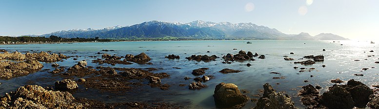
The Seaward Kaikōura mountain range from Kaikōura
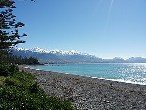
View of a beach and Seaward Kaikōura Range from Kaikōura
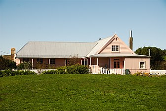
Fyffe House

Whale watching vessel
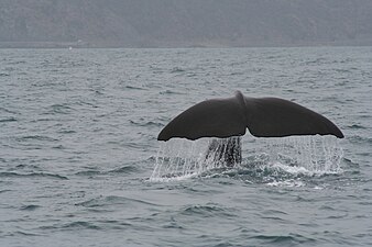
A sperm whale seen from on a whale-watching tour boat off Kaikōura

A seal colony on Kaikōura peninsula

A fur seal on the beach at Kaikōura


References[]
- ^ a b c "Population estimate tables - NZ.Stat". Statistics New Zealand. Retrieved 22 October 2021.
- ^ "Archived copy" (PDF). Archived from the original (PDF) on 8 February 2013. Retrieved 12 December 2012.CS1 maint: archived copy as title (link)
- ^ "Green Globe". Kaikoura District Council. Archived from the original on 21 March 2008. Retrieved 14 March 2008.
- ^ a b c d e f g h i j k McAloon, Jim; Simmons, David; Fairweather, John (1998). "Kaikoura: Historical Background" (PDF). Retrieved 3 April 2021.
- ^ a b "Kaikoura District Plan – 14/12/2010" (PDF).
- ^ Solomon, R (2014). "An overview of sensitive areas in Kaikoura in response to an application for a global Archaeological Authority by Chorus Ltd" (PDF).
- ^ a b c "History of Kaikoura – Lonely Planet Travel Information". www.lonelyplanet.com. Retrieved 3 April 2021.
- ^ a b c d "The town that whales built". New Zealand Geographic. Retrieved 3 April 2021.
- ^ Grady, Don. "Alexander Robert Fyffe". Dictionary of New Zealand Biography. Ministry for Culture and Heritage. Retrieved 6 April 2021.
- ^ "Fyffe House at the New Zealand Historic Places Trust". Archived from the original on 1 April 2008. Retrieved 18 May 2008.
- ^ a b "Kaikoura | NZHistory, New Zealand history online". nzhistory.govt.nz. Retrieved 3 April 2021.
- ^ "Kaikōura coast". teara.govt.nz. New Zealand Ministry for Culture and Heritage Te Manatu. Retrieved 3 April 2021.
- ^ "Whale Watch Kaikoura Our Story" (PDF). Retrieved 3 April 2021.
- ^ "NZ eco-tourism: Whale Watch Kaikoura". TNZ Media. Retrieved 3 April 2021.
- ^ "Hundreds of tourists stranded by New Zealand quake rescued by helicopter – World – CBC News". Cbc.ca. Retrieved 29 March 2017.
- ^ "Live updates following Monday's 7.8 earthquake: A picture of devastation". The New Zealand Herald. 16 November 2016. ISSN 1170-0777. Retrieved 17 November 2016.
- ^ "New Zealand earthquake: Kaikoura evacuations under way". BBC News. 15 November 2016. Retrieved 3 April 2021.
- ^ "Largest navy ship leaves Auckland to assist with earthquake rescue". Stuff. 15 November 2016. Retrieved 3 April 2021.
- ^ "State Highway 1 rebuild along Kaikōura coast two-thirds complete". Stuff. 20 December 2018. Retrieved 3 April 2021.
- ^ "Kaikōura road and rail rebuild up against fantastic feats of engineering". Stuff. 18 September 2018. Retrieved 3 April 2021.
- ^ "Kaikoura infrastructure in good shape – courtesy of earthquake rebuild". Stuff. 8 April 2021. Retrieved 8 April 2021.
- ^ "1000 Māori place names". New Zealand Ministry for Culture and Heritage. 6 August 2019.
- ^ "Climate Data". NIWA. May 2011. Retrieved 2 November 2007.
- ^ "Mayor and Councillors". Kaikoura District Council. Retrieved 30 September 2021.
- ^ "ArcGIS Web Application". statsnz.maps.arcgis.com. Retrieved 24 August 2021.
- ^ a b "Statistical area 1 dataset for 2018 Census". Statistics New Zealand. March 2020. Kaikōura (308900). 2018 Census place summary: Kaikōura
- ^ Royal, Te Ahukaramū Charles (12 June 2006). "Whenua – how the land was shaped – The North and South Islands". Te Ara – the Encyclopedia of New Zealand. Retrieved 21 September 2021.
- ^ "Tangata Whenua Values" (PDF). Kaikoura District Council. 1 January 2007. Retrieved 21 September 2021.
- ^ "Te Kāhui Māngai directory". tkm.govt.nz. Te Puni Kōkiri.
- ^ "Māori Maps". maorimaps.com. Te Potiki National Trust.
- ^ Graham, Brett (22 October 2014). "Whakairo – Māori carving: Page 7. Carving in urban environments". Te Ara: The Encyclopedia of New Zealand. Retrieved 21 September 2021.
- ^ "Kaikoura Canyon survey". NIWA – Taihoro Nukurangi. 4 April 2011. Retrieved 15 September 2021.
- ^ a b Fitzgerald, Neil. "Kaikoura". BirdingNZ. Retrieved 15 September 2021.
- ^ "Kaikōura (Te Tai o Marokura) Marine Management Act 2014 No 59, Public Act Contents – New Zealand Legislation". www.legislation.govt.nz. Retrieved 25 September 2021.
- ^ "Kaikōura/Te Tai-o-Marokura marine management". www.doc.govt.nz. Retrieved 25 September 2021.
- ^ a b c "Hikurangi Marine Reserve". doc.govt.nz. Department of Conservation.
- ^ "Sharing our coasts with marine mammals". Department of Conservation. Retrieved 21 September 2021.
- ^ Holmes, Stephanie (22 June 2021). "GO NZ Matariki special: Māori tourism operator Whale Watch Kaikōura". New Zealand Herald. Retrieved 21 September 2021.
- ^ Nicoll, Jared (11 January 2012). "Whales closer to shore". Stuff. Retrieved 21 September 2021.
- ^ "GO NZ: Where to see kiwi, seals, dolphins, whales and more in the wild". New Zealand Herald. 20 April 2021. Retrieved 21 September 2021.
- ^ Wilson, Kerry-Jayne. "Seabird capital of the world". Te Ara – The Encyclopedia of New Zealand. Retrieved 15 September 2021.
- ^ "Seabird prioritisation framework". Department of Conservation – Te Papa Atawhai. Retrieved 15 September 2021.
- ^ "Ten great mainland pelagic trips in Aotearoa New Zealand". Birds New Zealand (31). September 2021.
- ^ "The Wrybill" (PDF). Birds New Zealand. May 2016. Retrieved 14 September 2021.
- ^ "Other seabirds". Albatross Encounter. Retrieved 14 September 2021.
- ^ "Seabirds with a mountain home". Stuff. 13 September 2012. Retrieved 14 September 2021.
- ^ Guthrie, Kate (13 April 2021). "Rare alpine seabird is 'one of a kind'". Predator Free NZ. Retrieved 14 September 2021.
- ^ Allott, Amber (5 March 2021). "Cantabrians urged to look out for threatened seabirds plummeting from the sky". Stuff. Retrieved 20 September 2021.
- ^ Mills, James A.; Yarrall, John W.; Bradford-Grieve, Janet M.; Morrissey, Mike; Mills, Deborah A. (2018). "Major changes in the red-billed gull (Larus novaehollandiae scopulinus) population at Kaikoura Peninsula, New Zealand; causes and consequences: a review" (PDF). Notornis. The Ornithological Society of New Zealand (Vol. 65). Retrieved 20 September 2021.
- ^ Brown, Pippa (21 February 2018). "Kaikōura seabird deaths unusual says wildlife manager". Stuff. Retrieved 14 September 2021.
- ^ "Red-billed gull". New Zealand Birds Online. Retrieved 14 September 2021.
- ^ "KORI's Quest for Little Penguins Along the Greater Kaikōura Coastline". Kaikoura Ocean Research Institute. 7 December 2020. Retrieved 20 September 2021.
- ^ "Tread lightly for the tūturiwhatu / banded dotterel". Department of Conservation. 13 September 2019. Retrieved 21 September 2021.
- ^ Dangerfield, Emma (19 October 2020). "Banded dotterel slaying 'a devastating loss' for Kaikōura study". Stuff. Retrieved 14 September 2021.
- ^ "South Bay Beach Action Plan Workshop". Te Korowai o Te Tai ō Marokura. 27 April 2021. Retrieved 21 September 2021.
- ^ "New marine protected areas for Kaikoura". New Zealand Government. 17 March 2014.
- ^ Graney, Brigid (15 July 2016). "Counting what lies beneath the waves at Kaikoura's Hikurangi Marine Reserve". Stuff.
- ^ "New marine protected areas for Kaikoura". New Zealand Government. 17 March 2014. Retrieved 4 October 2021.
- ^ Morton, Jamie (16 March 2014). "New marine reserves, sanctuaries announced to protect Kaikoura's wildlife". New Zealand Herald. Retrieved 4 October 2021.
- ^ Hart, Maia (1 May 2021). "Dimming lights in Kaikōura to brighten town's prospects". Stuff. Retrieved 24 October 2021.
- ^ Dangerfield, Emma (15 March 2016). "Kaikoura looks at innovative lighting options to prevent risks to fledging birds". Kaikoura Star. Fairfax Media. Retrieved 16 March 2016.
- ^ Allott, Amber (6 October 2021). "At least a dozen threatened seabirds crash on road in 24 hours". Stuff. Retrieved 24 October 2021.
- ^ "Kaikoura District Economic Profile – Economy at a glance". Infometrics. Retrieved 22 September 2021.
- ^ "Kaikoura District Economic Profile – Tourism GDP". Infometrics. Retrieved 22 September 2021.
- ^ Thursday; April 2013, 11; Board, 3:27 pm Press Release: Canterbury District Health. "Canterbury DHB welcomes announcement on Kaikoura Hospital | Scoop News". www.scoop.co.nz. Retrieved 3 April 2021.CS1 maint: numeric names: authors list (link)
- ^ "Kaikōura Health (Te Hā o Te Ora)". Canterbury DHB. Retrieved 3 April 2021.
- ^ "New Kaikoura health centre opens – a community effort". Canterbury DHB. 15 April 2016. Retrieved 3 April 2021.
- ^ "Kaikoura Civic – Pres-Lam". Retrieved 3 April 2021.
- ^ "Kaikoura Civic Building". Design Base Architecture. Retrieved 3 April 2021.
- ^ "Grand designs not necessary". Stuff. 27 June 2012. Retrieved 3 April 2021.
- ^ "Rare public meeting over Kaikoura civic centre costs and delays". Stuff. 19 July 2015. Retrieved 3 April 2021.
- ^ "New figures for Kaikoura Civic Centre show $1.7 million shortfall". Stuff. 17 December 2015. Retrieved 3 April 2021.
- ^ "Kaikōura District Council at 'risk of implosion' after 2016 earthquake". Stuff. 3 October 2019. Retrieved 3 April 2021.
- ^ "Sudima Hotel in Kaikoura to open September next year after Covid-19 slows progress". Stuff. 27 July 2020. Retrieved 3 April 2021.
- ^ a b "Sudima committed to Kaikoura project". Otago Daily Times Online News. 24 April 2020. Retrieved 3 April 2021.
- ^ "Geographical Mileage Table 1957" (PDF). New Zealand Railways. Retrieved 19 November 2016.
- ^ Hutchins, Graham (2014). Stop the Train ! I want to get on. Auckland: Exisle Publishing. p. 50. ISBN 978-1-77559-139-9.
- ^ "Coastal Pacific". Retrieved 30 September 2017.
- ^ "Big plans afoot for Kaikoura's earthquake-damaged Mayfair Theatre". Stuff. Retrieved 30 September 2017.
- ^ "Kaikōura Aquatic Centre to open on five-year earthquake anniversary". Stuff. 4 November 2021. Retrieved 5 November 2021.
- ^ "New public swimming pool planned for Kaikōura". Stuff. 11 July 2019. Retrieved 5 November 2021.
- ^ "Kaikōura Aquatic Centre to open on five-year earthquake anniversary". Stuff. 4 November 2021. Retrieved 5 November 2021.
- ^ "Kaikōura Community Pool". Kaikōura District Council. Retrieved 5 November 2021.
- ^ "About The Kaikoura Trotting Club". Kaikoura Races. Retrieved 5 November 2021.
- ^ "Kaikoura transfers iconic race meeting". Retrieved 5 November 2021.
- ^ "The Club". Kaikoura Golf Club. Retrieved 5 November 2021.
- ^ "KOURA BAY GOLF RESORT". Retrieved 5 November 2021.
External links[]
| Wikimedia Commons has media related to Kaikoura. |
| Wikivoyage has a travel guide for Kaikōura. |
- Kaikōura District Council official website
- Kaikōura tourism and information site
- The Hutton's Shearwater Charitable Trust
Authority control | |
|---|---|
| General | |
| National libraries | |
- Kaikōura
- Kaikōura District
- Populated places in Canterbury, New Zealand