Kalat, Razavi Khorasan
Kalat
كلات | |
|---|---|
City | |
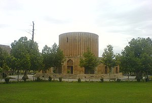 Sun Palace of the Afsharid dynasty | |
 Kalat | |
| Coordinates: 36°59′42″N 59°46′01″E / 36.99500°N 59.76694°ECoordinates: 36°59′42″N 59°46′01″E / 36.99500°N 59.76694°E | |
| Country | |
| Province | Razavi Khorasan |
| County | Kalat |
| Bakhsh | Central |
| Population (2016 Census) | |
| • Total | 7,687 [1] |
| Time zone | UTC+3:30 (IRST) |
| • Summer (DST) | UTC+4:30 (IRDT) |
| Kalat, Razavi Khorasan at GEOnet Names Server | |

Kalat (Persian: كلات; also Romanized as Kalāt; also known as Kalūt)[2] is a city and capital of Kalat County, in Razavi Khorasan Province, Iran. At the 2006 census, its population was 6,529, in 1,661 families.[3] Nader Shah governed the area after the fall of the Safavids.[4]
See also[]
- Kalat-i-nadiri.
- Reza Qoli Mirza Afshar
References[]
- ^ https://www.amar.org.ir/english
- ^ Kalat, Razavi Khorasan can be found at GEOnet Names Server, at this link, by opening the Advanced Search box, entering "-3068804" in the "Unique Feature Id" form, and clicking on "Search Database".
- ^ "Census of the Islamic Republic of Iran, 1385 (2006)" (Excel). Statistical Center of Iran. Archived from the original on 2011-11-11.
- ^ Axworthy, Michael (2009). The Sword of Persia: Nader Shah, from Tribal Warrior to Conquering Tyrant. I.B. Tauris. ISBN 978-1845119829.
- Tod, J. K. (1923) "Kalat-I-Nadiri", The Geographical Journal 62(5): pp. 366–370
External links[]
- Kalāt-e Nāderi, in Persian, Jadid Online, 2006, [1].
A Slide Show of Kalāt-e Nāderi by Shahāb Āzādeh, Jadid Online, 2006, [2] (2 min 30 sec). - Farshid Sāmāni, Konj-e Denj-e Fāteh-e Hend (The Quiet Corner of the Conqueror of India), in Persian, Jadid Online, 14 January 2010, [3].
• Audio slideshow: [4] (3 min 38 sec).

| Capital |
| ||||||||||||||||||||
|---|---|---|---|---|---|---|---|---|---|---|---|---|---|---|---|---|---|---|---|---|---|
| Districts |
| ||||||||||||||||||||
This Kalat County location article is a stub. You can help Wikipedia by . |
Categories:
- Populated places in Kalat County
- Cities in Razavi Khorasan Province
- Nishapur Quarter
- Kalat County geography stubs