Mahvelat County
Mahvelat County
شهرستان مهولات | |
|---|---|
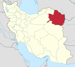
 Location of MahVelat County in Razavi Khorasan province | |
 Location of Razavi Khorasan Province in Iran | |
| Country | |
| Province | Razavi Khorasan Province |
| Capital | Feyzabad |
| Bakhsh (Districts) | Central District, Shadmehr District |
| Population (2016)[1] | |
| • Total | 51,409 |
| Time zone | UTC+3:30 (IRST) |
| • Summer (DST) | UTC+4:30 (IRDT) |
Mahvelat County (Persian: شهرستان مهولات) is a county in Razavi Khorasan Province in Iran. The capital of the county is Feyzabad. At the 2006 census, the county's population was 47,068, in 12,268 families.[2] The county has two districts: Central District and Shadmehr District. The county has two cities: Feyzabad and Shadmehr.
Geographical location[]
Mahvelat is one of the most important cities of Khorasan Razavi province in the center of Feyzabad city, which consists of two central parts and Shadmehr. This city is limited from the north to Torbat-e Heydarieh city, from the east to Rashtkhar city and Khaf city, from the south to Gonabad city and from the west to Khalilabad city and Kashmar city. If you register statistics about 510,000 people in this city and in different cases, it will provide it to you.
Mehvalat plain and plain is located in the eastern lands of Namak desert and in the southwestern part of Torbat Heydariyeh city and in the shadow of Hesar river mountains and continuation of Qaleh Jogh mountains, Sorkhabad mountain in the north, Azghand mountains, Siah mountain, Fadafan mountain in the west of Mahwalat And Kuh-e Kabir with north and south directions, which form the distance between Khaf, Rashtkhar and Gonabad plains to the lowlands and heights of this region. Mahwalat city has permanent rivers, such as Hesar, Majan, Sorkhabad and Kalshor rivers, and is a hot, dry, desert and low-rainfall region.
References[]
- ^ "Census of the Islamic Republic of Iran, 1395 (2016)" (Excel). Islamic Republic of Iran.
- ^ "Census of the Islamic Republic of Iran, 1385 (2006)" (Excel). Statistical Center of Iran. Archived from the original on 2011-11-11.
- اطلس گیتاشناسی استانهای ایران [Atlas-e Gitashenasi-ye Ostanha-ye Iran] (Gitashenasi Province Atlas of Iran)
Coordinates: 35°01′05″N 58°47′21″E / 35.018138°N 58.789155°E
- Mahvelat County
- Counties of Razavi Khorasan Province
- Mahvelat County geography stubs

