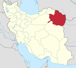
Khaf County
This article may be expanded with text translated from the corresponding article in Persian. (November 2010) Click [show] for important translation instructions.
|
Khaf County
شهرستان خواف | |
|---|---|
County | |
 Location of Khaf County in Razavi Khorasan province | |
 Location of Razavi Khorasan Province in Iran | |
| Coordinates: 34°30′N 60°00′E / 34.500°N 60.000°ECoordinates: 34°30′N 60°00′E / 34.500°N 60.000°E | |
| Country | |
| Province | Razavi Khorasan Province |
| Capital | Khaf, Iran |
| Bakhsh (Districts) | Central District, Sangan District, Jolgeh Zozan District, Salami District |
| Population (2016)[1] | |
| • Total | 138,972 |
| Time zone | UTC+3:30 (IRST) |
| • Summer (DST) | UTC+4:30 (IRDT) |
| Khaf County at GEOnet Names Server | |
Khaf County (Persian: شهرستان خواف, Šahrestâne Xvâf) is a county in Razavi Khorasan Province in Iran. The capital of the county is Khaf. It is a small border town about 350 km ( or 265 km?) from Mashhad.
the historical city of Zozan is located close to Khaf and is registered in the by UNESCO.[2] At the 2006 census, the county's population was 108,964, in 23,896 families.[3]
The county consists of four districts: Central District, Sangan District, Jolgeh Zozan District, and Salami District.
The county contains five cities: Khaf, Nashtifan, Qasemabad, Salami, and Sangan.
References[]
- ^ "Census of the Islamic Republic of Iran, 1395 (2016)" (Excel). Islamic Republic of Iran.
- ^ Zozan-Khaf World Heritage tentative List by UNESCO
- ^ "Census of the Islamic Republic of Iran, 1385 (2006)" (Excel). Statistical Center of Iran. Archived from the original on 2011-11-11.
Categories:
- Khaf County
- Counties of Razavi Khorasan Province
- Khaf County geography stubs

