Kfarhata
Kfarhata
كفرحاتا | |
|---|---|
City | |
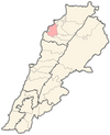
 Kfarhata Location within Lebanon | |
| Coordinates: 34°17′0″N 35°45′0″E / 34.28333°N 35.75000°ECoordinates: 34°17′0″N 35°45′0″E / 34.28333°N 35.75000°E | |
| Country | |
| Governorate | North Governorate |
| District | Koura District |
| Elevation | 170 m (560 ft) |
| Time zone | UTC+2 (EET) |
| • Summer (DST) | UTC+3 (EEST) |
| Dialing code | +961 |

Kfarhata ( known also as Kfar Hata, Kafrhata, Arabic: كفرحاتا ) is a village located in the Koura District in the North Governorate of Lebanon. It is one of the 52 towns of El-Koura, situated at the southern region of this district, at the other side of Al-Kateh (The cutter); a shallow but wide valley, separating a group of 6 towns from the gigantic El-Koura olive plains.
The population is Greek Orthodox and Maronite.[1]
Although the mountainous profile of this town, the olive trees cultivation is equally successful and popular, with high quality of olive oil, extracted with the traditional Koranian cold technique.
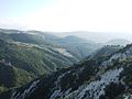
Poster El-koura "Cutter". Western view

Poster El-koura "Cutter". Eastern view


See also[]
References[]
- ^ "Municipal and ikhtiyariah elections in Northern Lebanon" (PDF). The Monthly. March 2010. p. 23. Archived from the original on 3 June 2016. Retrieved 31 October 2016.CS1 maint: bot: original URL status unknown (link)
External links[]
- Kfar Hata, Localiban
Capital: Amioun | ||
| Towns and villages |
|  |
| Notable landmarks |
| |
Categories:
- Archaeological sites in Lebanon
- Eastern Orthodox Christian communities in Lebanon
- Maronite Christian communities in Lebanon
- Populated places in the North Governorate
- Koura District