King Street–Old Town station
King Street – Old Town | ||||||||||||||||
|---|---|---|---|---|---|---|---|---|---|---|---|---|---|---|---|---|
 | ||||||||||||||||
| Location | 1900 King Street, Alexandria, Virginia | |||||||||||||||
| Coordinates | 38°48′24″N 77°03′39″W / 38.80667°N 77.06083°WCoordinates: 38°48′24″N 77°03′39″W / 38.80667°N 77.06083°W | |||||||||||||||
| Owned by | WMATA | |||||||||||||||
| Platforms | 1 island platform | |||||||||||||||
| Tracks | 2 | |||||||||||||||
| Connections | ||||||||||||||||
| Construction | ||||||||||||||||
| Structure type | Embankment | |||||||||||||||
| Parking | 30 spaces (parking meters) | |||||||||||||||
| Bicycle facilities | 34 racks, 20 lockers | |||||||||||||||
| Disabled access | Yes | |||||||||||||||
| Other information | ||||||||||||||||
| Station code | C13 | |||||||||||||||
| History | ||||||||||||||||
| Opened | December 17, 1983 | |||||||||||||||
| Rebuilt | 2019 | |||||||||||||||
| Previous names | King Street (1983–2011) | |||||||||||||||
| Passengers | ||||||||||||||||
| 2017 | 6,752 daily [1] | |||||||||||||||
| Services | ||||||||||||||||
| ||||||||||||||||
| Location | ||||||||||||||||
 King Street–Old Town Location within Alexandria | ||||||||||||||||
King Street–Old Town (also known by its former name, King Street) is an Washington Metro station in Alexandria, Virginia, United States. The station opened on December 17, 1983, and is operated by the Washington Metropolitan Area Transit Authority (WMATA). Providing service for both the Blue and Yellow Lines, this is the southernmost transfer station for the Blue and Yellow lines, as the two lines diverge just south of the station. During inclement weather, Crystal City is commonly used as an unofficial transfer point, being the southernmost underground station common to both lines. King Street was originally served only by the Yellow Line, until the Blue Line was extended from National Airport to Van Dorn Street in 1991.
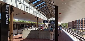
The station is located at King Street and Commonwealth Avenue. Entrances to the station are located on King Street and on the Diagonal Road side of the station. The station is above ground, and access to the single island platform is provided by one pair of escalators, one staircase, and one elevator.
History[]
Originally scheduled to open in summer 1982, its opening was delayed due to both unavailability of new subway cars and the lack of a test track.[2] Construction of the station was complete by summer 1982,[3] and in September 1983 Metro announced the station would open that December as the new cars would be ready for service.[4] The station opened on December 17, 1983.[5] Its opening coincided with the completion of 4.2 miles (6.8 km)[6] of rail between National Airport and Huntington and the opening of the Braddock Road, Eisenhower Avenue and Huntington stations.[5]
An expansion to the station added a second entrance and mezzanine across Commonwealth Avenue from the existing mezzanine, with the new entrance located on Cameron Street, across from the nearby Hilton Hotel. The expansion also includes a new canopy over the north end of the platform, designed to match the original canopy.[7][8] A gap was left between the two canopies to preserve the view of the George Washington Masonic Memorial from Old Town.
The station was named King Street from its 1983 opening until November 3, 2011, when the station was given its present name as part of a preparation for service changes planned for 2012.[9]
In May 2018, Metro announced an extensive renovation of platforms at twenty stations across the system. The Blue and Yellow Lines south of Ronald Reagan Washington National Airport station, including the King Street–Old Town station, were closed from May 25 to September 9, 2019, during which the platforms at this station were be rebuilt, along with new platform tiles, new passenger information displays, and other improvements.[10][11][12]
The bus, parking, and Kiss and Ride area of King is undergoing a complete reconstruction and is closed, beginning November 2018 until planned reopening dates of Spring 2020 for buses and Fall 2020 for Kiss and Ride and taxis.[13] Temporary bus bays are on Diagonal Road, along portions of Daingerfield Road, and on King Street.
Transit connections[]
The station is adjacent to Alexandria Union Station, together with which it serves Old Town Alexandria and as a transit hub for the city as a whole. Plans are in place to build a tunnel to allow a direct connection between the heavy rail station and the Metro station; presently transfers must be made by exiting either station and walking along a narrow sidewalk on King Street.[14] Both Metrobus and DASH provide service to the station. A free daily trolley service provides direct access to Old Town and the Waterfront, making many stops along King Street. Car sharing is also available. The station is about 12 blocks (one mile or 1.6 kilometers) from the intersection of King and Washington Streets; it is about 17 blocks from the Waterfront.
Station layout[]
The station has an elevated island platform over King Street west of Diagonal Road. Two fare control areas on either side of King Street provide escalator and elevator access to the platform.
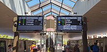
| P Platform level |
Southbound | ← ← |
| Island platform | ||
| Northbound | | |
| G | Street level | Exit/entrance, buses, parking, fare control, ticket machines, station agent |
Notable places nearby[]
- George Washington Masonic National Memorial
- National Science Foundation
- Regent University, Alexandria Campus
- United States Patent and Trademark Office (PTO)
References[]
- ^ "Metrorail Average Weekday Passenger Boardings" (PDF). WMATA. Retrieved October 12, 2019.
- ^ Feaver, Douglas B. (January 30, 1981). "Status of future Metro openings". The Washington Post. p. C5.
- ^ Battiata, Mary (September 22, 1982). "Alexandria angered by delays in opening of subway". The Washington Post. p. VA1.
- ^ Lynton, Stephen J. (September 21, 1983). "Metro panel approves plan for December Yellow Line opening". The Washington Post. p. C4.
- ^ a b Burgess, John (December 20, 1983). "Yellow Line trains run smoothly as new stations get first test". The Washington Post. p. C3.
- ^ Washington Metropolitan Area Transit Authority (July 2009). "Sequence of Metrorail openings" (PDF). Archived from the original (PDF) on January 13, 2010. Retrieved July 25, 2010.
- ^ O'Hanlon, Ann (February 14, 2002). "King Street Metro Station to get more entrances". The Washington Post. p. T3.
- ^ Staff Reporters (September 21, 2004). "Ground was broken yesterday on $16 million in improvements to the King Street Station". The Washington Post. p. B3.
- ^ "Station names updated for new map" (Press release). Washington Metropolitan Area Transit Authority. November 3, 2011. Archived from the original on November 5, 2011. Retrieved November 5, 2011.
- ^ "Metro wants to rebuild 20 station platforms over three years, creating SafeTrack-like disruptions". Washington Post. May 7, 2018. Retrieved February 19, 2019.
- ^ "Metro plans 'summer shutdown' on Blue, Yellow lines next year". WTOP. May 7, 2018. Retrieved February 19, 2019.
- ^ "Six Metro stations on Blue and Yellow lines reopen - The Washington Post".
- ^ "King Street-Old Town Metro Access Improvement Project | City of Alexandria, VA".
- ^ "Alexandria Pedestrian Tunnel". VRE. VRE. Retrieved December 17, 2017.
External links[]
| Wikimedia Commons has media related to King Street–Old Town (WMATA station). |
- The Schumin Web Transit Center: King Street–Old Town Station
- South entrance from Google Maps Street View
- King Street entrance from Google Maps Street View
- Commonwealth Avenue entrance from Google Maps Street View
- Blue Line (Washington Metro)
- Washington Metro stations in Virginia
- Yellow Line (Washington Metro)
- Railway stations in the United States opened in 1983
- Transportation in Alexandria, Virginia
- 1983 establishments in Virginia
- Washington Metro stations located above ground