West Falls Church station
West Falls Church VT/UVA | |||||||||||
|---|---|---|---|---|---|---|---|---|---|---|---|
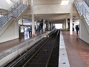 The center track, used for train storage | |||||||||||
| Location | 7040 Haycock Road, Falls Church, Virginia | ||||||||||
| Owned by | Washington Metropolitan Area Transit Authority | ||||||||||
| Line(s) | |||||||||||
| Platforms | 2 island platforms | ||||||||||
| Tracks | 3 | ||||||||||
| Connections | |||||||||||
| Construction | |||||||||||
| Structure type | Surface | ||||||||||
| Parking | 2,009 spaces | ||||||||||
| Bicycle facilities | 40 racks, 22 lockers | ||||||||||
| Disabled access | Yes | ||||||||||
| Other information | |||||||||||
| Station code | K06 | ||||||||||
| History | |||||||||||
| Opened | June 7, 1986 | ||||||||||
| Rebuilt | 2020 | ||||||||||
| Previous names | West Falls Church (1986–1999, 2011–present) West Falls Church–VT/UVA (1999–2011) | ||||||||||
| Passengers | |||||||||||
| 2017 | 2,411 daily [1] | ||||||||||
| Services | |||||||||||
| |||||||||||
West Falls Church is a Washington Metro station in Idylwood, Virginia on the Orange Line, the first station inside the beltway on the Orange Line going east. It is one of only two stations in the system to have three tracks, the other being the National Airport station. The center track is used for train storage, and for relaying trains to the adjacent Falls Church Yard.
Facilities[]


The station serves the suburban community of Falls Church and the Northern Virginia Center operated by Virginia Tech and the University of Virginia. While the station has a street address on Haycock Road, it is physically located in the median of Interstate 66 near Virginia State Route 7 (Leesburg Pike); riders access the platform and mezzanine by means of an elevated walkway from the parking area.
This is a major suburban transfer station, as many commuter buses that serve communities near the Dulles Toll and Access Roads (Virginia State Route 267) connect to the Metro system at West Falls Church using a bus-only exit from the Access Road. These buses include Fairfax Connector to points within Fairfax including Reston and Herndon, Metrobus to Tysons Corner, and Loudoun County Transit reverse commute routes to businesses including AOL and MCI and transfer points in Dulles.
With the opening of the Silver Line on July 26, 2014, many commuter bus routes that formerly terminated at West Falls Church were rerouted to instead terminate at locations along the new Silver Line stations in Tysons Corner and Reston. [2] West Falls Church was also the original staging point for Washington Flyer buses to Dulles Airport, but this shifted to Wiehle-Reston East with the opening of the Silver Line.[3]
The Silver Line joins the Orange Line via a flying junction immediately east of this station but does not serve the station. Plans originally called for the Silver Line to stop at West Falls Church, but it was cut out of the final plan.
History[]
The station opened on June 7, 1986.[4] Its opening coincided with the completion of 9.1 miles (14.6 km) of rail west of the Ballston station and the opening of the East Falls Church, Dunn Loring and Vienna stations.[4]
In 1999, the station was renamed West Falls Church–VT/UVA, when the initialisms for Virginia Tech and the University of Virginia were added to the station's name, two years after the dedication of the shared graduate center. These initialisms were moved to a subtitle location on November 3, 2011.[5]
In May 2018, Metro announced an extensive renovation of platforms at twenty stations across the system. The platforms at the West Falls Church station would be rebuilt starting in late 2020.[6]
From May 23 until August 15, 2020, this station was closed due to the platform reconstruction project which closed stations west of Ballston–MU station.[7][8] On August 16, 2020, the station reopened as the Orange Line terminus when Silver and Orange Line trains were able to bypass East Falls Church station.[9][10]
Station layout[]
| G | Street level | Exit/entrance, buses, parking, fare control, ticket machines, station agent |
| P Platform level |
Westbound | ← |
| Island platform | ||
| Center track | No regular service | |
| Island platform | ||
| Eastbound | | |
References[]
- ^ "Metrorail Average Weekday Passenger Boardings" (PDF). Washington Metropolitan Area Transit Authority. May 2017. Retrieved February 17, 2018.
- ^ "Bus service changes to Silver Line". Fox 5 DC. July 23, 2014. Retrieved August 13, 2014.
- ^ [1][dead link]
- ^ a b Lynton, Stephen J. (June 8, 1986), "9.1 more miles for Metrorail", The Washington Post, p. C1
- ^ "Station names updated for new map" (Press release). Washington Metropolitan Area Transit Authority. November 3, 2011. Archived from the original on November 5, 2011. Retrieved November 5, 2011.
- ^ "Metro wants to rebuild 20 station platforms over three years, creating SafeTrack-like disruptions". Washington Post. May 7, 2018. Retrieved February 19, 2019.
- ^ "Metro to use upcoming low-ridership summer to maximum effect, expands Orange, Silver line shutdown". www.wmata.com. Retrieved April 23, 2020.
- ^ "Platform Improvement Project | WMATA". www.wmata.com. Retrieved May 24, 2020.
- ^ "Silver Line service will return August 16, along with reopening of six stations in Fairfax County | WMATA". www.wmata.com. Retrieved July 11, 2020.
- ^ "Metro to add more buses, trains and extended hours as part of Covid-19 Recovery Plan beginning Sunday, August 16 | WMATA". www.wmata.com. Retrieved August 16, 2020.
External links[]
 Media related to West Falls Church (WMATA station) at Wikimedia Commons
- The Schumin Web Transit Center: West Falls Church Station
- Station from Google Maps Street View
Coordinates: 38°54′03″N 77°11′21″W / 38.900773°N 77.189298°W

- Bus stations in Virginia
- Orange Line (Washington Metro)
- Washington Metro stations in Virginia
- Railway stations in the United States opened in 1986
- Transportation in Fairfax County, Virginia
- 1986 establishments in Virginia
- Washington Metro stations located above ground
- Railway stations in highway medians