Southern Avenue station
Southern Avenue | |||||||||||
|---|---|---|---|---|---|---|---|---|---|---|---|
 | |||||||||||
| Location | 1141 Southern Avenue, Temple Hills, Maryland | ||||||||||
| Owned by | Washington Metropolitan Area Transit Authority | ||||||||||
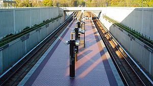
| Platforms | 1 island platform | ||||||||||
| Tracks | 2 | ||||||||||
| Connections | |||||||||||
| Construction | |||||||||||
| Structure type | Open-cut | ||||||||||
| Parking | 1,980 spaces | ||||||||||
| Bicycle facilities | 14 racks, 40 lockers | ||||||||||
| Disabled access | Yes | ||||||||||
| Other information | |||||||||||
| Station code | F08 | ||||||||||
| History | |||||||||||
| Opened | January 13, 2001 | ||||||||||
| Passengers | |||||||||||
| 2016 | 4,612 daily [1] | ||||||||||
| Services | |||||||||||
| |||||||||||
Southern Avenue is an island platformed Washington Metro station in Hillcrest Heights, Maryland, United States. The station was opened on January 13, 2001, and is operated by the Washington Metropolitan Area Transit Authority (WMATA). Providing service for only the Green Line, the station is located on the southern side of Southern Avenue, putting it just outside the District of Columbia, opposite Valley Terrace. Southern Avenue is the first station in Maryland going southeast on the Green Line.
Groundbreaking for the final segment of the Green Line occurred on September 23, 1995,[2] and the station opened on January 13, 2001.[3] Its opening coincided with the completion of approximately 6.5 miles (10.5 km) of rail southeast of the Anacostia station and the opening of the Branch Avenue, Congress Heights, Naylor Road and Suitland stations.[3]
This station provides service to the National Harbor via Metrobus route NH1 and TheBus route 35.
Station layout[]
Although this station is open-cut, and the next station east (railroad south) (Naylor Road) is elevated, there is an underground section of the Green Line's tracks between these two stations; additionally, the Southern Avenue station descends into a tunnel at its western (railroad northern) end.
| M | Mezzanine | Overpass to parking garage |
| G | Street level | Exit/entrance, buses, fare gates, ticket machines, station agent |
| P Platform level |
Southbound | ← |
| Island platform | ||
| Northbound | | |
References[]
- ^ "Metrorail Average Weekday Passenger Boardings" (PDF). WMATA. Retrieved April 26, 2017.
- ^ Fehr, Stephen C. (September 23, 1995), "After 25 years of building, Metro nears finish line", The Washington Post, p. B1
- ^ a b Layton, Lyndsey (January 14, 2001), "All Metro doors now open; Five new Green Line stations complete 32-year project, but expansions continue", The Washington Post, p. A1
External links[]
| Wikimedia Commons has media related to Southern Avenue (WMATA station). |
- The Schumin Web Transit Center: Southern Ave Station
- Station from Google Maps Street View
Coordinates: 38°50′27.6″N 76°58′30.3″W / 38.841000°N 76.975083°W

This article relating to the Washington Metropolitan Area Transit Authority is a stub. You can help Wikipedia by . |
This Maryland train station-related article is a stub. You can help Wikipedia by . |
- Green Line (Washington Metro)
- Washington Metro stations in Maryland
- Railway stations in the United States opened in 2001
- 2001 establishments in Maryland
- Washington Metro stations located above ground
- Washington Metro stubs
- Maryland railway station stubs