Kir (river)
| Kir Lumi i Kirit[1] | |
|---|---|
 Kir Gorge at Plan | |
| Location | |
| Country | Albania |
| Physical characteristics | |
| Source | |
| • location | Albanian Alps |
| Mouth | |
• location | Great Drin |
• coordinates | 42°02′35″N 19°29′56″E / 42.04306°N 19.49889°ECoordinates: 42°02′35″N 19°29′56″E / 42.04306°N 19.49889°E |
• elevation | 6 m (20 ft) |
| Basin features | |
| Progression | Great Drin→ Bojana→ Adriatic Sea |

| Part of a series on |
| Albanian tribes |
|---|
 |
Kir River near Boks
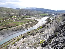
The Kir (Albanian: Kir or Kiri) is a river in northern Albania that first flows south-southwest and then southwest out of the North Albanian Alps and enters a distributary of the Drin just below Shkodër.[2]
In the upper reaches the river cuts the "Canyon of the Kir" with dramatic cliffs.The Albanian tribe or fis of Kiri inhabited this area. Just outside Shkodër, in , the old stone Mes Bridge crosses the Kir.
Notes[]
- ^ Lumi i Kirit (Approved) at GEOnet Names Server, United States National Geospatial-Intelligence Agency, Kiri (Variant) at GEOnet Names Server, United States National Geospatial-Intelligence Agency
- ^ "Kiri", Topographic map 1:250,000, Titograd, NK-34-04, series 1501, United States Defense Intelligence Agency
External links[]
- "Photo of Kirit River Valley". Panoramio. Archived from the original on 2018-12-15. Retrieved 2017-10-31. Static image
- "Photo of The Mes Bridge - Shkoderpublisher=Panoramio". Archived from the original on 2018-12-15. Retrieved 2017-10-31. Static image
Categories:
- Tributaries of the Bojana
- Rivers of Albania
- Geography of Shkodër County
- Europe river stubs
- Albania geography stubs