Larré, Morbihan
Larré
Lare | |
|---|---|
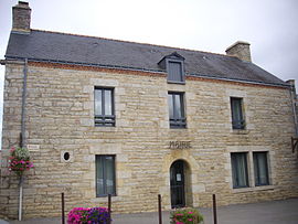 The town hall in Larré | |
 Coat of arms | |
show Location of Larré | |
 Larré | |
| Coordinates: 47°42′45″N 2°30′55″W / 47.7125°N 2.5153°WCoordinates: 47°42′45″N 2°30′55″W / 47.7125°N 2.5153°W | |
| Country | France |
| Region | Brittany |
| Department | Morbihan |
| Arrondissement | Vannes |
| Canton | Questembert |
| Intercommunality | Questembert Communauté |
| Government | |
| • Mayor (2020–2026) | Simone Malville[1] |
| Area 1 | 17.02 km2 (6.57 sq mi) |
| Population (Jan. 2018)[2] | 1,050 |
| • Density | 62/km2 (160/sq mi) |
| Time zone | UTC+01:00 (CET) |
| • Summer (DST) | UTC+02:00 (CEST) |
| INSEE/Postal code | 56108 /56230 |
| Elevation | 22–131 m (72–430 ft) |
| 1 French Land Register data, which excludes lakes, ponds, glaciers > 1 km2 (0.386 sq mi or 247 acres) and river estuaries. | |


Larré (French pronunciation: [laʁe] (![]() listen); Breton: Lare) is a commune in the Morbihan department of Brittany in north-western France.
listen); Breton: Lare) is a commune in the Morbihan department of Brittany in north-western France.
Geography[]
The river Arz forms all of the commune's northern border.
Demographics[]
Inhabitants of Larré are called in French Larréens.
See also[]
References[]
- ^ "Maires du Morbihan" (PDF). Préfecture du Morbihan. 7 July 2020.
- ^ "Populations légales 2018". INSEE. 28 December 2020.
External links[]
| Wikimedia Commons has media related to Larré (Morbihan). |
- Base Mérimée: Search for heritage in the commune, Ministère français de la Culture. (in French)
- Mayors of Morbihan Association (in French)
| show Authority control |
|---|
This Morbihan geographical article is a stub. You can help Wikipedia by . |
Categories:
- Communes of Morbihan
- Morbihan geography stubs