Ploemel
Ploemel
Pleñver | |
|---|---|
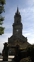 The Church of Saint-André, in Ploemel | |
show Location of Ploemel | |
 Ploemel | |
| Coordinates: 47°39′04″N 3°04′13″W / 47.6511°N 3.0703°WCoordinates: 47°39′04″N 3°04′13″W / 47.6511°N 3.0703°W | |
| Country | France |
| Region | Brittany |
| Department | Morbihan |
| Arrondissement | Lorient |
| Canton | Quiberon |
| Intercommunality | Auray Quiberon Terre Atlantique |
| Government | |
| • Mayor (2020–2026) | Jean-Luc Le Tallec[1] |
| Area 1 | 25.16 km2 (9.71 sq mi) |
| Population (Jan. 2018)[2] | 2,938 |
| • Density | 120/km2 (300/sq mi) |
| Time zone | UTC+01:00 (CET) |
| • Summer (DST) | UTC+02:00 (CEST) |
| INSEE/Postal code | 56161 /56400 |
| Elevation | 5–53 m (16–174 ft) |
| 1 French Land Register data, which excludes lakes, ponds, glaciers > 1 km2 (0.386 sq mi or 247 acres) and river estuaries. | |


Ploemel (French pronunciation: [plɛmɛl];[3] Breton: Pleñver) is a commune in the Morbihan department of Brittany in north-western France.
Transportation[]
The Belz-Ploemel railway station is served by TER Bretagne trains on the Auray-Quiberon railway during the summer.[4]
See also[]
References[]
- ^ "Maires du Morbihan" (PDF). Préfecture du Morbihan. 7 July 2020.
- ^ "Populations légales 2018". INSEE. 28 December 2020.
- ^ Commune Ploemel. "Émission "ma commune vaut le détour" : Ploemel".
- ^ "TER Bretagne - Horaires et informations pratiques au départ de la gare de Belz-Ploemel". www.ter.sncf.com. Retrieved 2020-05-14.
External links[]
| Wikimedia Commons has media related to Ploemel. |
- Mayors of Morbihan Association (in French)
- INSEE commune file
- Official site (in French)
- Base Mérimée: Search for heritage in the commune, Ministère français de la Culture. (in French)
| show Authority control |
|---|
This Morbihan geographical article is a stub. You can help Wikipedia by . |
Categories:
- Communes of Morbihan
- Morbihan geography stubs