Lendelede
Lendelede | |
|---|---|
 Church of Saint Blaise (Sint-Blasius) | |
 Flag  Coat of arms | |
 Lendelede Location in Belgium
show Location of Lendelede in West-Flanders | |
| Coordinates: 50°53′N 03°14′E / 50.883°N 3.233°ECoordinates: 50°53′N 03°14′E / 50.883°N 3.233°E | |
| Country | Belgium |
| Community | Flemish Community |
| Region | Flemish Region |
| Province | West Flanders |
| Arrondissement | Kortrijk |
| Government | |
| • Mayor | Georges Gheysens |
| • Governing party/ies | CD&V |
| Area | |
| • Total | 13.15 km2 (5.08 sq mi) |
| Population (2018-01-01)[1] | |
| • Total | 5,742 |
| • Density | 440/km2 (1,100/sq mi) |
| Postal codes | 8860 |
| Area codes | 051, 056 |
| Website | www.lendelede.be |


Lendelede is a municipality located in the Belgian province of West Flanders. The municipality comprises only the town of Lendelede proper. On January 1, 2006, Lendelede had a total population of 5,399. The total area is 13.15 km2 which gives a population density of 411 inhabitants per km2.
People from Lendelede[]
Gallery[]
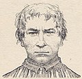
, 1774–1803, highwayman
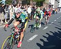
2007 Tour of Flanders through Lendelede with Jan Kuyckx (landbouwkrediet); Aleksandr Kuschynski (Liquigas); Evert Verbist (- Topsport Vlaanderen)


References[]
- ^ "Wettelijke Bevolking per gemeente op 1 januari 2018". Statbel. Retrieved 9 March 2019.
External links[]
 Media related to Lendelede at Wikimedia Commons
- Official website (in Dutch)
| show Places adjacent to Lendelede |
|---|

| show Authority control |
|---|
This West Flanders location article is a stub. You can help Wikipedia by . |
Categories:
- Municipalities of West Flanders
- West Flanders geography stubs